
According to the Environmental Impact Assessment Report of the Ben Thanh – Can Gio Railway Project conducted by Vinspeed High-Speed Railway Investment and Development Joint Stock Company, the metro line connecting the center of Ho Chi Minh City with Can Gio has a length of 52.92km, with a total investment of more than VND85,650 billion, equivalent to about USD4 billion.
The project is expected to start construction at the end of this year and be completed and put into operation in 2028. The construction and equipment installation will be carried out from the fourth quarter of 2025 to the third quarter of 2027. At the end of 2027, the unit will conduct a trial operation and begin commercial operation in the first quarter of 2028.
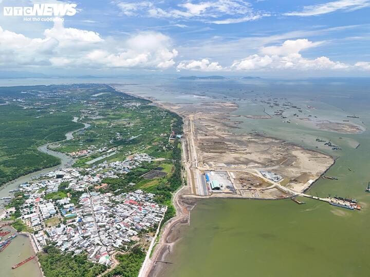
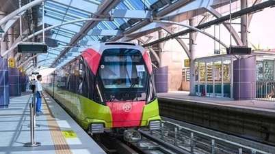
The Ben Thanh-Can Gio metro line has its end point located in Can Gio urban area. (Photo: Luong Y)
The report shows that this metro line has its starting point at Ben Thanh station of metro line 1 Ben Thanh-Suoi Tien; its ending point is in Can Gio commune. There is 1 depot planned to be located in Can Gio commune and 2 maintenance centers located in Can Gio and Tan Thuan (old District 7).
This route has 2 phases of station investment. Phase 1 has 2 stations: Ben Thanh and Can Gio.
Phase 2 has 4 stations including Tan Thuan station, Tan My station, Nha Be station and Binh Khanh station (based on demand). In phase 2, there will be 2 types of trains running, including express trains from the first station to the last station and regular trains stopping at all stations.
The project passes through 8 communes and wards of the city, including Ben Thanh ward, Xom Chieu ward, Tan Thuan ward, Tan My ward, Nha Be commune, Binh Khanh commune, An Thoi Dong commune and Can Gio commune, with a total land use area of about 317.67 hectares.
Ben Thanh-Can Gio Metro is built with double tracks, 1435 mm gauge, designed speed of 350 km/h; expected travel time from the first station to the last station is about 13 minutes.
The entire route is expected to have 5 trains, each with 8 carriages and a capacity of 600 passengers using fixed seats, no standing room.
Train frequency is expected to be 20 minutes/trip, applied uniformly for both peak and off-peak hours of the day, starting from 6am-11pm every day of the week.
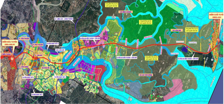
Map of Ben Thanh-Can Gio metro route. (Source: Vinspeed)
The route starts from Km0+00 at Ham Nghi - Le Loi intersection (Ben Thanh), along Pho Duc Chinh street, crossing Ben Nghe canal to Le Quoc Hung street.
After passing Xom Chieu market, you will change direction along Nguyen Tat Thanh street to Tan Thuan 2 bridge area to Nguyen Van Linh street through the intersection with Nguyen Thi Thap street (about Km4+950) to Tan My ward.
This route continues to cross the intersection between Nguyen Van Linh Street and Phu My Bridge to Nguyen Luong Bang Street; cross Rach Dia River to Nha Be Commune; cross Soai Rap River to Binh Khanh Commune.
Continue parallel to Ben Luc - Long Thanh expressway, then turn Southeast along Rung Sac road, cross Loi Giang river, Dinh Ba river to the end point in Can Gio urban area - Can Gio commune.
The investor said the chosen route goes through the buffer zone of Can Gio Biosphere Reserve without entering the core zone. The Km44+00 route goes to the East, avoiding the boundary of the type I forest protection area.
The Ben Thanh – Can Gio railway project is a new transport infrastructure construction investment project, with direct investment. The project is expected to employ about 400 workers after being put into operation.
Previously, on October 29, the Office of the Ho Chi Minh City People's Committee announced the conclusion of the Chairman of the Ho Chi Minh City People's Committee Nguyen Van Duoc, at the meeting to resolve the petition of Vingroup Corporation, including the urban railway project connecting the center of Ho Chi Minh City - Can Gio.
The investor proposed extending the metro line connecting Can Gio to the center of Ho Chi Minh City to Ben Thanh station - connecting directly at Ben Thanh station of line 1 Ben Thanh - Suoi Tien, instead of stopping at Tan Thuan (old District 7).

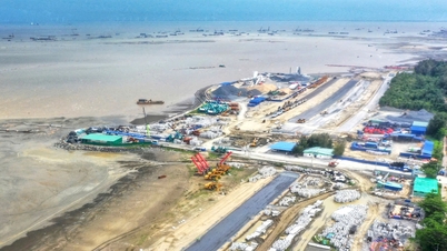
The urban railway connecting Can Gio runs parallel to the Sac forest road in Can Gio. (Photo: Luong Y)
The adjustment of the route to Ben Thanh station aims to improve operational efficiency, increase service coverage, and connectivity to residential areas, commercial centers, and the city's administrative economic center. In addition, the route adjustment increases connectivity with the city's metro network, contributing to the formation of a synchronous and convenient public transport network for the people.
The proposed plan for the Ben Thanh to Tan Thuan section is to go underground to reduce compensation and clearance costs. The section from Tan Thuan to Can Gio will continue to be implemented according to the previously proposed plan.
Chairman of the Ho Chi Minh City People's Committee Nguyen Van Duoc supported the proposal to adjust the starting point of the route from Tan Thuan station to Ben Thanh station, and requested investors to continue studying the route direction, to ensure feasibility, optimize exploitation capacity, increase connectivity and serve socio-economic development according to the urban space development orientation of Ho Chi Minh City, and maximize investment efficiency.
At the same time, coordinate with relevant departments and branches to update additional route directions to the urban railway planning.
According to the old plan, the metro line connecting the center of Ho Chi Minh City to Can Gio is about 48.5 km long, running on an elevated route, starting at Tan Thuan ward, ending at Can Gio coastal urban area, with a total investment of about 2.9 billion USD.
Source: https://vtcnews.vn/metro-ben-thanh-can-gio-nang-von-len-85-650-ty-dong-chuan-bi-khoi-cong-ar985910.html


![[Photo] Da Nang: Hundreds of people join hands to clean up a vital tourist route after storm No. 13](https://vphoto.vietnam.vn/thumb/1200x675/vietnam/resource/IMAGE/2025/11/07/1762491638903_image-3-1353-jpg.webp)


Comment (0)