
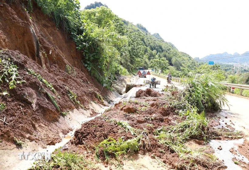
Heavy rain caused landslides on National Highway 4D, the section bordering Lai Chau city and Phong Tho district. (Photo: Quy Trung/VNA)
Risk of flash floods on small rivers and streams, landslides on steep slopes in the above provinces and cities, especially in the districts: Muong Te, Phong Tho, Tam Duong, Than Uyen (Lai Chau province); Dien Bien, Muong Ang, Muong Cha, Muong Nhe, Dien Bien Phu city, Tua Chua, Tuan Giao (Dien Bien province); Da Bac (Hoa Binh province); Bat Xat, Lao Cai city, Sa Pa town, Van Ban (Lao Cai province); Luc Yen, Mu Cang Chai, Yen Bai city, Tram Tau, Tran Yen, Van Chan, Yen Binh (Yen Bai province); Bac Me, Bac Quang, Dong Van, Hoang Su Phi, Meo Vac, Quan Ba, Quang Binh, Vi Xuyen, Xin Man, Yen Minh (Ha Giang province); Chiem Hoa, Ham Yen, Lam Binh, Na Hang, Son Duong, Tuyen Quang city, Yen Son (Tuyen Quang province); Ha Hoa, Tan Son, Thanh Son, Thanh Thuy, Yen Lap (Phu Tho province); Ba Be, Bach Thong, Cho Don, Cho Moi, Na Ri, Ngan Son, Pac Nam, Bac Kan city (Bac Kan province); Dai Tu, Dinh Hoa (Thai Nguyen province); Bao Lac, Bao Lam, Ha Lang, Ha Quang, Hoa An, Nguyen Binh, Quang Hoa, Thach An, Trung Khanh (Cao Bang province); Binh Gia, Trang Dinh (Lang Son province).
Warning level of natural disaster risk due to flash floods, landslides, land subsidence due to heavy rain or level 1 flow.
Heavy rains are likely to cause flooding in low-lying areas, urban and industrial areas; flash floods on small rivers and streams, landslides on steep slopes (real-time warning information on areas at risk of flash floods and landslides is provided online on the website of the Department of Hydrometeorology at: https://luquetsatlo.nchmf.gov.vn and in separate bulletins warning of flash floods and landslides).
Flash floods and landslides can have very negative impacts on the environment, threaten people's lives; cause local traffic congestion, affect the movement of vehicles; destroy civil and economic works, causing damage to production and socio-economic activities.
The hydrometeorological agency reminds people to regularly monitor forecast and warning information on the website of the National Center for Hydro-Meteorological Forecasting at nchmf.gov.vn, and provincial, municipal and regional hydrometeorological stations.
At the same time, regularly update the latest hydrometeorological forecast information on the official mass media of the Central and local levels to proactively respond, and at the same time recommend that the authorities in the affected localities pay attention to reviewing the flow bottlenecks and vulnerable locations in the area to take preventive measures.
According to the guidance of the Department of Dyke Management and Natural Disaster Prevention and Control (Ministry of Agriculture and Environment), in the face of the above situation, affected areas should closely monitor developments of heavy rain, floods, flash floods, landslides, and promptly and fully inform authorities at all levels and people to proactively prevent, respond, and minimize damage.
Localities deploy shock forces to inspect and review residential areas along rivers, streams, and low-lying areas to proactively organize the relocation and evacuation of people in areas at high risk of deep flooding, flash floods, and landslides; organize forces ready to control and direct traffic, and place warning signs, especially through culverts, spillways, and areas with deep flooding and fast-flowing water; proactively arrange forces, materials, and means to overcome incidents, ensuring smooth traffic on main traffic routes when heavy rain occurs.
From 7:00 p.m. on May 28 to 7:00 a.m. on May 29, the provinces in the Northern region had moderate to heavy rain, and in some places very heavy rain such as Tam Thanh (Phu Tho) 209.8mm; Tan Minh (Lang Son) 170.4mm; Tan Pheo (Hoa Binh) 138.6mm; Yen Binh (Yen Bai) 123mm; Thi Hoa (Cao Bang) 101.9mm; Tam Da (Tuyen Quang) 100.2mm; Yen Lac (Bac Kan) 85mm; Linh Ho (Ha Giang) 61.2mm.
Soil moisture models show that some areas in the above provinces are nearly saturated (over 85%) or have reached saturation./.
According to VNA
Source: https://baothanhhoa.vn/mua-lon-tiep-tuc-keo-dai-de-phong-lu-quet-sat-lo-dat-o-12-tinh-bac-bo-250263.htm


![[Photo] A delegation of 100 journalists from the Vietnam Journalists Association visits the soldiers and people of Truong Sa island district.](https://vphoto.vietnam.vn/thumb/1200x675/vietnam/resource/IMAGE/2025/5/30/0984a986227d4e988177f560d2e1563e)


![[Photo] Journalists moved to tears at the Memorial Service for the soldiers who died in Gac Ma](https://vphoto.vietnam.vn/thumb/1200x675/vietnam/resource/IMAGE/2025/5/30/9454613a55c54c16bf8c0efa51883456)


![[Photo] Prime Minister Pham Minh Chinh attends the event "Digital transformation of the banking industry by 2025"](https://vphoto.vietnam.vn/thumb/1200x675/vietnam/resource/IMAGE/2025/5/29/0e34cc7261d74e26b7f87cadff763eae)


Comment (0)