
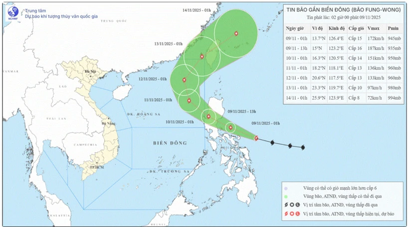
 Location and direction of the storm. (Source: National Center for Hydro-Meteorological Forecasting)
According to the National Center for Hydro-Meteorological Forecasting, storm Fung-wong is moving fast and has very strong intensity (level 15, gusting above level 17).
At 1:00 a.m. on November 9, the center of storm Fung-wong was at about 13.7 degrees North latitude; 126.4 degrees East longitude. The strongest wind near the center of the storm was level 15 (167-183 km/h), gusting to level 17. Moving in a West Northwest direction at a speed of about 30 km/h.
Forecast for November 10, the storm in the Luzon Island area (Philippines) with strong winds of level 14, gusting over level 17, moving in the West Northwest direction at a speed of about 25-30km/h and is likely to strengthen. The affected area is the sea area east of the North East Sea, disaster risk level 3.
Next, at 1:00 a.m. on November 11, the storm in the eastern sea of the North East Sea with strong winds of level 13, gusts of level 16, moving in the West Northwest direction at a speed of about 15-20 km/h. The affected area is the eastern sea of the North East Sea, disaster risk level 3.
At 1:00 a.m. on November 12, the storm in the northeastern sea of the North East Sea with strong winds of level 13, gusts of level 16, moved in the North Northwest direction at a speed of about 10-15 km/h. The affected area is the eastern sea of the North East Sea, with a natural disaster risk level of level 3.
From the next 72 to 120 hours, the storm moved to the North, then Northeast, about 15km per hour, then increased to 20-25km and the intensity tended to decrease.
Due to the influence of the storm, the eastern sea area of the North East Sea has strong winds of level 6-7, later increasing to level 8-10; the area near the storm center has strong winds of level 11-13, gusts of level 16, waves 4-6m high, later increasing to 6-8m, the area near the storm center is 8-10m, the sea is very rough.
According to the warning, between November 10 and 12, the eastern sea area of the North East Sea is likely to be affected by strong storm winds of level 11-13, gusts of level 16, waves of 8-10m high, and rough seas. All boats operating in the above-mentioned dangerous areas are likely to be affected by storms, whirlwinds, strong winds, and large waves.
Weather in regions day and night 11/9:
In the Northwest, there is rain, scattered showers, cold mornings and nights, some places are freezing. Light wind. Lowest temperature 19-22 degrees Celsius, some places below 19 degrees Celsius. Highest temperature 25-28 degrees Celsius, some places above 28 degrees Celsius.
In the Northeast, there will be scattered showers during the day; some rain at night, cold weather, some mountainous areas will be cold. Northeast wind level 2-3. Lowest temperature 20-23 degrees Celsius, some mountainous areas below 20 degrees Celsius. Highest temperature 26-29 degrees Celsius.
Hanoi has scattered rain during the day; rain in some places at night, cold in the early morning and at night. Northeast wind level 2-3. Lowest temperature 21-23 degrees Celsius. Highest temperature 26-28 degrees Celsius.
Provinces and cities from Thanh Hoa to Hue, the North has scattered rain and showers, cold in the early morning and at night; the South has scattered showers and thunderstorms, with the possibility of tornadoes, lightning and strong gusts of wind. North to Northwest wind level 2-3. Lowest temperature 22-25 degrees Celsius. Highest temperature in the North is 27-29 degrees Celsius, in the South is 30-31 degrees Celsius, some places are over 31 degrees Celsius.
The South Central Coast has scattered showers and thunderstorms, with the possibility of tornadoes, lightning, and strong gusts of wind; sunny days. Light winds during the day, and northeast winds at night at level 2-3. Lowest temperature 23-26 degrees Celsius, below 23 degrees Celsius in some places. Highest temperature 30-33 degrees Celsius.
The Central Highlands has scattered showers and thunderstorms, sunny during the day; in the South, there will be scattered showers and thunderstorms in the late afternoon and evening, with the possibility of tornadoes, lightning and strong gusts of wind. The lowest temperature is 19-22 degrees Celsius. The highest temperature is 27-30 degrees Celsius, some places above 30 degrees Celsius.
Southern region: Sunny day; scattered showers and thunderstorms in the afternoon and evening, scattered showers and thunderstorms at night, with the possibility of tornadoes, lightning and strong gusts of wind during thunderstorms. Southwest to West wind level 2-3. Lowest temperature 23-26 degrees Celsius. Highest temperature 30-33 degrees Celsius.
Ho Chi Minh City: Sunny day, scattered showers and thunderstorms in the afternoon and evening, scattered showers and thunderstorms at night, with the possibility of tornadoes, lightning and strong gusts of wind during thunderstorms. Southwest wind level 2-3. Lowest temperature 24-26 degrees Celsius. Highest temperature 31-33 degrees Celsius.
Source: VNA
Source: https://baophutho.vn/thoi-weather-ngay-9-11-bao-fung-wong-di-chuyen-nhanh-va-co-cuong-do-rat-manh-242425.htm
![[Photo] Cutting hills to make way for people to travel on route 14E that suffered landslides](https://vphoto.vietnam.vn/thumb/1200x675/vietnam/resource/IMAGE/2025/11/08/1762599969318_ndo_br_thiet-ke-chua-co-ten-2025-11-08t154639923-png.webp)


![[Video] Hue Monuments reopen to welcome visitors](https://vphoto.vietnam.vn/thumb/402x226/vietnam/resource/IMAGE/2025/11/05/1762301089171_dung01-05-43-09still013-jpg.webp)


![Dong Nai OCOP transition: [Part 2] Opening new distribution channel](https://vphoto.vietnam.vn/thumb/402x226/vietnam/resource/IMAGE/2025/11/09/1762655780766_4613-anh-1_20240803100041-nongnghiep-154608.jpeg)


Comment (0)