
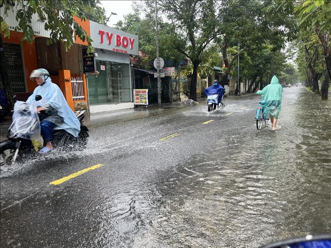
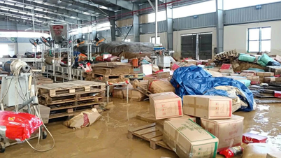
Heavy rains are concentrated along the coast, posing a risk of flash floods, landslides and inundation in low-lying areas. This rain is forecast to last until the end of October 2025, while many areas in the Central and Southern regions continue to record thunderstorms, strong winds and large waves at sea.
In addition, from the evening of October 24 to October 25, the area from Ha Tinh to Quang Tri, Khanh Hoa, Lam Dong provinces and the Southern region will have rain, moderate rain and thunderstorms with rainfall of 15-40mm, locally heavy to very heavy rain over 100mm. Warning of the risk of heavy rain over 60mm/3 hours.
From the evening of October 26 to the evening of October 27, the area from Quang Tri to Quang Ngai will have moderate rain, heavy rain and thunderstorms with common rainfall from 50-100mm, locally very heavy rain over 200mm. Disaster risk level due to heavy rain, tornadoes, lightning, hail: level 1.
According to information from the National Center for Hydro-Meteorological Forecasting, from 4:30 p.m. to 9:30 p.m., the area from Ha Tinh to Gia Lai will continue to have rain. There is a risk of flash floods and landslides in the above area.
Specifically, the cumulative rainfall is generally from 10-20mm, in some places over 50mm. Risk warning: flash floods on small rivers and streams, landslides on steep slopes in many communes/wards:
Cam Lac, Huong Khe, Ky Anh, Ky Hoa, Ky Khang, Ky Xuan, Hoanh Son, Vung Ang; Ky Van, Hai Ninh, Song Tri (Ha Tinh province); Hai Lang; Ai Tu, Ba Long, Dakrong, La Lay, Quang Tri, Ta Rut, Trieu Phong (Quang Tri province);
Binh Dien, Hung Loc, Huong An, Huong Tra, Kim Long, Kim Tra, Phong Thai, Phu Bai; A Luoi 5, Loc An, Nam Dong, Phong Dien, Phu Loc, Vinh Loc, A Luoi 1, A Luoi 2, A Luoi 3, A Luoi 4, Chan May - Lang Co, Khe Tre, Long Quang (Hue city);
Avuong, Ba Na, Dong Giang, Hoa Vang, Nong Son, Hai Van, Son Tra, Song Vang; Dai Loc, Duy Xuyen, Ha Nha, An Khe, Hoa Khanh, Que Phuoc, Son Cam Ha, Song Kon, Tam My, Tay Giang, Tay Ho, Thang Phu, Tra Giap, Tra Leng, Tra Lien (Da Nang city);
Ba Vinh, Thanh Bong; Ba Dinh, Ba Dong, Ba To, Ba To, Ba Vi, Dang Thuy Tram, Khanh Cuong, Kon Plong, Mang But, Minh Long, Nguyen Nghiem, Duc Pho, Sa Huynh, Son Linh, Son Tay, Son Thuy, Thien Tin (Quang Ngai province);
An Hoa, An Tuong, Hoai An, Bong Son Ward; An Hao, An Lao, An Toan, An Vinh, Hoai Nhon, Hoai Nhon Bac, Hoai Nhon Dong, Hoai Nhon Nam, Hoai Nhon Tay, Tam Quan, Phu My Bac, Phu My Tay, Van Duc (Gia Lai province).
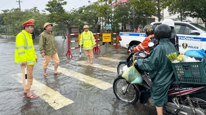
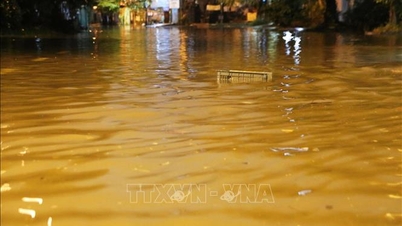
The National Center for Hydro-Meteorological Forecasting predicts that from October 24 to October 28, a flood will occur on rivers from Quang Tri to Quang Ngai. During this flood, the peak water level on Kien Giang River, Thach Han River (Quang Tri), Bo River, Huong River (Hue City), Vu Gia - Thu Bon River (Da Nang City), Tra Khuc River, Ve River (Quang Ngai) will reach alert level 1 - alert level 2, some places above alert level 2.
There is a high risk of widespread flooding in the provinces from Quang Tri to Quang Ngai, a high risk of flash floods on rivers and streams and landslides on steep slopes in the provinces from Quang Tri to Quang Ngai. Flood risk level 1-2
In addition, in the next 24 - 72 hours, the water level in the eastern coast of the South will continue to change slowly. The highest water level at Vung Tau station is likely to reach 4.05 - 4.1m.
Due to the impact of high tides, the eastern coastal area of the South needs to pay attention to prevent high risks of flooding and dike overflow in low-lying coastal and riverside areas, outside the dike, affecting traffic, agricultural production, aquaculture, water pollution and people's lives in the eastern coastal area of the South.
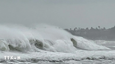
Weather forecast at sea, on the night of October 24 and October 25, the North East Sea area (including Hoang Sa special zone) has strong winds of level 6, sometimes level 7, gusts of level 8-9, rough seas, waves 3-5m high.
Sea area from South Quang Tri to Quang Ngai strong wind level 6, gust level 8, rough sea, waves 2-4m high
Gulf of Tonkin wind level 5, sometimes level 6, gust level 7-8, rough sea, waves 2-3m high
In addition, on the night of October 24 and 25, the sea area from Hue city to Ca Mau, from Ca Mau to An Giang, the Gulf of Thailand, the sea area south of the North East Sea (including Hoang Sa special zone), the area between the East Sea and the South East Sea (including Truong Sa special zone) will have scattered showers and thunderstorms, with the possibility of tornadoes, strong gusts of wind of level 6-7 and waves over 2m high.
Night of October 25 and 26: The northern sea area of the North East Sea has strong northeast winds of level 6, sometimes level 7, gusting to level 8-9, rough seas, waves 3-5m high.
In the Gulf of Tonkin, the Northeast wind gradually increases to level 6, gusting to level 7-8, rough seas, waves 2-4m high.
The sea area from South Quang Tri to Quang Ngai has strong northeast wind level 6, gusting to level 7-8, rough sea, waves 2.5 - 4.5m high.
Marine disaster risk level 2.
All vessels operating in the above areas are at high risk of being affected by strong winds and large waves.
Regarding the weather in the regions on the night of October 24 and October 25, the Northwest region will have rain in some places, cold at night and in the morning, light wind. The lowest temperature is 18-21 degrees Celsius, some places below 17 degrees Celsius. The highest temperature is 24-27 degrees Celsius, some places above 27 degrees Celsius.
In the Northeast, there will be rain in some places, cold weather, and in mountainous areas, it will be freezing. Northeast wind level 2-3. Lowest temperature 18-21 degrees Celsius, in mountainous areas, below 17 degrees Celsius. Highest temperature 23-26 degrees Celsius.
Hanoi has rain in some places, cold weather. Northeast wind level 2-3. Lowest temperature 19-21 degrees Celsius. Highest temperature 23-25 degrees Celsius.
Provinces from Thanh Hoa to Hue, at night there will be rain, moderate rain, locally heavy rain; during the day there will be scattered rain; in Hue city alone there will be moderate rain, heavy rain, locally very heavy rain, cold weather. North to Northwest wind level 2-3. Lowest temperature 18-21 degrees Celsius. Highest temperature 22-25 degrees Celsius.
The South Central Coast, the North (from Da Nang to the East of Dak Lak) has moderate rain, heavy rain, locally very heavy rain and thunderstorms; the South is cloudy, scattered showers and thunderstorms, locally heavy rain, with the possibility of tornadoes, lightning and strong gusts of wind in thunderstorms. Northeast wind level 2-3. Lowest temperature 23-26 degrees Celsius, highest temperature in the North 26-29 degrees Celsius, in the South 29-31 degrees Celsius.
The Central Highlands has scattered showers and thunderstorms in some places; in the afternoon and evening there will be scattered showers and thunderstorms in some places, with the possibility of tornadoes, lightning, hail and strong gusts of wind. Northeast wind level 2-3. Lowest temperature 19-22 degrees Celsius. Highest temperature 27-30 degrees Celsius, some places over 30 degrees Celsius.
The South has scattered showers and thunderstorms; in the afternoon and at night there is rain, moderate rain and scattered thunderstorms, locally heavy to very heavy rain, with the possibility of tornadoes, lightning, hail and strong gusts of wind. Northeast to East wind level 2-3. Lowest temperature 23-26 degrees Celsius. Highest temperature 30-33 degrees Celsius, some places above 33 degrees Celsius.
Ho Chi Minh City has showers and thunderstorms in some places; in the afternoon and at night there is rain, moderate rain and scattered thunderstorms, locally heavy to very heavy rain in some places, in thunderstorms there is a possibility of tornadoes, lightning, hail and strong gusts of wind. Northeast to East wind level 2-3. Lowest temperature 24-26 degrees Celsius. Highest temperature 31-33 degrees Celsius.
Source: https://baotintuc.vn/van-de-quan-tam/tu-hue-den-quang-ngai-co-noi-mua-tren-300mm-nguy-co-ngap-ung-va-sat-lo-dat-20251024172556141.htm

![[Photo] Prime Minister Pham Minh Chinh receives United Nations Secretary-General Antonio Guterres](https://vphoto.vietnam.vn/thumb/1200x675/vietnam/resource/IMAGE/2025/10/25/1761390212729_dsc-1484-jpg.webp)

![[Photo] National Assembly Chairman Tran Thanh Man receives United Nations Secretary-General Antonio Guterres](https://vphoto.vietnam.vn/thumb/1200x675/vietnam/resource/IMAGE/2025/10/25/1761390815792_ctqh-jpg.webp)
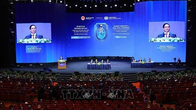
![[Photo] Prime Minister Pham Minh Chinh and United Nations Secretary-General Antonio Guterres attend the Press Conference of the Hanoi Convention Signing Ceremony](https://vphoto.vietnam.vn/thumb/1200x675/vietnam/resource/IMAGE/2025/10/25/1761391413866_conguoctt-jpg.webp)


![[Photo] General Secretary To Lam meets with General Secretary and President of Laos Thongloun Sisoulith](https://vphoto.vietnam.vn/thumb/1200x675/vietnam/resource/IMAGE/2025/10/25/1761380913135_a1-bnd-4751-1374-7632-jpg.webp)


Comment (0)