
In Dong Thap province, where the Tien River meanders through many residential areas, landslides are becoming increasingly frequent, sweeping away land and houses, causing significant property damage, and directly affecting the lives and livelihoods of the people. Faced with the increasingly complex nature of landslides, the Dong Thap provincial government has been implementing numerous emergency response measures, while also outlining fundamental and sustainable steps to protect the safety of residents, infrastructure, and agricultural production along the riverbanks. This two-part series, "Alarming Landslide Situation and Fundamental Solutions," reflects the overall picture of the serious landslide situation in Dong Thap province, while also acknowledging the local efforts and solutions in addressing, preventing, and managing natural disaster risks in the coming period.
Lesson 1: Landslides are rampant
In just 10 months of 2025, Dong Thap province recorded more than 150 riverbank and canal erosion points with a total length of nearly 20 km, causing heavy damage to property and threatening the safety and lives of people. Many areas that were once fertile alluvial plains have now become serious erosion "hotspots".
From the Tien and Hau rivers to the inland canals, erosion not only distorts the landscape and sweeps away houses and gardens, but also leaves people living in constant insecurity. This situation highlights the alarming extent of geological changes, water flow, and the consequences of uncontrolled production and construction activities over the past years.
Heavy damage
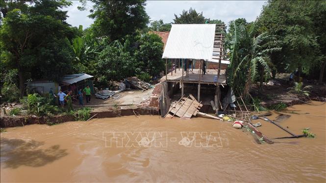
Upstream along the Tien River, the Thuong Thoi Tien embankment area (Thuong Phuoc commune, Dong Thap province) was previously a place of alluvial soil. However, it is now a severely eroded area. In the past two months, seven sections of the Thuong Thoi Tien embankment have experienced landslides and subsidence, totaling over 480 meters in length, causing the embankment slopes to collapse, the pavement to sink, and encroaching into the road.
The Thuong Thoi Tien embankment, part of the "Drought and Flood Risk Management and Mitigation Project in the Greater Mekong Subregion," has a total length of 4,065 meters, divided into three phases with a budget of hundreds of billions of VND. Of these, phase 1, 2,765 meters long, was completed and handed over for use in March 2017; phase 2 (460 meters) and phase 3 (840 meters) were both completed and handed over for use in October 2019.
Recently, on the evening of October 13th, a landslide occurred on the banks of the Tien River in Tan Quoi hamlet, Tan Long commune (Dong Thap province). While there were no casualties, the landslide resulted in the loss of approximately 600 square meters of land and some property. According to the Tan Long Commune Civil Defense Command, the landslide extended 30 meters in length and about 20 meters inland, submerging a temporary house (kitchen) and several crops such as tamarind, acacia, bamboo, and mango trees into the Tien River. Currently, 11 households with over 40 people are living in the affected area.
Mr. Tran Van Ham, residing in Tan Quoi hamlet, Tan Long commune, stated that a landslide occurred right behind his house, causing his kitchen (where he cooked) to collapse into the Tien River. For about three years now, the area where Mr. Ham lives has experienced numerous landslides. In 2024, his family's fish pond collapsed into the Tien River, and this year, another landslide destroyed his kitchen.
Previously, a landslide occurred on the banks of the Tien River more than 500 meters from Mr. Ham's house. Now, the area looks desolate, with most of the sturdy houses sinking into the Tien River. Homeowners are trying to salvage and dismantle what remains (front doors, windows, corrugated iron roofs, etc.). "Three years ago, my house was about 30 meters from the Tien River. But the landslide attacked right up to my house, so I had to move it forward to 'escape the landslide'. But now, the house has moved right up to the road. If the landslide continues, I don't know where I'll live," shared Mr. Nguyen Thanh Dien from Thuong Hamlet, Tan Long Commune.
Further downstream on the Tien River, the riverbank erosion situation is also extremely complex. Due to heavy rain and rapidly rising floodwaters, combined with a high volume of waterway traffic, on September 20th and 24th, the Tien River bank along Nguyen Huong Street (Tan Tich and Tinh Hung hamlets, Cao Lanh ward) experienced erosion along a total length of approximately 500 meters, extending 30-70 meters inland. Although the erosion did not cause any casualties, it damaged the property of 35 households, with houses and land collapsing into the Tien River. The remaining section, approximately 1,600 meters long, is at risk of further erosion at any time, affecting the safety and property of about 285 households with over 900 people.
According to Bui Quoc Nam, Chairman of the People's Committee of Cao Lanh Ward, immediately after the landslide occurred, the People's Committee directed relevant agencies to assist residents in relocating their property and belongings, and encouraged some households in nearby areas at high risk of landslides to raise their vigilance and proactively respond. In addition, the local authorities mobilized businesses and philanthropists to provide timely support to affected households. In the future, the People's Committee will study policy solutions in accordance with the law to provide the best possible support for the affected households, helping them to stabilize their lives as soon as possible.
Identify the cause
Mr. Nguyen Duc Thinh, Deputy Director of the Department of Agriculture and Environment of Dong Thap province, said that the landslides in the province are occurring rapidly, with many landslide points and a serious level of severity compared to previous periods. Scientific reports and practical observations have identified the basic causes of coastal and riverbank erosion.
Regarding riverbank erosion in the Tien and Hau rivers, the main cause in the province is the dynamic flow impacting the riverbed's soft and weak geological structure, leading to erosion. Erosion often occurs in areas with islets and where the river branches, at the confluence of river branches, in sections of the river with unstable channels, and where the river is narrow or has bottlenecks. In addition, human activities such as aquaculture along riverbanks without proper planning or guidance from relevant authorities, and the construction of houses and businesses encroaching on the river surface, narrowing the riverbed's wet cross-section, as well as waves and wind caused by watercraft, also contribute to localized erosion.
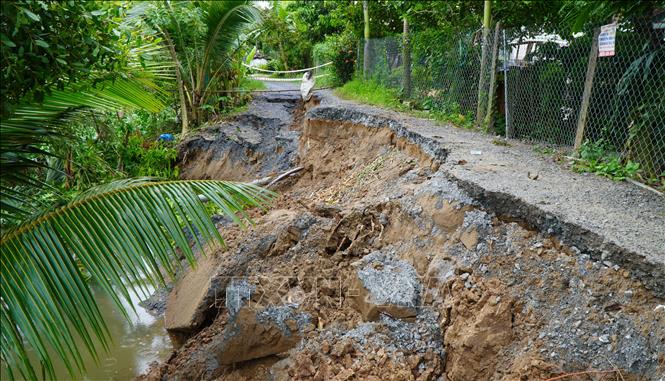
As for erosion in inland canals and ditches, the high density of rivers and canals, with many curved sections and numerous junctions, makes them vulnerable to erosion. The direct flow of water against the banks over time creates cavities, combined with low tides, heavy early-season rains, and the constant flow of watercraft, all of which contribute to erosion.
The number of dikes and embankments combined with rural roads is increasing rapidly, often running parallel to canals and ditches without ensuring adequate clearance. When investing in upgrading these dikes combined with roads, most localities implement the solution of excavating and pumping sand, which disrupts the soil structure. Simultaneously, the high traffic density causes road surface subsidence and landslides.
Furthermore, the construction of numerous houses and infrastructure projects too close to riverbanks, such as dikes, roads, and construction material yards, or structures encroaching on riverbeds, canals, and ditches, narrows or diverts the flow, thereby increasing the risk of bank erosion.
Immediately after the landslide occurred, the People's Committee of the commune/ward in Dong Thap province directed the Department of Economic Infrastructure and Urban Planning to coordinate with the village head and relevant units to conduct a field survey of the landslide site, erect warning signs about the landslide, and place signs prohibiting tricycles and cars from passing through the landslide area. They also encouraged households in the area to build embankments and fill in the land to widen the road on the inside to allow people to temporarily pass through the landslide area. At the same time, they directed relevant departments to carry out temporary reinforcement to limit the landslide from further encroaching further inland.
Specifically in Hoi Cu commune, Dong Thap province, the situation of riverbank erosion is very complex, especially along Canal 28, with a section of erosion approximately 100 meters long. Mr. Nguyen Van Nhiem, Secretary of the Party Committee and Chairman of the People's Committee of Hoi Cu commune, Dong Thap province, said: The locality has temporarily reinforced the eroded areas to prevent tidal surges from affecting the fruit orchards of the people, and at the same time requested the Provincial People's Committee to support the locality in overcoming the erosion situation in the area.
For the time being, the local authorities have set up barricades and warned people not to pass through the landslide area, but to use other safe routes while waiting for the province to allocate funds for thorough, coordinated, and complete remediation.
Final article: Review and develop a sustainable master plan.
Source: https://baotintuc.vn/kinh-te/bao-dong-tinh-trang-sat-lo-va-giai-phap-can-co-bai-1-sat-lo-bua-vay-20251025105420054.htm

![[Photo] Prime Minister Pham Minh Chinh holds a phone call with the CEO of Russia's Rosatom Corporation.](/_next/image?url=https%3A%2F%2Fvphoto.vietnam.vn%2Fthumb%2F1200x675%2Fvietnam%2Fresource%2FIMAGE%2F2025%2F12%2F11%2F1765464552365_dsc-5295-jpg.webp&w=3840&q=75)

![[Photo] Closing Ceremony of the 10th Session of the 15th National Assembly](/_next/image?url=https%3A%2F%2Fvphoto.vietnam.vn%2Fthumb%2F1200x675%2Fvietnam%2Fresource%2FIMAGE%2F2025%2F12%2F11%2F1765448959967_image-1437-jpg.webp&w=3840&q=75)


![[OFFICIAL] MISA GROUP ANNOUNCES ITS PIONEERING BRAND POSITIONING IN BUILDING AGENTIC AI FOR BUSINESSES, HOUSEHOLDS, AND THE GOVERNMENT](https://vphoto.vietnam.vn/thumb/402x226/vietnam/resource/IMAGE/2025/12/11/1765444754256_agentic-ai_postfb-scaled.png)


Comment (0)