

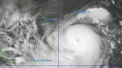
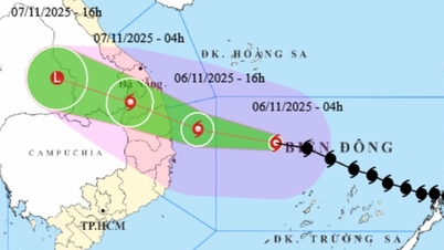
It is forecasted that by 1 p.m. on November 4, the storm will move mainly westward at a speed of about 25 km/h, with its center at about 10.9 degrees North latitude; 122.2 degrees East longitude, in the central Philippines. The storm intensity is level 12, gusting to level 15.
At 1 p.m. on November 5, the storm moved in a West-Northwest direction at a speed of 20-25 km/h and entered the East Sea. The center of the storm was located at about 12.0 degrees North latitude; 117.6 degrees East longitude, in the sea area east of the central East Sea.
The storm is likely to intensify, reaching level 13, gusting to level 16. The danger zone is between latitude 10.00 and 15.00 degrees North, east of longitude 115.50 degrees East. Disaster risk level 3: the central East Sea area (including Truong Sa special zone).
The storm is likely to intensify, reaching level 14, gusting to level 17. The danger zone is between latitude 10.00 and 16.50 degrees North, east of longitude 110.00 degrees East. Disaster risk level 4: the central East Sea area (including Truong Sa special zone), the sea area from Da Nang to Khanh Hoa.
Storm impact forecast: Strong winds, big waves: At sea, from around the afternoon of November 4, the sea area east of the central East Sea will have winds gradually increasing to level 6-7, then increasing to level 8-9; near the storm center, strong winds of level 10-12, gusts of level 14-15, waves 5.0-7.0m high, rough seas.
Source: https://baohaiphong.vn/bao-kalmaegi-dang-tien-nhanh-vao-bien-dong-co-kha-nang-manh-len-cap-14-525487.html


![[Photo] Opening of the 14th Conference of the 13th Party Central Committee](https://vphoto.vietnam.vn/thumb/1200x675/vietnam/resource/IMAGE/2025/11/05/1762310995216_a5-bnd-5742-5255-jpg.webp)


Comment (0)