
The Department of Education and Training of Ho Chi Minh City has requested heads of educational institutions to focus on implementing preventive and response measures when storm Kalmaegi affects the Ho Chi Minh City area; and prepare plans to respond to the storm's impacts, especially thunderstorms, tornadoes, landslides, and flooding caused by heavy rain combined with high tides.
Facilities urgently repair and reinforce structures at risk of being unsafe, coordinate with specialized units to trim trees inside schools, check sewer systems, drainage ditches, and power grids to ensure safety for students, teachers, and administrators before storms and floods occur.

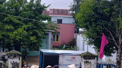
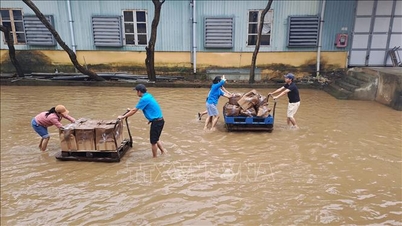
Military forces support schools in moving assets (Photo: Xuan Dien).
Along with that, educational institutions need to prepare plans to evacuate students and teachers to safe places; move documents and equipment to dry locations before storms and floods.
The Department requires schools to proactively coordinate with local authorities to receive support in terms of expertise, materials, and equipment when situations arise.
Along with that, it is necessary to closely monitor the development of storms and rains, maintain regular contact with authorities and local rescue forces to promptly respond in case of incidents.
The Department also requires educational institutions to have plans ready for online learning and postpone class schedules during complicated stormy days (if any).
Immediately after the storm, units need to urgently repair damage; clean and sanitize schools and classrooms to ensure safety, cleanliness, and prevent epidemics at the unit.
On the other hand, it is necessary to proactively coordinate with the local Steering Committee for Natural Disaster Prevention and Search and Rescue to organize propaganda for teachers, students and parents on disaster response skills, first aid and ensuring safety in emergency situations.
“Temporarily suspend extracurricular educational activities for students before, during and after the storm until safety measures return to normal,” the Ho Chi Minh City Department of Education and Training requested.

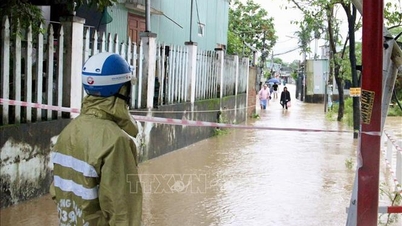
Ho Chi Minh City requires schools to prepare online learning plans to avoid storms (Illustration: Tran Dai Nghia).
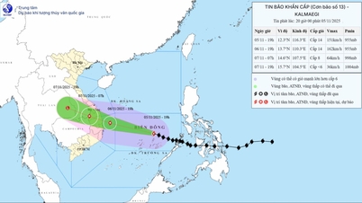
After entering the East Sea early this morning (November 5), storm Kalmaegi is showing signs of strengthening. It is forecasted that by tomorrow afternoon, the storm will increase one level, reaching level 14, gusting to level 17.
According to the National Center for Hydro-Meteorological Forecasting at 1:00 p.m. on November 5, the center of storm Kalmaegi (storm No. 13) was about 360 km east of Song Tu Tay Island. The strongest wind near the center of the storm was level 13-14 (133-166 km/h), gusting to level 17.
In the next 24 hours, the storm will move west at a fast speed of about 25km/h.
At 1:00 p.m. on November 6, the storm was about 290km east-southeast of Quy Nhon ( Gia Lai ) with a level 14 intensity, gusting to level 17 and likely to strengthen, moving mainly in the West-Northwest direction at a fast speed of about 25km/h.
At 1:00 a.m. on November 7, the storm on the mainland along the Quang Ngai - Dak Lak coast with intensity of level 12, gusting to level 15, moved mainly in the West Northwest direction at a speed of about 25km/h and went deep inland.
At 1 p.m. on November 7, the storm was on land in southern Laos and gradually weakened into a tropical depression with a level 6 intensity, gusting to level 8.
The Japan Meteorological Agency said that the strongest wind speed near the center of typhoon Kalmaegi is currently up to 138 km/h. The station forecasts that by the afternoon of November 6, the storm will reach its peak with winds of up to 158 km/h and then gradually weaken.
Source: https://dantri.com.vn/giao-duc/so-gddt-tphcm-yeu-cau-cac-truong-len-phuong-an-so-tan-hoc-sinh-khi-co-bao-20251105171239465.htm


![[Photo] Opening of the 14th Conference of the 13th Party Central Committee](https://vphoto.vietnam.vn/thumb/1200x675/vietnam/resource/IMAGE/2025/11/05/1762310995216_a5-bnd-5742-5255-jpg.webp)


![[Photo] Panorama of the Patriotic Emulation Congress of Nhan Dan Newspaper for the period 2025-2030](https://vphoto.vietnam.vn/thumb/1200x675/vietnam/resource/IMAGE/2025/11/04/1762252775462_ndo_br_dhthiduayeuncbaond-6125-jpg.webp)


Comment (0)