
 |
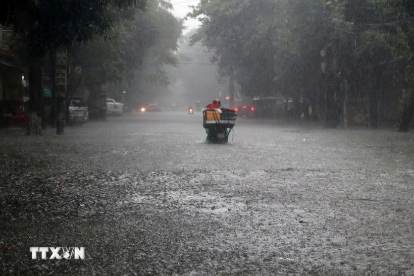
| Heavy rain caused many roads in Nghe An to be severely flooded. (Photo: VNA) |
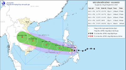
According to the National Center for Hydro-Meteorological Forecasting, storm Kalmaegi is intensifying, heading towards the central East Sea.
Accordingly, at 1:00 a.m. on November 3, the center of storm Kalmaegi was at about 11.2 degrees North latitude; 129.7 degrees East longitude, in the sea east of central Philippines.
The strongest wind near the storm center is level 11 (103-117 km/h), gusting to level 14. Moving west at a fast speed of about 30 km/h.
At 1:00 a.m. on November 4, the storm in the eastern central region of the Philippines with strong winds of level 12, gusts of level 15, moving mainly west at a speed of about 20 km/h and likely to strengthen.
Then, at 1:00 a.m. on November 5, the storm in the western central Philippines with strong winds of level 12, gusts of level 15 moved mainly in the West Northwest direction at a speed of about 20-25 km/h. The affected area is the sea area east of the central East Sea. Disaster risk level 3.
Next, at 1:00 a.m. on November 6, the storm in the central East Sea with strong winds of level 13, gusts of level 17, moving in the West Northwest direction at a speed of about 20 km/h and likely to strengthen. The affected area is the central East Sea (including Truong Sa special zone). Disaster risk level 3.
From the next 72 to 120 hours, the storm will move mainly in the West-Northwest direction, about 20-25 km per hour and is likely to strengthen.
Due to the impact of the storm, from around the afternoon of November 4, the sea area east of the central East Sea will have winds gradually increasing to level 6-7, then increasing to level 8-9; the area near the storm center will have strong winds of level 10-12, gusts of level 14-15, waves 5-7m high, and rough seas.
Warning: Around November 5-6, the central East Sea area (including Truong Sa special zone), the sea area off the coast of Da Nang - Khanh Hoa is likely to be affected by strong winds of level 12-14, gusts above level 17, waves 8-10m high, and rough seas.
All ships and structures operating in the above-mentioned dangerous areas are strongly affected by storms, whirlwinds, strong winds and big waves.
Cold air strengthens, causing rain in the North and North Central regions
The National Center for Hydro-Meteorological Forecasting said that cold air has affected the Northeast region, some places in the Northwest and North Central regions. At Bach Long Vy station, there are strong Northeast winds of level 6, sometimes level 7, gusting to level 8.
It is forecasted that on November 3, cold air will continue to affect other places in the Northwest and North Central regions. After that, the cold air will continuously strengthen, expanding the area of influence to some places in the Central Central region. On land, strong northeast winds will be at level 2-3, and coastal areas will be at level 3-4.
Due to the influence of the cold air, from November 3-4, the North, Thanh Hoa and the North of Nghe An will have rain in many places, cold weather, and some places in the high mountains of the North will be very cold. The lowest temperature during this cold air mass in the North, Thanh Hoa and Nghe An will generally be from 16-19 degrees Celsius, and some places in the mountains will be below 15 degrees Celsius.
Due to the strengthening of cold air combined with disturbances in the upper easterly wind zone, the area from the south of Nghe An to Quang Ngai continues to have widespread heavy rain.
Hanoi area from November 3-4 will have rain and cold weather. The lowest temperature in this cold air mass is commonly 17-19 degrees Celsius.
At sea, in the Gulf of Tonkin, the Northeast wind is level 6, sometimes level 7, gusting to level 8, rough seas, waves 2-3.5m high; in the North East Sea, the Northeast wind is strong at level 6-7, gusting to level 8-9, rough seas, waves 3-5m high.
Cold weather can affect livestock and poultry and the growth and development of crops.
Heavy rain can cause flooding in low-lying areas; flash floods in small rivers and streams, landslides on steep slopes; heavy rain in a short period of time can cause flooding in urban areas and industrial zones.
Strong winds and gusts, large waves at sea are likely to affect boating and other activities.
 |
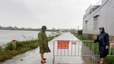
| Hue residents are busy cleaning up their houses after the flood. (Photo: Hai Au/VNA) |
Heavy rain from South Nghe An to Quang Ngai
The National Center for Hydro-Meteorological Forecasting predicts that from early morning of November 3 to the end of November 4, the area from Ha Tinh to Da Nang city and the East of Quang Ngai province will have heavy to very heavy rain with rainfall in the area from South Quang Tri to Da Nang city generally 200-300mm, locally over 600mm.
In Ha Tinh, Northern Quang Tri and Eastern Quang Ngai provinces, rainfall is generally 100-200mm, locally over 350mm. In Southern Nghe An and Western Quang Ngai provinces, there is moderate to heavy rain with rainfall generally 60-120mm, locally over 200mm. Warning of the risk of heavy rain over 200mm/3 hours.
In addition, during the day and night of November 3, in the Central Highlands and the South, there will be scattered showers and thunderstorms with rainfall of 10-30mm, with some places experiencing heavy rain over 60mm (rain concentrated in the afternoon and evening). Warning of the risk of heavy rain over 60mm/3 hours.
Warning: On the night of November 4, the area from Ha Tinh to Da Nang city will have moderate to heavy rain with common rainfall of 20-40mm, locally very heavy rain of over 70mm. From November 5 to the morning of November 6, heavy rain in the above area will tend to decrease gradually.
Natural disaster risk level due to heavy rain, tornadoes, lightning, and hail is level 1; in the area from South Quang Tri to Da Nang city, level 2.
Heavy rains are likely to cause flooding in low-lying areas, urban and industrial areas; flash floods on small rivers and streams, landslides on steep slopes (real-time warning information on areas at risk of flash floods and landslides is provided online on the website of the Department of Hydrometeorology at: https://luquetsatlo.nchmf.gov.vn and in a separate bulletin warning of flash floods and landslides). During thunderstorms, there is a possibility of tornadoes, lightning, hail and strong gusts of wind.
Floods on Vu Gia-Thu Bon River continue to rise
According to information from the National Center for Hydro-Meteorological Forecasting, from 4:30 a.m. to 1:30 p.m. on November 3, floods on the Vu Gia-Thu Bon River continued to rise and were above alert level 3; floods on the Huong River and Bo River fluctuated below alert level 3.
In the next 12-24 hours, flood on Vu Gia river will gradually decrease and be above alert level 3, Huong river, Bo river, Thu Bon river will be below alert level 3.
In the next 24 hours, flood on Ngan Sau River will change slowly and stay below alert level 2.
From now until November 5, floods on rivers in Ha Tinh, Quang Tri, and Quang Ngai are likely to rise again. During this flood, peak water levels on Ngan Sau and Ngan Pho rivers (Ha Tinh), Gianh, Kien Giang, Thach Han (Quang Tri), and Tra Khuc (Quang Ngai) will reach alert level 2-3, with some rivers above alert level 3.
Warning of flood risk in low-lying areas along rivers, urban areas, and densely populated areas in provinces from Ha Tinh to Quang Ngai. High risk of flash floods on rivers and streams and landslides on slopes in provinces/cities from Ha Tinh to Quang Ngai. Flood risk level 3.
Floods on rivers and inundation in low-lying areas affect activities such as water transport, aquaculture, agricultural production, people's lives and socio-economic activities.
"The forecast and warning information is calculated based on the expected operating level of upstream reservoirs. The hydrometeorological agency will update the bulletins when there are changes in the discharge flow of the reservoirs," noted Hoang Van Dai, Deputy Director of the National Center for Hydrometeorological Forecasting.
 |
| According to the National Center for Hydro-Meteorological Forecasting, this cold spell is just the beginning of a series of early cold days this year. The cold air is forecast to intensify in late October and early November, with the lowest temperature likely to drop below 17 degrees Celsius at night. The deepest drop is expected to fall between December 2025 and January 2026. (Photo: Minh Son/Vietnam+) |
Weather in regions day and night 11/3
- The Northwest has rain, cold weather, some places are very cold; Dien Bien-Lai Chau is cold. Light wind. Lowest temperature 16-19 degrees Celsius, some places below 15 degrees Celsius. Highest temperature 19-22 degrees Celsius, Lai Chau-Dien Bien 22-25 degrees Celsius.
- The Northeast region has rain and cold weather, some mountainous areas have severe cold. Northeast wind level 2-3, coastal areas level 3-4. Lowest temperature 16-19 degrees Celsius, some mountainous areas below 15 degrees Celsius. Highest temperature 19-22 degrees Celsius.
- Hanoi city has rain, northeast wind level 2-3, cold weather. Lowest temperature 17-19 degrees Celsius. Highest temperature 19-21 degrees Celsius.
- Provinces and cities from Thanh Hoa to Hue have moderate to heavy rain, locally very heavy rain and thunderstorms; especially the area from Ha Tinh to Hue city has heavy to very heavy rain, with the possibility of tornadoes, lightning and strong gusts of wind during thunderstorms. North to Northwest wind level 2-3, coastal areas level 3-4. In the North, it is cold. Lowest temperature 19-22 degrees Celsius. Highest temperature in the North 21-23 degrees Celsius, in the South 24-26 degrees Celsius.
- South Central Coast, North has heavy to very heavy rain and thunderstorms; South has scattered showers and thunderstorms, in the afternoon and evening there are scattered showers and thunderstorms, locally heavy rain, in thunderstorms there is a possibility of tornadoes, lightning and strong gusts of wind. In the North, East to Northeast wind level 2-3, in the South, Southwest wind level 2-3. Lowest temperature 22-25 degrees Celsius. Highest temperature in the North 25-28 degrees Celsius; in the South 29-32 degrees Celsius.
- The Central Highlands has scattered showers and thunderstorms, locally heavy rain (rain concentrated in the afternoon and evening), thunderstorms are likely to have tornadoes, lightning, hail and strong gusts of wind. Lowest temperature 18-21 degrees Celsius. Highest temperature 24-27 degrees Celsius.
- The South has scattered showers and thunderstorms, locally heavy rain (rain concentrated in the afternoon and night), thunderstorms are likely to have tornadoes, lightning, hail and strong gusts of wind. Southwest to West wind level 2-3. Lowest temperature 23-26 degrees Celsius. Highest temperature 30-33 degrees Celsius.
- Ho Chi Minh City has scattered showers and thunderstorms, locally heavy rain (rain concentrated in the afternoon and night), thunderstorms are likely to have tornadoes, lightning, hail and strong gusts of wind. Southwest to West wind level 2-3. Lowest temperature 24-26 degrees Celsius. Highest temperature 31-33 degrees Celsius.
According to VNA/Vietnam+
Source: https://baoquangtri.vn/xa-hoi/202511/bao-kalmaegi-tang-cap-huong-ve-khu-vuc-giua-bien-dong-a096e2e/

![[Photo] The road connecting Dong Nai with Ho Chi Minh City is still unfinished after 5 years of construction.](https://vphoto.vietnam.vn/thumb/1200x675/vietnam/resource/IMAGE/2025/11/04/1762241675985_ndo_br_dji-20251104104418-0635-d-resize-1295-jpg.webp)

![[Photo] Ca Mau "struggling" to cope with the highest tide of the year, forecast to exceed alert level 3](https://vphoto.vietnam.vn/thumb/1200x675/vietnam/resource/IMAGE/2025/11/04/1762235371445_ndo_br_trieu-cuong-2-6486-jpg.webp)
![[Photo] Ho Chi Minh City Youth Take Action for a Cleaner Environment](https://vphoto.vietnam.vn/thumb/1200x675/vietnam/resource/IMAGE/2025/11/04/1762233574890_550816358-1108586934787014-6430522970717297480-n-1-jpg.webp)
![[Photo] Panorama of the Patriotic Emulation Congress of Nhan Dan Newspaper for the period 2025-2030](https://vphoto.vietnam.vn/thumb/1200x675/vietnam/resource/IMAGE/2025/11/04/1762252775462_ndo_br_dhthiduayeuncbaond-6125-jpg.webp)


Comment (0)