
 |
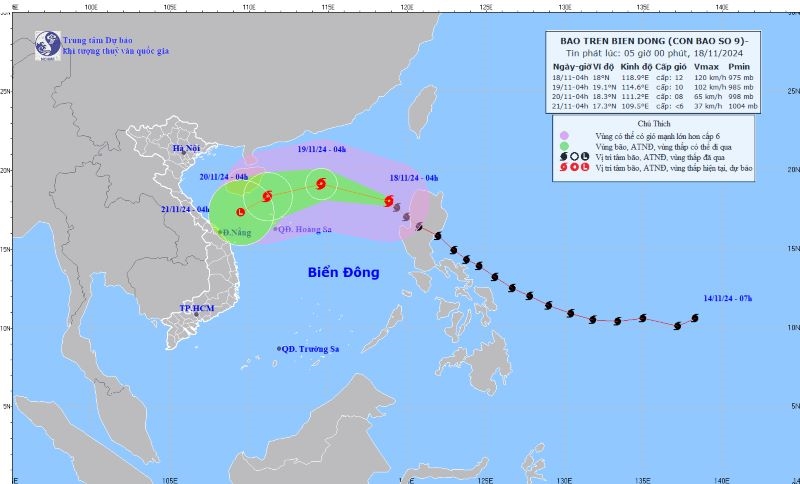
| Location and direction of storm No. 9 on the morning of November 18. Photo: Center for Hydro-Meteorological Forecasting |
According to the National Center for Hydro-Meteorological Forecasting, at 4:00 a.m. on November 18, the eye of the storm was located at about 18 degrees North latitude, 118.9 degrees East longitude, in the eastern sea of the North East Sea. The strongest wind near the eye of the storm was level 11-12 (103-133 km/h), gusting to level 15. The storm moved northwest at a speed of about 25 km/h.
At 4:00 a.m. on November 19, the center of the storm was at about 19.1 degrees North latitude, 114.6 degrees East longitude, in the North East Sea, about 370 km northeast of Hoang Sa. The strongest wind near the center of the storm was level 10, gusting to level 12. The storm moved in a West Northwest direction at a speed of about 20 km/h, continuing to weaken. The North East Sea has a level 3 natural disaster risk.
At 4:00 a.m. on November 20, the center of the storm was at about 18.3 degrees North latitude, 111.2 degrees East longitude, west of the North East Sea, about 210km northwest of Hoang Sa. The strongest wind near the center of the storm was level 8, gusting to level 10. The storm moved in a West Southwest direction at a speed of about 15km/h, continuing to weaken. The North East Sea (including the sea area north of Hoang Sa) had a level 3 natural disaster risk.
At 4:00 a.m. on November 21, the center of the storm was at about 17.3 degrees North latitude, 109.5 degrees East longitude, in the sea off the Central Central Coast. Wind force level 6. The storm moved southwest at a speed of about 10km/h, gradually weakening into a tropical depression, then a low pressure area. The western part of the North East Sea (including the sea northwest of Hoang Sa) has a level 3 natural disaster risk.
Northern and North Central regions have cold nights and mornings.
Information about cold air in the North, according to the National Center for Hydro-Meteorological Forecasting, on November 18, the cold air mass will affect some places in the Northeast region of the North; then to other places in the Northeast and North Central regions, some places in the Northwest and North Central regions. Northeast wind inland level 2-3, coastal areas level 3-4.
From the night of November 18, the Northeast and Thanh Hoa will have cold nights and early mornings; from November 20, the North and North Central regions will have cold nights and early mornings. The lowest temperature during this cold air mass in the North and North Central regions will generally be from 18-20 degrees Celsius, in mountainous areas, some places will be below 15 degrees Celsius.
Due to the influence of disturbances in the upper easterly wind zone combined with cold air, from November 18-19, the North and Central Central regions will have rain, showers and thunderstorms in some places, locally heavy rain in some places; thunderstorms may cause tornadoes, lightning and strong gusts of wind.
Impact of storm No. 9 and cold air, day and night of November 18, the North East Sea area (including Hoang Sa sea area) has Northeast wind, the East Sea area has wind from many directions level 6-7, gusting to level 8-9; especially the East Sea area has strong wind level 8-10, the area near the storm center has level 11-13, gusting to level 16. Waves are 3-5m high, the area near the storm center is 5-7m; the sea is very rough.
On the night of November 18, the Gulf of Tonkin had northeast winds of level 6, gusting to level 7-8. Waves were 1.5-2.5m high; rough seas; the risk of natural disasters due to strong winds at sea was level 2, especially in the eastern sea area of the North East Sea at level 3. All vessels operating in the above areas are at high risk of being affected by tornadoes, strong winds and large waves.
Weather in the regions during the day and night of November 18, the Northwest region is cloudy, sunny during the day, and has rain in some places at night. Early mornings and nights are cold, with some places getting cold. The lowest temperature is from 19-22 degrees Celsius, with some places below 18 degrees Celsius. The highest temperature is from 27-30 degrees Celsius, with some places above 30 degrees Celsius.
Northeast region is cloudy, with rain in some places. Northeast wind level 2-3, coastal areas level 3-4. Early morning and night are cold, some mountainous areas are cold. Lowest temperature is from 19-22 degrees Celsius, some mountainous areas are below 18 degrees Celsius. Highest temperature is from 26-29 degrees Celsius, some places are above 29 degrees Celsius.
Hanoi capital is cloudy, with rain in some places. Northeast wind level 2-3. Early morning and night are cold. Lowest temperature from 20-22 degrees Celsius. Highest temperature from 27-29 degrees Celsius, some places above 29 degrees Celsius.
Provinces from Thanh Hoa to Thua Thien - Hue are cloudy, with rain, showers and thunderstorms in some places, locally heavy rain in some places. North to Northwest wind level 2-3. Lowest temperature from 20-23 degrees Celsius. Highest temperature from 26-29 degrees Celsius.
Provinces and cities from Da Nang to Binh Thuan, the North is cloudy with rain, showers and thunderstorms in some places, locally heavy rain in some places; the South is cloudy, sunny during the day, showers and thunderstorms at night in some places. Northeast wind level 2-3. Lowest temperature, North 21-24 degrees Celsius, South 22-26 degrees Celsius. Highest temperature from 28-31 degrees Celsius.
The Central Highlands region is cloudy, sunny during the day, with showers and thunderstorms at night in some places. Northeast wind level 2-3. Lowest temperature from 19-22 degrees Celsius. Highest temperature from 28-31 degrees Celsius, some places above 31 degrees Celsius.
Southern region is cloudy, sunny during the day, with showers in some places in the evening and at night; sunny during the day. East to Northeast wind level 2-3. Lowest temperature from 23-26 degrees Celsius. Highest temperature from 31-34 degrees Celsius./.
Source: https://dangcongsan.vn/xa-hoi/bao-man-yi-vao-bien-dong-tro-thanh-bao-so-9-683495.html


Comment (0)