
(QNgTV)- On the evening of September 26, storm Bualoi entered the eastern sea of the central East Sea and became storm number 10 in 2025.
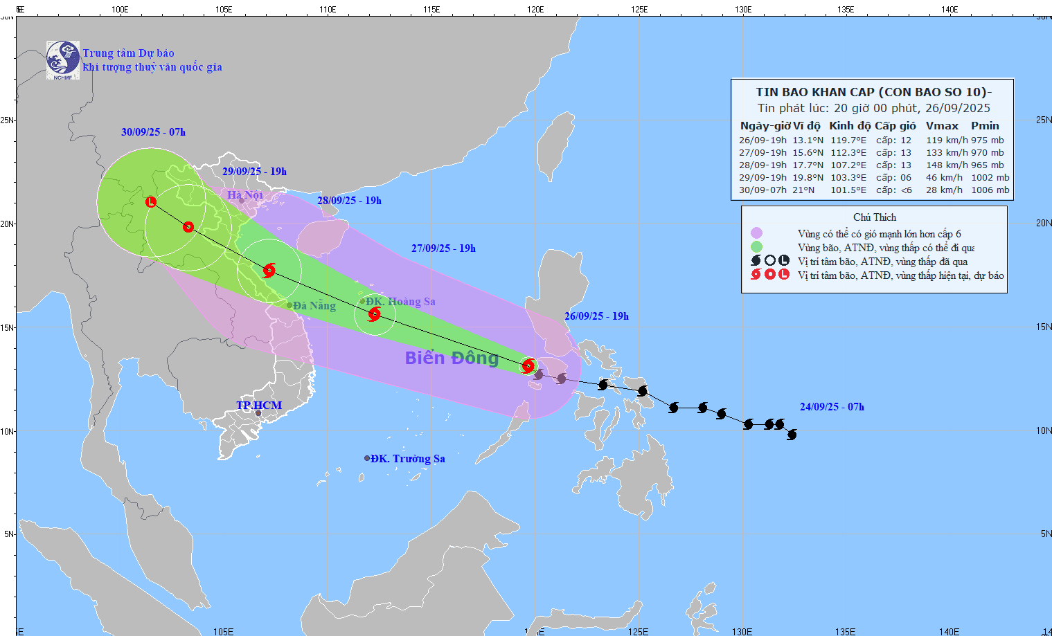
According to the latest update from the National Center for Meteorological and Hydrological Forecasting at 7 PM, the typhoon's center was located at approximately 13.1 degrees North latitude and 119.7 degrees East longitude, about 900 km southeast of the Hoang Sa Special Economic Zone. The strongest winds near the center of the typhoon were at level 11-12 (103-133 km/h), with gusts up to level 15. The typhoon was moving west-northwest at a speed of 30-35 km/h.
In the next 24 hours, the storm is forecast to move west-northwest at a speed of about 35 km/h and is likely to strengthen. At 7:00 p.m. on September 27, the center of the storm was at about 15.6 degrees north latitude; 112.3 degrees east longitude, in the Hoang Sa special zone. The intensity is level 12-13, gusting to level 16.
The danger zone with strong winds from level 6 or higher is north of latitude 11.5 to 18 degrees north, east of longitude 109.5 degrees east. Natural disaster risk level 3 for the northern and central East Sea (including Hoang Sa special zone) and offshore waters from Ha Tinh to Quang Ngai.
It is forecasted that in the next 48 hours, the storm will continue to move west-northwest at a speed of about 25 km/h and is likely to continue to strengthen. At 7:00 p.m. on September 28, the center of the storm will be at about 17.7 degrees north latitude; 107.2 degrees east longitude, in the sea area of Nghe An - Thua Thien Hue. The intensity is level 13, gusting to level 16.
The dangerous area with strong winds from level 6 or higher is north of latitude 13.5 degrees north, west of longitude 115.0 degrees east.
Level 3 natural disaster risk applies to the western sea area of the northern South China Sea (including the Hoang Sa Special Economic Zone), the northwestern area of the central South China Sea, from Thanh Hoa to Quang Ngai (including Hon Ngu Island, Con Co Special Economic Zone and Ly Son Island), the northern Gulf of Tonkin (including Bach Long Vy, Van Don, Co To, Cat Hai Special Economic Zones and Hon Dau Island), and the mainland area from Thanh Hoa to northern Quang Tri.
It is forecast that in the next 72 hours, the storm will move west-northwest at a speed of 20-25 km/hour and gradually weaken into a tropical depression.
At 7:00 p.m. on September 29, the center of the tropical depression was at about 19.8 degrees north latitude; 103.3 degrees east longitude, in the Upper Laos region. Intensity level 6, gust level 8.
The danger zone with strong winds of level 6 or higher is north of 16.5 degrees North latitude and west of 110 degrees East longitude. The level 3 natural disaster risk applies to the sea area from Thanh Hoa to Quang Tri (including Hon Ngu Island and Con Co Special Economic Zone), the northern Gulf of Tonkin (including Bach Long Vy, Van Don, Co To, Cat Hai Special Economic Zones and Hon Dau Island), and the inland area from Thanh Hoa to northern Quang Tri.
Warning in the next 72 to 84 hours, the tropical depression will continue to move west-northwest, traveling 20-25 km per hour and gradually weaken into a low pressure area in the Upper Laos region.
The North, Thanh Hoa to northern Quang Tri is the focus of impact.
Regarding the impact of the storm at sea, according to Mr. Mai Van Khiem, the northern and central areas of the East Sea (including Hoang Sa special zone) have strong winds of level 6-7, then increasing to level 8-9, the area near the storm's eye has level 10-13, gusting to level 16, waves 6-8 m high, the area near the storm's eye is 8-10 m, the sea is very rough.
From the evening of September 27, the sea area from Thanh Hoa to Quang Ngai (including Hon Ngu island, Con Co special zone and Ly Son) the wind gradually increased to level 6-7, gusting to level 8-9, waves 3-5 m high, rough seas; from the early morning of September 28, it increased to level 8-9, the area near the storm center passed level 10-13, gusting to level 16, waves 5-7 m high, rough seas.
From early morning on September 28, the northern area of Bac Bo Gulf (including Bach Long Vy, Van Don, Co To, Cat Hai and Hon Dau islands) gradually increased the wind to level 6-7, then increased to level 8-9, gusting to level 11, waves 3-5 m high, very rough seas.
The storm surge in the North Central Coast is 1-1.5 m high, causing a risk of flooding low-lying areas outside the dyke, coastal roads, landslides, and destruction of aquaculture areas and boats anchored along the shore.
On land, from the afternoon of September 28, the area from Thanh Hoa to northern Quang Tri will gradually increase to level 6-7, then increase to level 8-9, the area near the storm center will increase to level 10-12, gusting to level 14. Along the coast from Quang Ninh to Ninh Binh, from southern Quang Tri to Hue, the wind will gradually increase to level 6-7, gusting to level 8-9.
From September 28 to 30, the North and the area from Thanh Hoa to Hue are likely to experience widespread heavy rain with total rainfall of 100-300 mm, locally over 400 mm; in the Northern Delta and from Thanh Hoa to Ha Tinh 200-400 mm, locally over 600 mm.
Source: https://quangngaitv.vn/bao-so-10-bualoi-rat-manh-di-cuc-nhanh-du-bao-cac-tinh-mua-to-gio-lon-nhat-6507842.html


![[Video] The craft of making Dong Ho folk paintings has been inscribed by UNESCO on the List of Crafts in Need of Urgent Safeguarding.](https://vphoto.vietnam.vn/thumb/402x226/vietnam/resource/IMAGE/2025/12/10/1765350246533_tranh-dong-ho-734-jpg.webp)


Comment (0)