
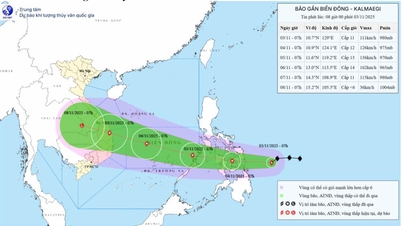
It is forecasted that around tonight to tomorrow morning, the tropical depression will likely strengthen into a storm and around November 5, the storm will enter the East Sea, becoming storm number 13.
On the afternoon of November 1, the National Center for Hydro-Meteorological Forecasting said that there is an active tropical depression in the eastern part of the Philippines. It is forecast that between tonight and the morning of November 2, the tropical depression will likely strengthen into a storm.
According to the hydrometeorological agency, around November 5, the storm will enter the East Sea and become storm number 13. It is forecasted that this will be a strong storm in the East Sea, the strongest in the Truong Sa special zone can reach over level 12.
 |
| Storm No. 13 may form in the coming days (Photo: Disaster monitoring system). |
The hydrometeorological agency said that around November 7, the storm will move to the mainland of our country, the focus area that needs to be noted and likely to be directly impacted is from Da Nang to Khanh Hoa.
The storm is forecast to cause strong winds and heavy rain in the provinces of the Central Central, South Central, and Central Highlands regions around the night of November 6-9.
The Hydrometeorological Agency noted that the storm has not yet formed and is still affected by many large-scale factors in the coming days as well as the impact of terrain when making landfall in the Philippines, so scenarios on the storm's intensity, direction of movement as well as areas directly affected by the storm still need to be monitored and updated with new observation and forecast data.
According to dantri.com.vn
Source: https://baovinhlong.com.vn/thoi-su/202511/bao-so-13-co-the-sap-hinh-thanh-kha-nang-anh-huong-den-dat-lien-nuoc-ta-1a30432/


![[Photo] Opening of the 14th Conference of the 13th Party Central Committee](https://vphoto.vietnam.vn/thumb/1200x675/vietnam/resource/IMAGE/2025/11/05/1762310995216_a5-bnd-5742-5255-jpg.webp)


![[Photo] Panorama of the Patriotic Emulation Congress of Nhan Dan Newspaper for the period 2025-2030](https://vphoto.vietnam.vn/thumb/1200x675/vietnam/resource/IMAGE/2025/11/04/1762252775462_ndo_br_dhthiduayeuncbaond-6125-jpg.webp)


Comment (0)