
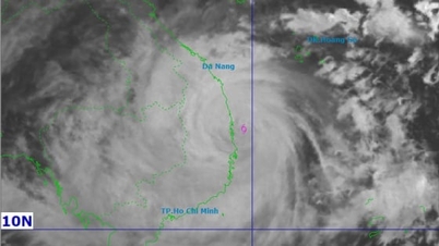
The strongest wind is level 15 (167-183km/h), gusting over level 17. It is forecasted that in the next 3 hours, the storm will move mainly to the West, at a speed of about 20-25km/h.
Forecast for the coming time:

Due to the impact of the storm, the sea area west of the Central East Sea has strong winds of level 8-12; the area near the storm's eye has strong winds of level 13-15, gusting over level 17, waves 6.0-8.0m high, the area near the storm's eye has waves 9.0-11.0m high; the sea is very rough.
The sea area from South Quang Tri to Khanh Hoa (including Ly Son special zone, Cu Lao Cham island) has winds gradually increasing to level 7-8, then increasing to level 9-12, waves 4.0-7.0m high; the area near the storm center has strong winds of level 13-15, gusting above level 17, waves 8.0-10.0m high; the sea is very rough.
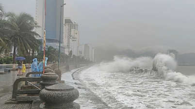
Coastal areas from South Quang Tri to Dak Lak have storm surges of 0.5-1.0m. The highest sea levels are in Thuan An (1.0m), Son Tra (1.2m), Hoi An (1.3m), Dung Quat (1.5m), Quy Nhon (1.2m), Tuy Hoa (1.1m).
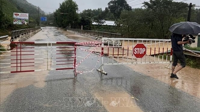
Warning from the afternoon of November 6, coastal areas from South Quang Tri - Dak Lak are on guard against rising sea levels accompanied by large waves causing flooding in low-lying areas, waves overflowing dikes, coastal roads, coastal erosion, slowing down flood drainage in the area. All ships, boats, and aquaculture areas in the above-mentioned dangerous areas are strongly affected by storms, whirlwinds, strong winds, large waves, and rising sea levels.
On land from the afternoon of November 6, on land from the South of Da Nang City to Dak Lak, the wind will gradually increase to level 6-7, then increase to level 8-9, the area near the storm center will be strong at level 10-13 (focusing on the East of Quang Ngai-Gia Lai provinces, North of Dak Lak), gusting at level 15-16; the area from South Quang Tri to the North of Da Nang City and North of Khanh Hoa province, the wind will increase to level 6-7, gusting at level 8-9. The strongest wind time will be from the evening to the night of November 6.
From the evening of November 6, in the West of the provinces from Quang Ngai to Gia Lai, the wind will gradually increase to level 6-7, near the storm's eye, it will increase to level 8-9, gusting to level 11.
From November 6-7, the area from Da Nang City to Dak Lak will have very heavy rain with common rainfall of 200-400mm/period, locally over 600mm/period; the area from South Quang Tri to Hue City, Khanh Hoa and Lam Dong will have heavy rain with common rainfall of 150-300mm/period, locally over 450mm/period. From November 8, heavy rain in the above areas will tend to decrease.
From November 7-8, the area from North Quang Tri to Thanh Hoa will have moderate to heavy rain with common rainfall of 50-150mm/period, locally very heavy rain over 200mm/period.
Warning of risk of heavy rain (>200mm/3h)
Due to the influence of the wide storm circulation, it is necessary to guard against the risk of thunderstorms, tornadoes and strong gusts of wind both before and during the storm's landfall.
Source: https://baophapluat.vn/bao-so-13-giat-tren-cap-17-tien-sat-quy-nhon.html


![[Photo] Closing of the 14th Conference of the 13th Party Central Committee](https://vphoto.vietnam.vn/thumb/1200x675/vietnam/resource/IMAGE/2025/11/06/1762404919012_a1-bnd-5975-5183-jpg.webp)


Comment (0)