

From November 1-4, the area from Ha Tinh to Da Nang city and the east of Quang Ngai province will have heavy to very heavy rain.
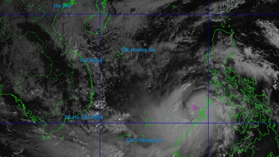
According to the initial assessment of the National Center for Hydro-Meteorological Forecasting on the possibility of storm No. 13 appearing in the East Sea, currently (afternoon of November 1) in the eastern region of the Philippines there is an active tropical depression, located at 1:00 p.m. at about 9.9 degrees North latitude -138.4 degrees East longitude.
Current forecast data shows: Tonight until tomorrow morning (November 2), the tropical depression is likely to strengthen into a storm. Around November 5 (Wednesday), the storm will enter the East Sea and become storm number 13. This is forecast to be a strong storm in the East Sea, strongest in the Truong Sa special zone, possibly above level 12.
Around November 7, the storm will move into the mainland of our country, the focus area that needs to be noted that is likely to be directly affected is from Da Nang City to Khanh Hoa . The storm can cause strong winds and heavy rain in the provinces of the Central Central, South Central, and Central Highlands regions from the night of November 6 to November 9.
The National Center for Hydro-Meteorological Forecasting noted that the storm has not yet formed and is still affected by many large-scale factors in the coming days as well as the impact of terrain when it makes landfall in the Philippines, so scenarios on the intensity, direction of movement as well as areas directly affected by storm No. 13 still need to be monitored and updated with new observation and forecast data.
From the night of October 31 until now (November 1), in the area from Ha Tinh to Da Nang City and the east of Quang Ngai province, there has been moderate rain, heavy rain, and locally very heavy rain and thunderstorms. According to the Center for Hydro-Meteorological Forecasting, the cause is the influence of cold air combined with the tropical convergence zone connecting with a low vortex in the central East Sea, in the upper atmosphere at an altitude of 1,500-5,000m, the humid East wind zone is active.
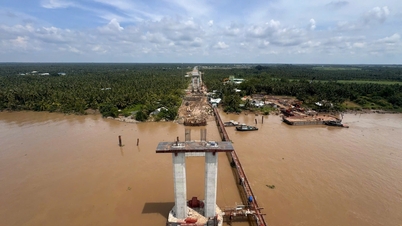
Regarding the flood situation, floods on rivers from Quang Tri to Quang Ngai tend to rise again. Currently, the water level on Gianh River (Quang Tri) is above level 1; on Bo River, Huong River (Hue City) is above level 2; on Vu Gia River, Thu Bon River (Da Nang City) is fluctuating at level 1-2; on Tra Khuc River (Quang Ngai) is at level 2.
Forecast of flood situation in the Central provinces
During the period from November 1-3, the cold air will continuously strengthen in combination with the tropical convergence zone with an axis passing through the South Central region (connected to the low pressure area in the South East Sea) with strong activity, the East wind zone in the atmospheric layers from 1,500-5,000 m will continue to be strong, so it is forecasted that from now (November 1) to November 4, the area from Ha Tinh to Da Nang City and the east of Quang Ngai province will have heavy to very heavy rain with rainfall in the area of Hue City, Da Nang City and the east of Quang Ngai province generally 300-600 mm, locally over 800 mm; in the area of Ha Tinh, Quang Tri generally 200-350 mm, locally over 500 mm; the south of Nghe An province and the west of Quang Ngai will have moderate to heavy rain with rainfall generally 70-150 mm, locally over 250 mm.
It is forecasted that rain in the Central region will tend to decrease during the period of November 5-6.
Due to the impact of heavy rain, from November 2-5, on rivers from Ha Tinh to Quang Ngai and Dak Lak, floods will appear, with the flood peaks on rivers likely to be as follows: Ha Tinh: Ngan Sau and Ngan Pho rivers will rise to levels BĐ2-BĐ3. Quang Tri: Gianh River will rise to levels BĐ2-BĐ3; Kien Giang and Thach Han rivers will rise to levels BĐ2-BĐ3 and above BĐ3. Hue City: Bo and Huong rivers will rise to levels BĐ3 and above BĐ3. Da Nang City: Vu Gia-Thu Bon rivers will rise to levels BĐ2-BĐ3 and above BĐ3. Quang Ngai: Tra Khuc and Ve rivers will rise to levels BĐ2-BĐ3 and above BĐ3, Se San rivers will rise to levels BĐ1-BĐ2. Small rivers, upstream of rivers in Gia Lai, Dak Lak and Khanh Hoa will rise to levels BĐ1-BĐ2 and above BĐ2.
There is a high risk of flash floods on small rivers and streams, landslides on steep slopes in mountainous areas of the provinces from Ha Tinh to Quang Gia Lai, especially in the provinces/cities of Ha Tinh, Quang Tri, Hue City, Da Nang City and Quang Ngai; of which Ha Tinh has 47 communes/wards; Quang Tri 30 communes/wards; Hue City 19 communes/wards; Da Nang City 62 communes/wards; Quang Ngai 52 communes/wards, Gia Lai 36 communes/wards with a very high risk of flash floods and landslides.
Thu Cuc
Source: https://baochinhphu.vn/bien-dong-sap-don-bao-so-13-du-bao-ngay-7-11-vao-dat-lien-cac-tinh-mien-trung-102251101184317506.htm


![[Photo] Opening of the 14th Conference of the 13th Party Central Committee](https://vphoto.vietnam.vn/thumb/1200x675/vietnam/resource/IMAGE/2025/11/05/1762310995216_a5-bnd-5742-5255-jpg.webp)


![[Photo] Panorama of the Patriotic Emulation Congress of Nhan Dan Newspaper for the period 2025-2030](https://vphoto.vietnam.vn/thumb/1200x675/vietnam/resource/IMAGE/2025/11/04/1762252775462_ndo_br_dhthiduayeuncbaond-6125-jpg.webp)


Comment (0)