
Early warning technology needs to be easily accessible to the community
This is one of the main messages presented at the Seminar "Solutions and technology for flash flood and landslide warning in the community" jointly organized by the Ministry of Agriculture and Environment , the Community Fund for Natural Disaster Prevention and the Agriculture & Environment Newspaper on the morning of April 25 in Hanoi.
According to Deputy Minister Le Cong Thanh, although there is early warning technology, it is necessary to connect it with the community in an effective, understandable and timely manner. Mr. Thanh proposed promoting the socialization of warning work, combining scientific data with local experience, building automatic warning stations, and perfecting the information sharing mechanism between levels.

In recent years, Vietnam has made great strides in research, application and technology transfer for forecasting and warning of flash floods and landslides - from automatic rain gauge sensor systems, remote sensing techniques, risk maps to artificial intelligence (AI) models and big data.
Technology is only part of the solution. The key is making the warning information, often delivered in technical jargon and with complex maps, understandable and actionable to people in remote areas.
Mr. Thanh assessed that in reality, in many mountainous areas, warnings are still unfamiliar. People only know about flash floods when the water has already flooded, when rocks and soil have collapsed on their houses. Not because they do not want to prevent them, but because they do not know what to do, are not trained, and do not have early enough and understandable warnings.
Dr. Cao Duc Phat, Chairman of the Community Fund for Natural Disaster Prevention, also shares the same view: “We need simple, effective, easy-to-implement warning solutions that are especially suitable for each local condition.”
Dr. Cao Duc Phat, Chairman of the Community Fund for Natural Disaster Prevention, said that the implementation of Decision 1262/QD-TTg on early warning of landslides and flash floods has created positive changes, contributing to strengthening monitoring and warning of natural disasters in mountainous and midland areas.
The Community Disaster Prevention Fund has been implementing many community-level disaster early warning models: from installing automatic rain gauge stations, building flash flood warning siren towers, to supporting the establishment and capacity building of disaster prevention teams in villages.
To date, there have been 16 flood warning towers and 85 shock teams deployed in high-risk areas. However, Mr. Phat believes that it is necessary to expand the scale and increase synchronization: connecting data between systems; integrating warnings with risk maps; bringing information directly to people through various forms such as loudspeakers, SMS messages, phone applications, or simply bulletin boards at cultural houses.
Many gaps to be filled
Mr. Nguyen Xuan Tung, Deputy Head of the Department of Natural Disaster Response and Overcoming, Department of Dyke Management and Natural Disaster Prevention, commented: Forecasting and warning of flash floods and landslides in Vietnam has made remarkable progress in recent years. The National Center for Hydro-Meteorological Forecasting has now established a system for warning of heavy rain and natural disasters down to the commune level, through an online platform at luquetsatlo.nchmf.gov.vn.
In the field, localities have installed about 1,500 automatic rain gauges, helping to collect data quickly to serve warnings and timely evacuations. At the same time, many provinces and cities have proactively developed plans to prevent and combat natural disasters, organized the evacuation of residents from risk areas, and invested in warning works and response to flash floods and landslides.
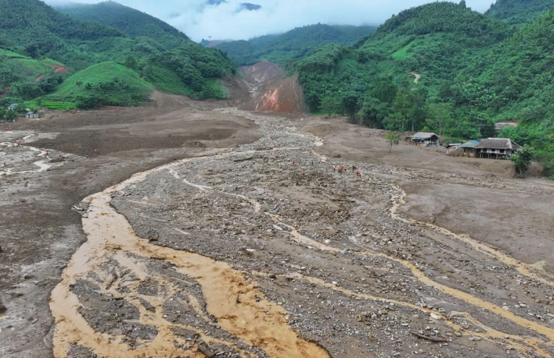
In the past 15 years, flash floods and landslides have tended to increase rapidly due to prolonged heavy rain and extreme heavy rain in a short period of time.
However, according to Mr. Tung, reality shows that there are still many gaps that need to be overcome. The rugged terrain, short-term heavy rains and complex geology in mountainous areas make it challenging to accurately determine the location and time of natural disasters. Forecasts and warnings are still limited in detail and reliability; the monitoring system is not yet fully covered, many devices are outdated, while risk maps are still mainly large-scale, not specific to the village level, making it difficult for on-site prevention and response.
Not only are there difficulties in technical forecasting, community response work is also limited. People's awareness and emergency response skills, especially in remote areas, are still weak. Local shock forces lack human resources, equipment and have not been properly trained. Climate change is changing traditional flood and rainfall patterns, making current forecasting models less accurate. At the same time, unsustainable socio-economic development activities such as deforestation, mining, illegal construction on hillsides, etc., further increase the risk of natural disasters. Meanwhile, the work of relocating residents in dangerous areas faces many obstacles in terms of land funds, funding and ensuring long-term livelihoods for people.
Faced with the above challenges, the Department's representative proposed groups of synchronous solutions. In terms of policies and institutions, it is necessary to continue to improve the legal corridor, increase investment in warning systems and disaster prevention and control works; tighten management of construction planning, and link population relocation with sustainable livelihood development. In terms of technology, it is necessary to promote short-term heavy rain forecasting capacity, build detailed risk maps down to the village level, deploy rain gauge sensors and warning devices using digital technology and artificial intelligence (AI).
On the community side, communication programs need to be designed to be simple and easy to understand, combined with training in coping skills for people - especially vulnerable groups. At the same time, it is necessary to improve capacity and invest in equipment for on-site shock troops. Finally, Mr. Tung emphasized the role of international cooperation and the private sector in providing appropriate technological solutions, while effectively mobilizing financial resources such as the state budget, disaster prevention funds and national target programs.
To effectively respond to the risk of flash floods and landslides, Mr. Mai Van Khiem, Director of the National Center for Hydro-Meteorological Forecasting, informed that a real-time flash flood and landslide warning system has been developed and put into operation in Vietnam. "The system is updated hourly, detailed down to the commune level and can forecast the risk of flash floods and landslides in the next 6 hours," said Mr. Khiem.
Source: https://cand.com.vn/Xa-hoi/canh-bao-som-hanh-dong-som-la-chia-khoa-giam-thieu-thiet-hai-do-lu-quet-i766397/


Comment (0)