
Many experts believe that identifying each plot of land not only helps improve the efficiency of land management but also makes land procedures simpler - Photo: QUANG DINH
The Ministry of Agriculture and Environment is guiding localities to implement land database adjustments and build identification codes for each land plot.
Improve land management efficiency
According to Mr. Mai Van Phan - Deputy Director of the Department of Land Management, Ministry of Agriculture and Environment, this is a key step to realize the policy of administrative reform, digitizing land management according to the two-level local government model. Each land plot will be assigned a unique 12-character identification code, encoded according to location, longitude, and latitude.
Regarding the land identification code assignment process, Mr. Phan said it includes four steps: determining the characteristic point, converting the location from the Vietnamese coordinate system (VN2000) to the international coordinate system (WGS84), encoding the land plot location, and updating it to the land database.
For areas without a cadastral database, the management agency will collect land use certificates and citizen identification cards of owners to create initial data for each plot of land. After checking and reconciling, the People's Committee at the commune level will update the general land information system.
According to Mr. Phan, the initial identification code only stores information about the coordinates and location of the land plot, while information about the size, area, and value of the land plot will be integrated into the land database. The land plot identification code is similar to the code in the citizen identification card, each land plot has only one code. Through the identification code, people can access the land data system to know where the land plot is located.
"We cannot put all land plot information into the land identification code, because there is land information that can be shared, and there is information that cannot be shared," he added.
The issuance of land identification codes will eliminate the situation of a piece of land having multiple red books, reduce fraud, limit disputes, create a joint venture platform with the system of place names, digital land administration and other national databases. At the same time, it will help the real estate market have a more solid legal basis and data compared to the current manual and paper management method.
According to Associate Professor Dr. Nguyen Quang Tuyen - Vice President of the Council of Hanoi Law University, identifying each plot of land contributes to improving the land transparency index, which we have discussed and talked about a lot. Moreover, identifying each plot of land with a specific code is to have clean information, accurate, clean, and alive information.
"Thereby, state management agencies can have reference information to serve the development of standard policies and laws. At the same time, it will improve the efficiency of land management, gradually purify the market and clarify assets. As it is now, it is very difficult to determine how many properties a person has," said Mr. Tuyen.
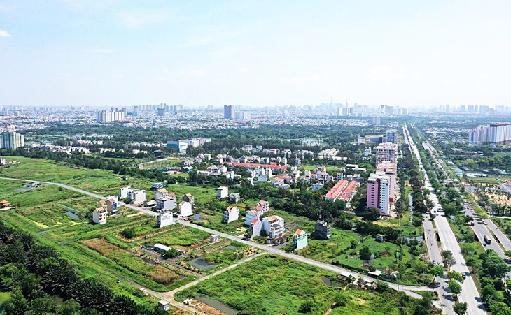
Issuing "identification" for each plot of land is the basis for building transparent and synchronous land data - Photo: QUANG DINH
Land procedures will be simpler
Although he supports the integration of land data with the information system and national population database so that people can easily access data on land plots and management agencies can control the land market, Mr. Tuyen also said that this has obstacles when a part of society, for some reason, group interests, do not want to integrate information because it reveals the assets they are holding.
Speaking to Tuoi Tre, Mr. Nguyen Van Dinh, Vice President of the Vietnam Real Estate Association, said that land identification associated with the process of completing land data, connecting with population data on VNeID will facilitate the settlement of procedures on the digital platform in the future. Land procedures will be processed very quickly on the digital platform without having to present too many documents.
Each plot of land is identified, encoded, and updated on the land data system, connected with the population data system on VNeID, which will reduce many administrative procedures for people and businesses. When the data is available on the system managed by the State, people and businesses who want to do land procedures will not have to notarize many documents as they do now.
"Land transfer transactions are also processed with encryption and data transfer, through which management agencies can also monitor movements, identify market activities, and manage the operation of real estate in the market," said Mr. Dinh.
According to Mr. Dinh, land identification aims at two goals: first, it helps people easily handle related procedures in the simplest and fastest way possible. Second, it helps state management agencies control the land market.
In the long term, Mr. Dinh recommends that land identification should aim to update information such as size, area, and value of each plot of land in the land identification code. This will help people have full data in hand when doing procedures without having to carry cumbersome documents and records like at present.
Integrate with population data but keep data secure
According to the report on the summary of the implementation of the 2014 Land Law, up to now only 77% of the natural land area has been measured, while 23% of the natural land area has not been mapped.
Thus, it is still necessary to invest human resources and time to continue to complete the measurement information and clearly define the boundaries, landmarks, and area of each plot of land to have input material for identification. Without information, it is very difficult to identify.
Regarding the next issue that needs to be raised after integrating land data with population data, according to Associate Professor Dr. Nguyen Quang Tuyen, is data security. In addition, it is necessary to review and amend and supplement relevant legal regulations because there is information that is confidential and cannot be made public.
"There is information that is only for state management purposes. Therefore, it is necessary to distinguish what type of information is made public for all citizens and what type of information can only be used by management agencies," said Mr. Tuyen.
Mr. David Jackson (General Director of Avison Young Vietnam):
The basis for building transparent and synchronous data

Experience from the UK's Her Majesty's Land Registry (HMLR) and the Singapore Land Authority (SLA) shows that land parcel identification systems play a crucial role in effective land management.
HMLR provides reliable information on land ownership through State-run processes and records.
SLA issues unique parcel identifiers that are integrated into the cadastral survey to ensure accurate spatial and legal referencing.
When each plot of land is assigned a unique identification code, the problem of duplicated sheet numbers and plot numbers will be resolved, and a transparent, synchronized database will be formed nationwide. The real estate market will therefore be more transparent, efficient and reliable with "correct - sufficient - clean - alive" data when it is accurate, complete, in the right format, non-duplicated and continuously updated.
The implementation process needs a clear roadmap, the first phase must apply both the old sheet and plot numbers with the new identification codes in parallel before completely converting. Because land is a fixed asset, the coding by geographic location (coordinates) must be absolutely accurate and issued only once, and at the same time separate from the administrative unit system to avoid disruption when the boundaries change. This is a high technical requirement, requiring careful and synchronous implementation.
Mr. Vo Hong Thang (Director of consulting and project development services of DKRA Group):
Dual benefits of land parcel identification

Successful land parcel identification will bring many great advantages. First of all, it will create a complete national database.
Thanks to that, the State will have enough tools to monitor fluctuations in real estate market prices in each area, and to develop more effective management policies and solutions.
This will also help make the market more transparent, reducing the risk of a real estate crash or bubble.
A complete and transparent database will also effectively support the implementation of tax obligations and avoid tax losses.
This is also a very reasonable preparation step for moving towards property taxation in the future. In particular, this data synchronization also helps solve a current painful problem: land disputes.
However, it should first be piloted in some key localities such as Ho Chi Minh City and Hanoi, and centrally-run cities. After the system has been refined and stabilized, it will be replicated nationwide to have a national data map and identify the entire country.
Mr. Le Quoc Kien (resident of Ho Chi Minh City):
People will know the transaction price history clearly.

Identifying each plot of land will accurately update the latest owner information after a sale or division transaction and provide more complete information such as linking the name to the personal identification code, and if possible, there should be a history of transaction prices from the notarization system, information already available on the cadastral map.
On the current cadastral map, each plot of land has an owner's name, but the latest owner's information is not accurately updated after the sale or division transaction.
After identifying each plot of land more accurately and completely, combined with publicizing the cadastral map (currently not public, only responsible officials can see it), people will have many benefits when knowing exactly who owns that plot of land.
People will know exactly who the land owner is, which will limit the risk of being scammed and defrauded. Moreover, people will also know the history of previous purchase and sale prices if the transaction prices are synchronized from the notary system.
Source: https://tuoitre.vn/cap-can-cuoc-cho-tung-thua-dat-chia-khoa-minh-bach-thi-truong-20250923081204765.htm








![[Video] Hue Monuments reopen to welcome visitors](https://vphoto.vietnam.vn/thumb/402x226/vietnam/resource/IMAGE/2025/11/05/1762301089171_dung01-05-43-09still013-jpg.webp)





Comment (0)