

Reporter : Sir, could you please give us the latest update on storm Kalmaegi (storm number 13) and the dangerous impacts that people need to pay special attention to?
Mr. Mai Van Khiem : As of 5:00 p.m. this afternoon, November 5, the circulation of storm No. 13 is active in the eastern part of the East Sea, about 320km from Song Tu Tay Island (Truong Sa archipelago), and more than 900km from our mainland. The storm has been moving at a steady speed of about 20km/h-25km/h since this morning, and is forecast to maintain this speed tonight as well as tomorrow.
Currently, the storm maintains a strong intensity of level 14, gusting over level 17 and is likely to continue to strengthen in the next 12-18 hours, reaching level 14-15. This is a very strong storm, assessed as especially dangerous, when approaching the mainland it may still maintain strong winds, greatly affecting the central region from the evening and night of November 6.
Reporter : So what specific dangerous impacts need to be warned to the community, sir?
Mr. Mai Van Khiem : The meteorological agency has continuously issued warnings about the major risks caused by storm No. 13, including strong winds, high waves and heavy rain over a wide area. These factors can lead to floods, flash floods and landslides in many central regions.
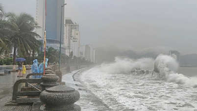
First of all, in the East Sea and coastal waters, strong winds can reach level 13-14, gusting to level 17; waves around the storm center are from 8m-10m high. With such wind and wave conditions, this is an extremely dangerous level for all types of vessels, including large vessels, if they are still operating in the storm's affected area.
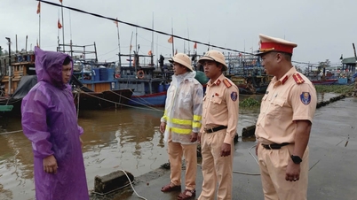
In coastal areas, winds can be as strong as level 12, waves 4m-6m high. In particular, currently in the high tide period, combined with storm surges, the total water level can increase by 0.9m-1.2m. With these combined impacts, all activities of boats and aquaculture cages along the coastal area from southern Quang Tri to Dak Lak are very dangerous, and urgent measures are needed to ensure safety.
Localities with many boats and aquaculture areas, especially in Gia Lai , Dak Lak and neighboring areas, must be extremely vigilant and proactive in response plans.
Reporter : On land, how is storm number 13 forecast to affect, sir?
Mr. Mai Van Khiem : According to our assessment, the circulation of storm No. 13 will cause strong winds over a wide area, especially along the area from Quang Tri to Khanh Hoa . In particular, the area with the strongest winds is determined to be the Dak Lak, Gia Lai and Quang Ngai areas, where the wind speed can reach level 10-12, gusting to level 15, or even higher.
The storm moves quickly and is very strong, so it not only causes strong winds in coastal areas but also affects deep inland. According to the current forecast direction, the storm will enter the area between Gia Lai and Quang Ngai. On this path, the Central Highlands provinces are expected to be affected by very strong winds, especially in areas with high terrain such as An Khe Pass. According to our experience in monitoring previous storms, in this area the wind can be as strong as level 9-10, gusting over level 12. This is an extremely dangerous wind level, especially for high-rise structures such as wind power plants, which require absolute safety measures.
Reporter : Besides strong winds, what are the notable points about the rainfall caused by storm No. 13, sir?
Mr. Mai Van Khiem : Although the cold air has weakened and the factors causing extreme rain such as high-altitude easterly wind disturbances are no longer as strong as in previous days, the circulation of storm No. 13 still has the potential to cause very heavy rain in the central and south-central regions.
Rainfall is forecast to be between 200mm and 300mm, with some places reaching 500mm and 600mm, concentrated between the afternoon of November 6 and the morning of November 7. Provinces that need special attention include Dak Lak, Gia Lai, Quang Ngai, Da Nang, Hue city and southern Quang Tri.
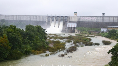
Heavy rainfall in a short period of time can pose a high risk to reservoirs, especially medium and small reservoirs in the South Central and Central Highlands regions. Localities need to proactively develop plans for dam operation and safety inspection, and respond promptly to minimize potential damage.
Reporter : Can you tell us more specifically about the risk of floods caused by storm number 13?
Mr. Mai Van Khiem : With heavy rainfall in a short period of time, we especially warn of the risk of a new flood on the river systems in the provinces of Dak Lak, Gia Lai, Quang Ngai, Da Nang and Hue city. In the context of the water level on the rivers still being high, the possibility of floods from alert level II to alert level III is very high, some rivers may even exceed alert level III.
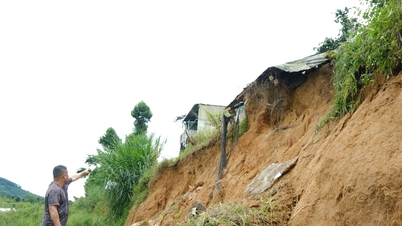
One point worth noting is that the risk of flash floods and landslides is particularly high in the entire mountainous area of the western part of the central provinces and the Central Highlands. This is an issue we have continuously warned about in the past days and will continue to monitor and update in the coming days. Localities need to pay special attention, especially in areas with steep terrain, saturated soil or construction works along the mountain slopes.
Reporter: Besides rain and floods, are there any other weather phenomena that people need to pay attention to during this storm, sir?
Mr. Mai Van Khiem: In addition to rain and floods, we would like to emphasize that thunderstorms and tornadoes may appear from tonight, although the eye of the storm is still quite far away. Coastal areas in the central region and from tomorrow morning, coastal areas and mainland provinces in the central region need to be extremely vigilant. The circulation of storm No. 13 can cause very strong winds, thunderstorms and tornadoes before the storm makes landfall.
The storm’s dense, swirling cloud system is capable of creating dangerous eddies, especially in coastal waters where winds converge strongly. Residents, fishermen and coastal structures must absolutely not be subjective, closely monitor warnings to proactively prevent.
Reporter: Thank you!
Source: https://baolamdong.vn/chuyen-gia-canh-bao-bao-so-13-co-the-gay-gio-giat-cap-17-mua-toi-600mm-va-lu-quet-nghiem-trong-400581.html


![[Photo] Closing of the 14th Conference of the 13th Party Central Committee](https://vphoto.vietnam.vn/thumb/1200x675/vietnam/resource/IMAGE/2025/11/06/1762404919012_a1-bnd-5975-5183-jpg.webp)

![Building a 'fortress' against natural disasters: [Part 2] Changing state from passive to active](https://vphoto.vietnam.vn/thumb/402x226/vietnam/resource/IMAGE/2025/11/06/1762423529917_0242-2223-160125_902.jpeg)


Comment (0)