
The huge amount of water flowing from upstream, combined with the regulation of hydroelectric reservoirs, has pushed the water level on the Vu Gia - Thu Bon rivers to the highest alarm level, causing the risk of widespread flooding. The entire political system and the people of the city are having to "stretch themselves" at the highest level to respond to this complex natural disaster.
According to a quick report from the Department of Water Resources and Irrigation Management (Department of Agriculture and Environment of Da Nang City), as of 5:00 p.m. on October 27, the natural disaster situation is at an alarming level. From 7:00 p.m. on October 26 to 2:00 p.m. on October 27, heavy rain occurred in Da Nang City, very heavy rain in many places. Rainfall at specialized measuring stations in mountainous areas recorded record numbers in the past 24 hours (as of 1:45 p.m.): Ba Na 488.8mm; Nong Son: 426.2mm; Hiep Duc: 407.8mm. This huge amount of water caused the water level on rivers and streams to rise rapidly and flow rapidly. The water level on Vu Gia and Thu Bon rivers was above Alert Level III (BĐ3).
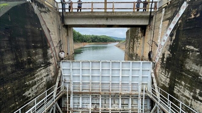
Large hydropower reservoirs such as Song Tranh 2, A Vuong, Song Bung 4, Song Bung 2, Dak Mi 4 are operating to cut and reduce floods for downstream areas. However, the pressure of flood discharge combined with the water flowing from the source still makes the flood situation in the downstream tense. Warning of the risk of widespread deep flooding in low-lying areas along the river, flooding in urban areas, with common depths from 0.2m to 2m.
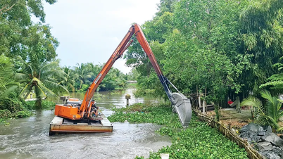
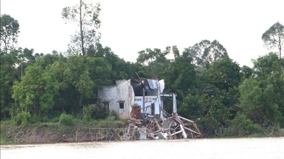
Heavy rains for many days have caused serious landslides in mountainous communes in the west of the city and neighboring areas. Soil moisture models show that some areas in Da Nang city are nearly saturated (over 95%), pushing the risk of flash floods and landslides to a very high level. Mountainous communes have recorded heavy damage, and traffic is seriously disrupted.
In Phuoc Chanh commune, the district roads in the area suffered particularly serious landslides, with the volume of landslides at 22 points estimated at over 10,000m³, burying many sections of road, causing traffic disruption between villages and Phuoc Thanh commune.
Many roads in Tra Linh, Tra Doc, and Phuoc Thanh communes were also eroded by thousands of cubic meters of rock and soil, completely paralyzing traffic. The landslides and isolation in mountainous communes such as Hiep Duc, Phuoc Hiep, and Kham Duc, where there was also a lot of rain, were recorded as particularly serious, causing traffic congestion between communes and isolating many residential areas on steep slopes. Many national highways and key traffic routes such as 14B, 14E, etc. were also eroded at many points, causing traffic disruption.
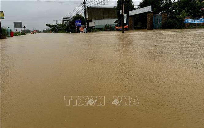
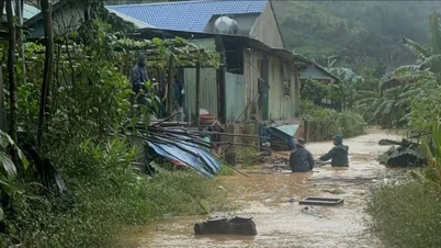
As floodwaters from upstream exceeded Alert Level 3 (BĐ3), low-lying areas and "flood centers" of the Vu Gia - Thu Bon basin began to suffer from deep flooding. Communes in Dai Loc district, former Quang Nam province, located at the confluence of the Vu Gia and Thu Bon rivers, became some of the most deeply flooded areas.
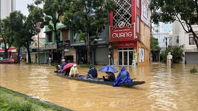
The surging river water has submerged many fields and villages along the river. The depth of flooding in low-lying areas has exceeded 1.0m, cutting off many important inter-district roads, forcing hundreds of households to evacuate urgently. The water level is expected to continue to rise overnight, making rescue and evacuation work even more urgent and difficult.
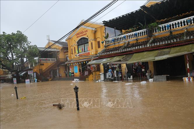
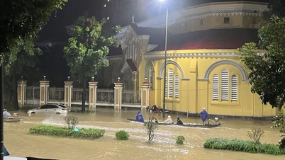
In Hoi An, downstream of the Thu Bon River, heavy floods from upstream have caused severe flooding in the Old Quarter and riverside communes. Roads along the Hoai River have begun to be submerged, affecting tourism activities and people's lives.
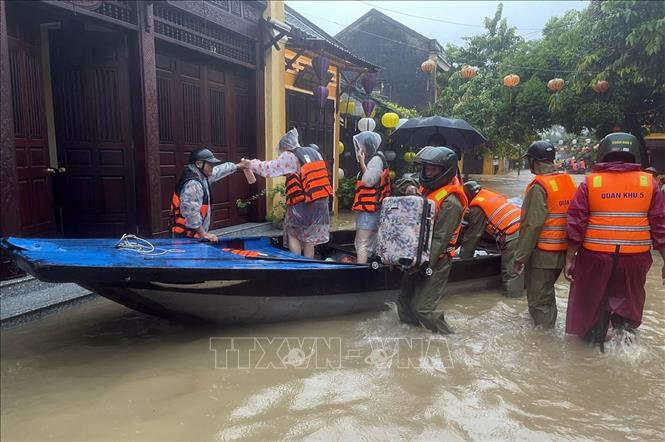
Faced with this situation, Chairman of the People's Committee of Hoi An Ward (Central Ward of the Old Quarter) Nguyen Tan Cuong mobilized all militia, police and youth volunteers to propagate and support people to urgently move their assets and livestock to higher ground; at the same time, strictly prohibiting people and tourists from traveling by boat in flooded areas without permission from the authorities to ensure safety. Checkpoints on deeply flooded roads have been set up to prevent curious people from approaching.
Vice Chairman of the People's Committee of Da Nang City Tran Nam Hung said that the natural disaster situation is getting worse, the entire political system of Da Nang City has been mobilized at the highest level, in which the armed forces play the role of spearhead. The Da Nang City Civil Defense Command has held an online meeting, established a Forward Command Committee to directly direct the response and overcoming of consequences. Urgent directives have been issued, requiring localities to strictly implement the "4 on-site" motto (on-site command, on-site forces, on-site supplies, on-site logistics).
The city also requires the units managing irrigation and hydropower reservoirs in the area and river basins to strictly operate according to the approved inter-reservoir process, to cut and reduce floods for the downstream area to the maximum while still ensuring the safety of the works. Departments, branches and localities are seriously implementing the instructions, regularly closely monitoring forecasts and warnings of natural disasters and are ready to deploy two plans to prevent and combat natural disasters to minimize damage to people and property.
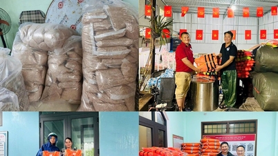
Faced with the risk of flash floods and landslides threatening lives, the city and local authorities have launched the largest emergency evacuation in recent years. As of 5:00 p.m. on October 27, 2025, a total of 785 households/2,896 people have been evacuated to safety. People were mainly evacuated to solid locations such as village cultural houses, schools (such as Tra Leng 1 Secondary School, Nguyen Ba Ngoc Primary School) or interspersed to households in high locations, avoiding the risk of being buried by rocks and soil. Communes with a large number of evacuations include Tra Doc (141 households/620 people), Tra Linh (49 households/206 people) and Tra My (59 households/214 people), mainly households located at the foot of hills at high risk of landslides and households along rivers and streams...
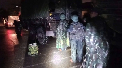
The Police, Military (Military Region 5, Military Command, Border Guard) and Militia forces have been highly concentrated, becoming the frontline forces in all rescue and relief activities. Thousands of officers and soldiers of the forces and local authorities have been on duty day and night, using specialized vehicles and motorboats to evacuate people in high-risk areas to safe shelters.
In landslide areas in mountainous areas, police and military forces immediately approached, using machinery and manual labor to clear thousands of cubic meters of earth and rock, quickly opening temporary routes to reach isolated residential areas, and transferring food, drinking water and essential supplies.
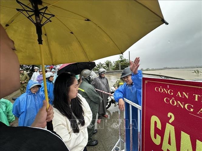
In low-lying areas, the police force has set up 24/7 checkpoints, determined not to allow people to pass through deeply flooded areas, areas with fast-flowing water, or eroded bridges and culverts, to prevent human casualties. Military Region 5 has also established a Forward Command Post in Tra My commune to respond to floods and landslides in the southern part of the city.
Up to now, although the flood situation is still complicated and may last longer, thanks to the proactiveness and coordinated efforts of the entire political system, the initial response work has helped ensure the safety of people's lives and minimize property damage from the wrath of nature. Da Nang and neighboring provinces are continuing to fight, ready to overcome the consequences when the flood recedes.
Source: https://baotintuc.vn/dia-phuong/da-nang-gong-minh-truoc-mua-lu-huy-dong-luc-luong-tuyen-dau-ung-pho-20251027221359260.htm


![[Photo] The 5th Patriotic Emulation Congress of the Central Inspection Commission](https://vphoto.vietnam.vn/thumb/1200x675/vietnam/resource/IMAGE/2025/10/27/1761566862838_ndo_br_1-1858-jpg.webp)


![[Photo] Prime Minister attends the 28th ASEAN-China Summit](https://vphoto.vietnam.vn/thumb/402x226/vietnam/resource/IMAGE/2025/10/28/1761624895025_image-2.jpeg)


![[Photo] Party Committees of Central Party agencies summarize the implementation of Resolution No. 18-NQ/TW and the direction of the Party Congress](https://vphoto.vietnam.vn/thumb/1200x675/vietnam/resource/IMAGE/2025/10/27/1761545645968_ndo_br_1-jpg.webp)
![[Photo] National Assembly Chairman Tran Thanh Man receives Chairman of the House of Representatives of Uzbekistan Nuriddin Ismoilov](https://vphoto.vietnam.vn/thumb/1200x675/vietnam/resource/IMAGE/2025/10/27/1761542647910_bnd-2610-jpg.webp)


Comment (0)