Latest cold air news: The National Center for Hydro-Meteorological Forecasting said that currently in the North, a cold air mass is moving down to the South of our country.
Latest cold air news
Currently (January 8), the cold air mass is reported to be moving south.
Latest cold air news: Cold air is on its way down, tomorrow night, January 9, the North will be very cold.
Forecast of cold air developments in the next hours:
Around January 9, this intensified cold air mass will affect the Northeast region, then affect the North Central region and some places in the Northwest and Central Central regions. From the night of January 10, the cold air mass will continue to intensify and affect other places in the Northwest and Central Central regions, some places in the South Central region. Northeast winds inland will gradually strengthen to level 2-3, coastal areas level 3-4.
According to weather forecasts, the dry spell in the North will end today. Cold air will continue to strengthen over the next three days.
Today the cold air is weak and moving eastward. Then the cold air will strengthen again on January 9 and 10.
Although the cold air is continuously strengthened, the temperature does not decrease much, severe cold only occurs in the northern mountainous region. Other places have moderate cold.
In the North, North Central and Central Central regions, the weather continues to be cold, in the mountainous and midland areas of the North, there are places with severe cold. The lowest temperature in this cold air mass in the North and North Central regions is generally 10-13 degrees, in the mountainous areas of the North, 6-9 degrees, in the high mountains, some places below 5 degrees; in the area from Quang Binh to Thua Thien Hue, it is generally 15-18 degrees. Hanoi area: Cold. The lowest temperature in this cold air mass is generally 10-13 degrees.
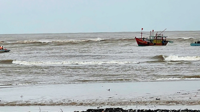
From noon and afternoon of January 9, the Northeast wind in the North East Sea gradually increased to level 7, gusting to level 8-9, rough seas, and waves 3.0-5.0m high. From the night of January 9, the sea in the West of the South East Sea (including the sea west of Truong Sa archipelago) and the sea from Khanh Hoa to Binh Thuan gradually increased to level 7, gusting to level 8-9, rough seas, and waves 2.0-4.5m high.
From the afternoon to the night of January 9, in the Gulf of Tonkin, the Northeast wind gradually increases to level 6, sometimes level 7, gusting to level 8-9, rough seas, waves from 1.5-3.5m high; in the sea area from Quang Tri to Phu Yen and the central East Sea, the Northeast wind gradually increases to level 6-7, gusting to level 7-8, rough seas, waves from 2.0-4.5m high.
| Forecast time | Area of influence | Lowest temperature ( o C) | Average temperature ( o C) |
| Day and night 09/01 | Northern Vietnam and Thanh Hoa | 13-15, Northern mountainous areas 11-13, high mountainous areas in some places under 10 | 16-18, in the Northern mountainous region, some places are under 15 |
| North Central Coast | 15-17 | 19-21 |
Due to the influence of cold air strengthening from the afternoon of January 9, the area from Ha Tinh to Binh Dinh will have rain, showers and scattered thunderstorms, locally heavy rain. During thunderstorms, there is a possibility of tornadoes, lightning and strong gusts of wind.
Thunderstorms accompanied by tornadoes, lightning and strong gusts of wind can affect agricultural production, cause trees to fall, damage houses, traffic works and infrastructure.
Localized heavy rains may cause flooding in low-lying areas; flash floods in small rivers and streams; landslides on steep slopes. Strong winds and large waves at sea may affect boating and other activities.
The North welcomes cold air, severe cold weather, localities are requested to proactively respond
According to the bulletin of the National Center for Hydro-Meteorological Forecasting, due to the influence of the strengthening cold air, from January 9, 2025, the weather in the North, North Central and Central regions will continue to be cold; the mountainous and midland areas of the North will have some places with severe cold; the lowest temperature in the North and North Central regions is generally from 10-13 degrees, the mountainous areas of the North will be 6-9 degrees, the high mountainous areas will be below 5 degrees; in the Gulf of Tonkin, the Central and Southern East Sea, the sea area from Quang Tri to Khanh Hoa will have strong northeast winds up to level 6, sometimes level 7, gusting to level 8-9, rough seas, waves from 3.0-6.0m high.
To proactively respond to the increasing cold air, cold and strong winds at sea, the Ministry of Agriculture and Rural Development recommends that provinces and cities in the Northern and North Central regions closely monitor warning bulletins and forecasts on the development of the increasing cold air and cold and promptly inform local authorities and people to proactively prevent it.
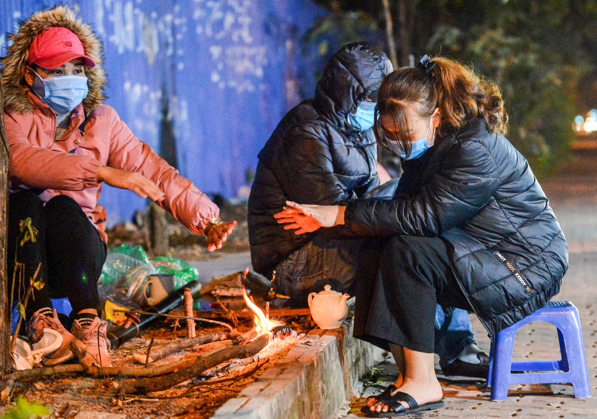
Review cold response plans; provide guidance on ensuring people's health, and do not use coal stoves to heat closed rooms to avoid human casualties.
Propagate and guide livestock farming households to strengthen barns, cover and keep warm, store food; prevent and control epidemics for livestock and poultry; guide measures to ensure safety for rice, vegetable and other crop production.
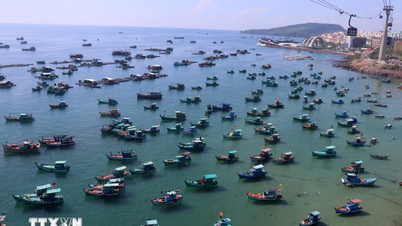
For strong winds at sea (coastal provinces and cities from Quang Ninh to Kien Giang, closely monitor warning bulletins, forecasts and developments of strong winds at sea; notify captains and owners of vehicles and vessels operating at sea to proactively prevent and have appropriate production plans, ensuring safety of people and property; maintain communication to promptly handle bad situations that may occur.
 ") // // .removeAttr("style"); el.find(".first").show(); el.find("a.second").html(""); el.find("a.second").removeAttr("data-out"); $('.comment-account').html(`
 ") // // .removeAttr("style"); el.find(".first").show(); el.find("a.second").html(""); el.find("a.second").attr("data-out", "0"); $('.comment-account').html(` ") // .removeAttr("style"); //el.find("a.second").html(""); }); }; fnPopupBindAction(); //login Facebook var otherLogin = { init: function() { var me = this; //gapi.load('auth2', function () { // gapi.auth2.init({ // client_id: '678720187862-08lendtdt5h3nr4j2he534p15b13aieg.apps.googleusercontent.com', // scope: 'email profile', // fetch_basic_profile: true // }); //}); $("#cmt-account-social button[data-type]").on('click', function() { me[$(this).attr("data-type")](function(response) { $("#cmt-account-header .tabs .close, #cmt-account .tabs .close") .click(); }); }); try { fbClient.appId = '1304555827613749'; //'211029740744825'; fbClient.version = "v14.0"; fbClient.init(); setTimeout(FB.AppEvents.logPageView, 5000); } catch (e) { // ignore } }, loginFacebook: function(cb) { var me = this; function reloginFacebook(callback) { FB.api('/me', { fields: 'id, name, email' }, function(profile) { //console.debug(profile); if (typeof callback === "function") callback(profile); }); }; FB.login(function(response) { if (response.authResponse) { reloginFacebook(function(info) { console.log(info); info.social = "facebook"; info.accessToken = response.authResponse.accessToken; var user = { email: info.email, name: info.name, } let now = new Date(); lgSetCookie('my_dv',JSON.stringify(user), new Date(now.getTime() + (30 * 12 * 60000))); authLogin(user.name, true); }); } else { $("#cmt_alert").html( "You have denied permission to access your Facebook account"); } }, { scope: 'public_profile,email' }); }, loginGoogle: function(callback) { var me = this; function callSocialApi(data, cb) { data.social = "google"; var user = { email: data.email, name: data.name, } let now = new Date(); lgSetCookie('my_dv',JSON.stringify(user), new Date(now.getTime() + (30 * 12 * 60000))); authLogin(user.name, true); } // API call for Google login if (gapi.auth2.getAuthInstance().isSignedIn.get()) { //console.debug('[VCC] GAPI Process'); var profile = gapi.auth2.getAuthInstance().currentUser.get().getBasicProfile(); //var id_token = gapi.auth2.getAuthInstance().currentUser.get().getAuthResponse().id_token; var access_token = gapi.auth2.getAuthInstance().currentUser.get().getAuthResponse() .access_token; var params = { id: profile.getId(), name: profile.getName(), email: profile.getEmail(), accessToken: access_token } //console.log('params: ', params); callSocialApi(params, callback); } else { //console.debug('[VCC] GAPI Login'); gapi.auth2.getAuthInstance().signIn().then( function(success) { var profile = gapi.auth2.getAuthInstance().currentUser.get() .getBasicProfile(); //var id_token = gapi.auth2.getAuthInstance().currentUser.get().getAuthResponse().id_token; var access_token = gapi.auth2.getAuthInstance().currentUser.get() .getAuthResponse().access_token; var params = { id: profile.getId(), name: profile.getName(), email: profile.getEmail(), accessToken: access_token } //console.log('params: ', params); callSocialApi(params, callback); }, function(error) { $("#cmt_alert").html( "You have refused to grant Dan Viet Newspaper permission to access your Google account" ); } ); } } } otherLogin.init(); });
Source: https://danviet.vn/tin-khong-khi-lanh-moi-nhat-dang-tren-duong-xuong-mien-bac-ret-dam-ha-noi-thap-nhat-10-do-20250108111514901.htm

![[Photo] Ho Chi Minh City Youth Take Action for a Cleaner Environment](https://vphoto.vietnam.vn/thumb/1200x675/vietnam/resource/IMAGE/2025/11/04/1762233574890_550816358-1108586934787014-6430522970717297480-n-1-jpg.webp)
![[Photo] Ca Mau "struggling" to cope with the highest tide of the year, forecast to exceed alert level 3](https://vphoto.vietnam.vn/thumb/1200x675/vietnam/resource/IMAGE/2025/11/04/1762235371445_ndo_br_trieu-cuong-2-6486-jpg.webp)
![[Photo] The road connecting Dong Nai with Ho Chi Minh City is still unfinished after 5 years of construction.](https://vphoto.vietnam.vn/thumb/1200x675/vietnam/resource/IMAGE/2025/11/04/1762241675985_ndo_br_dji-20251104104418-0635-d-resize-1295-jpg.webp)

![[Photo] Panorama of the Patriotic Emulation Congress of Nhan Dan Newspaper for the period 2025-2030](https://vphoto.vietnam.vn/thumb/1200x675/vietnam/resource/IMAGE/2025/11/04/1762252775462_ndo_br_dhthiduayeuncbaond-6125-jpg.webp)