
Specifically, due to the increased activity of cold air, the tropical convergence zone with its axis maintained through the Central Central region combined with the East wind disturbance operating in the upper atmosphere at an altitude of 1500-5000m, therefore, from October 30 to November 4, the Central provinces will continue to experience widespread heavy rain, including: From October 30 to November 1, heavy rain will be concentrated in the area from Nghe An to the North of Quang Tri province (former Quang Binh province) with a total rainfall of 200-300mm, locally over 600mm.
From the night of November 1 to November 4, there may be moderate to heavy rain concentrated in the area from Ha Tinh to Quang Ngai. "Current data does not show signs of extreme rain like the period of October 27-29. However, long-term forecasts from models are not highly reliable, so we need to continue monitoring and updating," noted Deputy Head of Weather Forecasting Department Vu Anh Tuan.
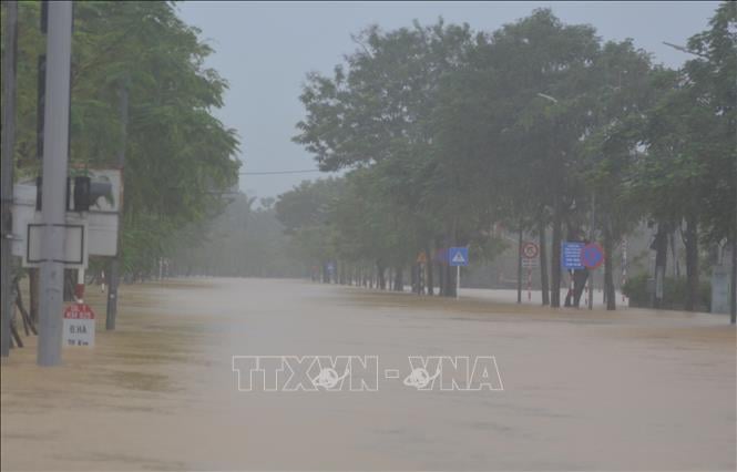
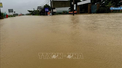
Regarding the flood situation, the National Center for Hydro-Meteorological Forecasting said that with the decreasing rain trend, the main rivers in Hue city, Da Nang city and Quang Ngai such as Huong river, Bo river, Vu Gia - Thu Bon river and Tra Khuc river have all peaked and are showing a tendency to slowly decrease.
In the next 12 hours, floods on Vu Gia - Thu Bon rivers will continue to decrease and be above alert level 3; floods on rivers in Hue city will continue to decrease and be below alert level 3; floods on Tra Khuc river will continue to decrease and be below alert level 2.
In the next 12-24 hours, flood on Thu Bon River will continue to decrease and be above alert level 3; flood on Vu Gia River will continue to decrease and be below alert level 3; rivers in Hue City will continue to decrease and be above alert level 2; flood on Tra Khuc River (Quang Ngai) will continue to decrease and be above alert level 1.
For rivers in Quang Tri province, in the next 24 hours: Thach Han River (at Thach Han) is at 5.8 m, 0.2 m above alert level 3; Kien Giang River (at Le Thuy) is at 2.9 m, 0.2 m above alert level 3; O Lau River (at My Chanh) is at alert level 2. Other rivers fluctuate around alert level 1-alarm level 2.
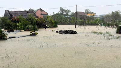
Warning: From October 30 to November 1, floods will appear on rivers from Nghe An to Northern Quang Tri. Floods will appear on the upper reaches of Ca River (Nghe An), Ngan Sau Ngan Pho River (Ha Tinh), Gianh and Kien Giang Rivers (Quang Tri) from alert level 2 to alert level 3, some rivers above alert level 3, and the lower reaches of Ca River (Nghe An), La River (Ha Tinh) will rise above alert level 1.
From November 2-4, floods on rivers from Ha Tinh to Quang Ngai are likely to rise again. "According to current forecast data, there is little possibility of a particularly large flood like the one on October 27-29. However, long-term forecasts from models are not yet highly reliable, so we need to continue monitoring and updating," emphasized Deputy Head of Weather Forecasting Department Vu Anh Tuan.
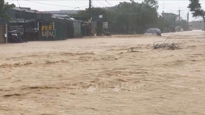
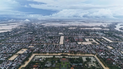
More information about the characteristics of the flood from October 27-30, according to the National Center for Hydro-Meteorological Forecasting, from October 27 to 29, on the main rivers in Hue city and Da Nang city, there were exceptionally large floods, with water levels in most rivers exceeding alert level 3, of which 5/12 measuring stations exceeded historical flood levels, including: Bo River (Hue city) at Phu Oc station reached 5.27m (at 7:00 p.m. on October 29), 0.03m higher than the historical flood level in 2020 (5.24m).
Vu Gia River (Da Nang city) at Thanh My station reached 27.2m (at 2:00 p.m. on October 29), 0.06m higher than the historical flood level in 2007 (27.14m); at Hoi Khach station reached 19.32m (at 3:00 p.m. on October 29), 1.18m higher than the historical flood level in 2009 (18.14m).
Thu Bon River (Da Nang city) at Nong Son station reached 18.68m (at 7:00 p.m. on October 29), 0.15m higher than the historical level in 1998 (18.53m); at Cau Lau station reached 5.62m (at 2:00 a.m. on October 30), 0.14m higher than the historical level in 1964 (5.48m).
Notably, the water level has remained above alert level 3 for a long time due to continuous heavy rain for many days. As of 7:00 a.m. on October 30, Kim Long (Huong River - Hue), Ai Nghia, Nong Son, Giao Thuy, Cau Lau, Hoi An (Vu Gia - Thu Bon river system) stations have maintained water levels above alert level 3 for 60-73 hours, of which Nong Son station has maintained the longest at 73 hours. It is forecasted that water levels on rivers in Da Nang City will remain above alert level 3 for another 6-12 hours.
Along with that, the National Center for Hydro-Meteorological Forecasting forecasts that from 11:30 a.m. to 4:30 p.m., the provinces/cities from Quang Tri to Gia Lai will continue to have rain. There is a risk of flash floods and landslides in the above-mentioned areas.
Specifically, the common accumulated rainfall in Ha Tinh, Quang Tri and Hue city is from 20-50mm, in some places over 120mm; Da Nang city is from 20-30mm, in some places over 80mm; Quang Ngai and Gia Lai are from 10-15mm, in some places over 40mm; Lam Dong is from 10-30mm, in some places over 70mm. Risk warning: flash floods on small rivers and streams, landslides on slopes in many communes/wards: Cam Hung, Cam Lac, Cam Trung, Cam Xuyen, Huong Khe, Huong Xuan, Ky Anh, Ky Hoa, Ky Khang, Ky Lac, Ky Thuong, Ky Van, Ky Xuan, Hai Ninh, Hoanh Son, Song Tri, Vung Ang; Cam Due, Ha Linh, Huong Do, Huong Pho, Son Kim 2, Son Tay, Thach Xuan; Co Dam, Hong Loc, Huong Binh, Mai Phu, Ha Huy Tap, Phuc Trach, Son Giang, Son Hong, Son Kim 1, Thach Khe, Vu Quang (Ha Tinh province); Bo Trach, Dakrong, Huong Phung, Kim Ngan, Dong Son, Quang Ninh, Ta Rut, Truong Ninh, Truong Son; Ba Long, Bac Trach, Ben Quan, Dong Trach, Hoan Lao, Huong Hiep, Khe Sanh, La Lay, Le Ninh, Nam Gianh, Nam Trach, Phong Nha, Phu Trach, Truong Phu; A Doi, Cam Lo, Con Tien, Dan Hoa, Dong Le, Hai Lang, Hieu Giang, Hoa Trach, Huong Lap, Kim Dien, Kim Phu, Lao Bao, Lia, Minh Hoa, Nam Ba Don, Nam Hai Lang, Quang Trach, Tan Gianh, Tan Lap, Tan Thanh, Thuong Trach, Trung Thuan, Tuyen Binh, Tuyen Hoa, Tuyen Lam, Tuyen Phu, Tuyen Son (Quang Tri province).
For Hue city and Da Nang city, including communes and wards: A Luoi 1, A Luoi 2, A Luoi 3, A Luoi 4, A Luoi 5, Binh Dien, Chan May - Lang Co, Hung Loc, Khe Tre, Loc An, Nam Dong, Kim Long, Kim Tra, Phong Dien, Phu Bai, Phu Loc; Long Quang, Huong An, Huong Tra, Phong Thai, Vinh Loc (Hue city); Ba Na, Hoa Vang, Hung Son, An Khe, Hai Van, Lien Chieu, Tam My; Avuong, Dai Loc, Dong Giang, Ha Nha, Hiep Duc, Hoa Tien, La Ee, Nong Son, Nui Thanh, Hoa Khanh, Phuoc Tra, Que Phuoc, Que Son, Son Cam Ha, Song Kon, Song Vang, Tay Giang, Thanh Binh, Thanh My, Thu Bon, Thuong Duc, Tien Phuoc, Viet An; Ben Giang, Ben Hien, Chien Dan, Dac Pring, Dien Ban Tay, Dong Duong, Duc Phu, Duy Xuyen, Kham Duc, La Dee, Lanh Ngoc, Nam Giang, Son Tra, Phu Ninh, Phu Thuan, Phuoc Chanh, Phuoc Hiep, Phuoc Nang, Phuoc Thanh, Que Son Trung, Tam Anh, Tam Xuan, Tay Ho, Thang Phu, Tra Giap, Tra Lien, Tra My, Tra Tan, Tra Van, Vu Gia (Da Nang city).
Communes and wards in Quang Ngai and Gia Lai provinces at risk of flash floods and landslides include: Tay Tra Bong; Ba Dong, Ba To, Ba To, Ba Vinh, Binh Minh, Ca Dam, Minh Long, Nguyen Nghiem, Phuoc Giang, Son Ha, Son Linh, Thanh Bong, Thien Tin, Tra Giang; Ba Dinh, Ba Gia, Ba Vi, Ba Xa, Binh Chuong, Dang Thuy Tram, Dinh Cuong, Dong Tra Bong, Khanh Cuong, Kon Plong, Lan Phong, Mo Duc, Nghia Giang, Duc Pho, Sa Huynh, Tra Cau, Son Ky, Son Mai, Son Tay, Son Tay Ha, Son Tay Thuong, Son Thuy, Son Tinh, Tay Tra, Tra Bong, Truong Giang, Ve Giang (Quang Ngai province); An Hoa, Bong Son, Van Duc; An Toan, An Tuong, Hoai
An; An Hao, An Lao, An Vinh, Binh Duong, Binh Hiep, Binh Phu, Hoi Son, KBang, Kim Son, Kong Bo La, Hoai Nhon, Hoai Nhon Bac, Hoai Nhon Dong, Hoai Nhon Nam, Hoai Nhon Tay, Tam Quan, Phu My, Phu My Bac, Phu My Dong, Phu My Tay, Vinh Quang, Vinh Son, Vinh Thinh (Gia Lai province).
In addition, Lam Dong province has communes and wards at risk of flash floods and landslides, including: Ham Kiem, Ham Thuan; Ham Liem, Ham Thanh, Ham Thuan Bac, Binh Thuan, Phuoc Hoi, Tien Thanh, Son My; Cat Tien, Cat Tien 2, Cat Tien 3, Da Huoai, Da Teh, Da Teh 3, Dinh Van Lam Ha, Dong Giang, Ham Tan, Ham Thuan Nam, Hong Son, La Da, Ward 1 Bao Loc, Ham Thang, La Gi, Phan Thiet, Phu Thuy, Son Dien, Ta Hine, Tan Hai, Tan Hoi, Tan Lap, Tan Minh, Tan Thanh, Tuyen Quang.
Level of risk of natural disasters due to flash floods, landslides, land subsidence due to heavy rain or water flow is level 1; Quang Ngai level 2; Hue city and Da Nang city level 3.
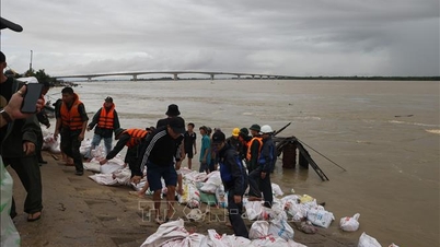
Flash floods and landslides can have very negative impacts on the environment, threaten people's lives; cause local traffic congestion, affect the movement of vehicles; destroy civil and economic works, causing damage to production and socio-economic activities.
The hydrometeorological agency recommends that local authorities pay attention to reviewing bottlenecks and vulnerable locations in the area to have prevention and response measures.
Source: https://baotintuc.vn/xa-hoi/du-bao-mien-trung-tiep-tuc-co-mua-lon-dien-rong-tu-ngay-3010-411-20251030121434511.htm
![[Photo] General Secretary To Lam attends the Vietnam-UK High-Level Economic Conference](https://vphoto.vietnam.vn/thumb/1200x675/vietnam/resource/IMAGE/2025/10/30/1761825773922_anh-1-3371-jpg.webp)

![[Photo] Prime Minister Pham Minh Chinh attends the 5th National Press Awards Ceremony on preventing and combating corruption, waste and negativity](https://vphoto.vietnam.vn/thumb/1200x675/vietnam/resource/IMAGE/2025/10/31/1761881588160_dsc-8359-jpg.webp)

![[Photo] The Third Patriotic Emulation Congress of the Central Internal Affairs Commission](https://vphoto.vietnam.vn/thumb/1200x675/vietnam/resource/IMAGE/2025/10/30/1761831176178_dh-thi-dua-yeu-nuoc-5076-2710-jpg.webp)


Comment (0)