
On November 3, in the 10-day weather forecast (November 3-13) of the Southern Hydrometeorological Station, it was reported that cold high pressure will strengthen again in the North of our country on November 5-6.
The equatorial low pressure trough with its axis at about 5-8 degrees North latitude will last until about November 7-8, then retreat to the South and become weak.
Northeast wind is weak, from about November 6 it will gradually increase in intensity in the Southern sea areas.
Above, the subtropical high pressure has an axis through the Central Central region and its intensity has changed little. The high-altitude easterly wind disturbance is gradually weakening in the Southern region, and from around November 7-8, it is likely to become active again.
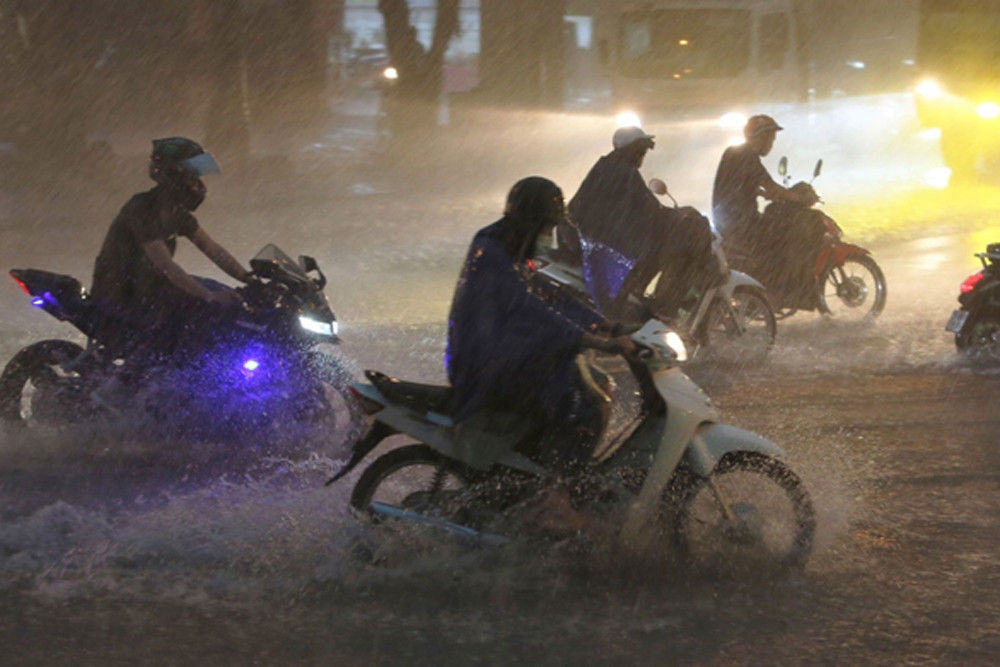
The above combination of patterns will cause the weather across the country to change from the night of November 5, notably the North and Central Central regions will see heavy rain and thunderstorms. The North will welcome cold air this time, according to meteorological experts, the temperature will only drop slightly so it will be chilly at night and in the morning.

The National Center for Hydro-Meteorological Forecasting has just issued a weather forecast for the night of November 5-13. Accordingly, in the Northern region, around the night of November 5 and the day of November 6, there will be scattered showers and thunderstorms, with moderate to heavy rain in some mountainous areas.
Following the movement of cold air, the North and Central Central regions, from November 6-8, will have rain, moderate rain, heavy rain and thunderstorms in some places.
The South Central Coast and Central Highlands will have scattered showers and thunderstorms, with some areas having moderate to heavy rain from the late afternoon and evening of November 7-9.
From November 7-12, the Southern region will have scattered showers and thunderstorms, with localized heavy rain, mainly in the late afternoon and at night.
In the immediate future, from this evening and tonight until November 5, the North and North Central regions will be stable with some rain at night, some fog in the early morning, sunny in the afternoon; in mountainous areas, there will be showers and thunderstorms in some places.
Southern region, scattered showers and thunderstorms in the late afternoon and at night; from November 5, scattered showers and thunderstorms in some places.
In addition, other areas have sunny days, showers and thunderstorms in the evening and at night in some places.
Previously, the meteorological agency predicted that in November, cold air would continue to increase in frequency compared to October, but there was little possibility of strong cold air waves causing temperatures to drop sharply.
In addition, this period is also the main rainy season in the Central region, so heavy rains due to the influence of weather patterns such as cold air combined with tropical convergence zones and high-altitude easterly wind disturbances will still occur, so it is necessary to guard against the risk of flash floods and landslides in the area.

East Sea likely to welcome 1-2 storms, cold air increases in November
According to meteorological experts, October has seen days of rain exceeding historical values in the Central region. It is forecasted that in November, there will be a possibility of 1-2 storms/tropical depressions appearing in the East Sea; cold air will also increase.
The whole country has 3 sunny days before welcoming cold air with rain
The rain in the Central and Southern regions will decrease from tonight and the whole country will have about 3 sunny days. After that, a cold air mass will bring "rolling" rain from the North and South.
Source


![[Photo] Top players gather at the 2025 Nhan Dan Newspaper National Table Tennis Championship](https://vphoto.vietnam.vn/thumb/1200x675/vietnam/resource/IMAGE/2025/5/23/9ad5f6f4faf146b08335e5c446edb107)


Comment (0)