
Talking to reporters of Knowledge and Life, Prof. Dr. Do Minh Duc, University of Natural Sciences (Hanoi National University) said that, based on the reality of many terrible landslides in mountainous areas, he and his colleagues developed the application "Vietnam Landslide" on the platform of AI, IoT and big data to provide real-time warnings, response instructions and help people and authorities minimize natural disaster risks.

Detailed warnings to each village
“Based on painful lessons such as Tra Leng (2020), Mu Cang Chai (2017) or the severe impacts of storm Yagi in 2024, we want to turn data into action,” Professor Duc shared about the reason why he and his colleagues designed the App “Vietnam Landslide”.
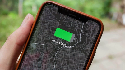
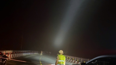
. Photo: NVCC.")
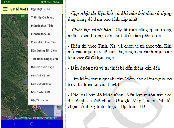
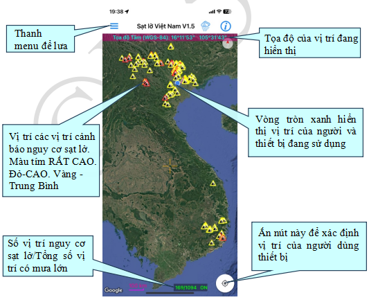
Professor Duc said that the application updates data every 20 minutes, covering all the sloping land of Vietnam, showing detailed information for each location, residential area, and village, not just a general map. This is an important difference, when the warning reaches the "High" or "Very High" level, people in each specific village or hamlet will know exactly which area to move.
Specifically, the application classifies risk levels into three levels: Medium, High and Very High.
Medium: Warning of possible local landslides, mainly small in scale. Be vigilant in dangerous areas. Be cautious at slopes higher than 6m, newly excavated slopes or those with landslides. Pay attention to the next hourly bulletin. Send information to relevant parties.
High Level: Warning of the risk of landslides and flash floods that are likely to occur in reality. Deploy response plans (prepared and specifically built in advance for each location), do not let people and property stay near low-lying areas along rivers, streams, temporary flows and dangerous slopes (higher than 6m, slope over 45 degrees), when there is a large slide from Medium level or higher, limit traffic in high-risk areas and roads. Pay attention to the next hourly bulletin. Normally, high risk can continue for 3-6 hours even after the rain has stopped completely.
When reaching Very High level: Landslides and flash floods actually occur, possibly on a large scale. It is necessary to deploy response plans for each specific case. Combined with information when large landslides of high level or higher occur, move people in dangerous areas to safety; prohibit people and vehicles from traveling through dangerous roads and slopes. Very high risk can continue for 6-12 hours or longer, even when the rain has stopped completely.
The application has a sound notification mode when entering a dangerous area or heavy rain, with different frequencies when moving or standing still.
“We designed different warning frequencies when moving and when standing still. When moving, it will repeat every 15-17 seconds; when standing still, it will repeat every 1 minute, to ensure that people driving or working outdoors still receive timely warnings. The application also distinguishes between heavy rain warnings, with reminders when the total rainfall exceeds a preset threshold (for example, >50 mm/day for heavy rain warnings), helping to forecast the risk of flash floods and traffic jams,” said Prof. Duc.
Another highlight of the application, according to Professor Duc, is the ability to set a rain monitoring radius. Users can choose from 100 m to 3,000 km depending on their needs. In mountainous areas, it is recommended to monitor rainfall within a radius of 3,000–5,000 meters to detect unusual trends in local catchments.
The application also provides rainfall information according to time windows: 1 hour, 3 hours, 6 hours, 24 hours, and gives warning thresholds based on research: 180 mm/24h; 60 mm/1h; 90–100 mm/3h; 110–120 mm/6h. These figures reflect the experience in many areas of Vietnam and help assess the risk of landslides and flash floods.
A few small steps, reduce a series of big risks
Professor Duc said that the “Vietnam Landslide” application is currently available on both Google Play (Android) and Apple Store (iOS). After downloading, users need to update data as soon as they open the app to ensure the latest information.
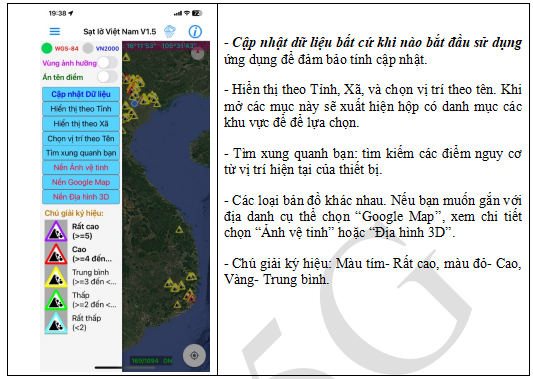

On the main interface, users can locate the device, track nearby landslide warning points, or search by province, commune, or village. The application allows setting an arbitrary warning radius, from 100 meters to 3,000 km, suitable for both small residential areas and large mountainous areas.
When the rain warning mode is turned on, the system will notify if the rainfall exceeds 50mm/day or the hourly danger threshold. According to research in Vietnam, the rainfall threshold that can easily cause landslides is usually 180mm/24h or short-term rain is 60mm/1h, 90-100mm/3h, 110-120mm/6h. When many criteria exceed the threshold at the same time, the risk increases sharply, requiring a quick response.
The application also supports different types of maps, such as Google Map, satellite images or 3D terrain, helping users locate real-life terrain. In addition, the navigation and search function for surrounding danger points helps users, rescue agencies and authorities in identifying, monitoring and checking dangerous areas in emergency situations.
“We hope that every mountain resident, every mountain pass driver, and every disaster prevention officer will install and master this application. Because natural disasters are inevitable, but the consequences can be greatly reduced if people are proactive,” Professor Duc emphasized.
Professor Duc noted that when receiving a High or Very High level warning, users need to activate the prepared response plan, monitor information hourly and only return to the area when the risk warning is no longer present.
According to Professor Do Minh Duc, the application is a support tool, not a replacement for official bulletins, but has great advantages, which are fast update time, high location resolution, and the ability to integrate many types of maps. When the warning pops up, people will know the area at risk, the level of impact and the surrounding area, thereby proactively moving or notifying others.
“Natural disasters are unavoidable, but the extent of damage largely depends on human behavior and initiative. Installing and skillfully using the “Vietnam Landslide” application not only helps each individual and family to be safer but also contributes to minimizing losses for the community,” said Professor Do Minh Duc.
Source: https://khoahocdoisong.vn/gs-thiet-ke-app-sat-lo-viet-nam-mot-tieng-chuong-co-the-cuu-mang-nguoi-post2149064350.html
![[Photo] Flooding on the right side of the gate, entrance to Hue Citadel](https://vphoto.vietnam.vn/thumb/1200x675/vietnam/resource/IMAGE/2025/10/28/1761660788143_ndo_br_gen-h-z7165069467254-74c71c36d0cb396744b678cec80552f0-2-jpg.webp)
![[Photo] Draft documents of the 14th Party Congress reach people at the Commune Cultural Post Offices](https://vphoto.vietnam.vn/thumb/1200x675/vietnam/resource/IMAGE/2025/10/28/1761642182616_du-thao-tai-tinh-hung-yen-4070-5235-jpg.webp)

![[Photo] National Assembly Chairman Tran Thanh Man received a delegation of the Social Democratic Party of Germany](https://vphoto.vietnam.vn/thumb/1200x675/vietnam/resource/IMAGE/2025/10/28/1761652150406_ndo_br_cover-3345-jpg.webp)


![[Photo] President Luong Cuong attends the 80th Anniversary of the Traditional Day of the Armed Forces of Military Region 3](https://vphoto.vietnam.vn/thumb/1200x675/vietnam/resource/IMAGE/2025/10/28/1761635584312_ndo_br_1-jpg.webp)


Comment (0)