
Watch clip: Mr. Vu Anh Tuan, Deputy Head of Weather Forecast Department, National Center for Hydro-Meteorological Forecasting, answers about developments after storm No. 4 :
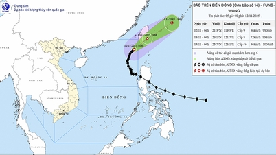
Storm No. 4 made landfall in Quang Binh - Quang Tri early this afternoon (September 19), then quickly weakened into a tropical depression. It is forecasted that in the coming hours (from 3 p.m.), the tropical depression will continue to weaken into a low pressure area and gradually dissipate as it moves deeper inland.
However, experts warn that storm No. 4's circulation will still cause very heavy rain in the mainland provinces of the North and Central Central regions.
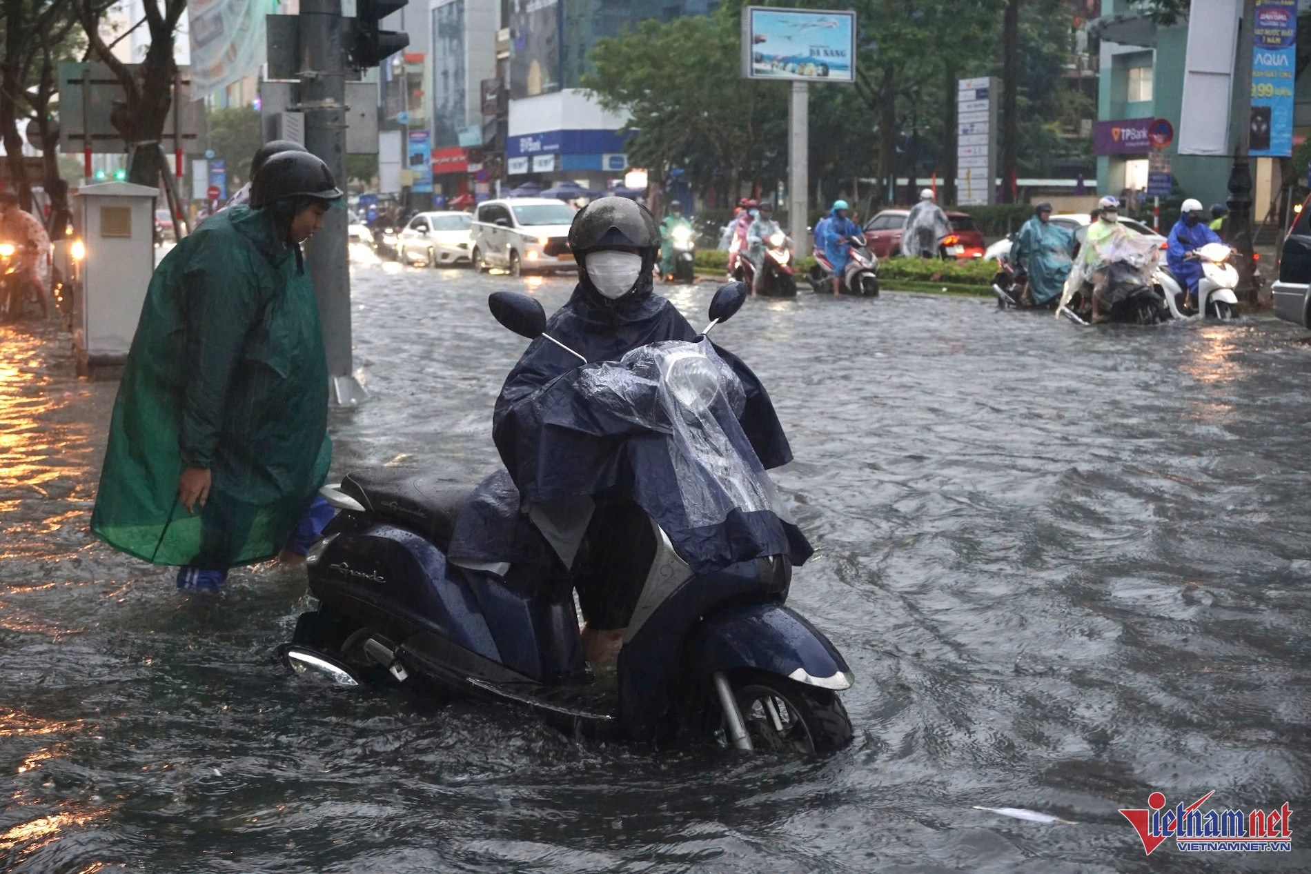
In the 3:30 pm bulletin this afternoon, the National Center for Hydro-Meteorological Forecasting said that last night and today (September 19), in the area from Ha Tinh to Da Nang, there was heavy to very heavy rain and thunderstorms. The rainfall from 7:00 pm last night to 3:00 pm in some places was over 200mm such as: Mai Hoa (Quang Binh) 222.8mm, Ta Long (Quang Tri) 363.6mm, Bach Ma (Thua Thien Hue) 321.3mm,...
The meteorological agency forecasts that from this evening and tonight until tomorrow (September 20), the area from Ha Tinh to Quang Tri will continue to have heavy to very heavy rain and scattered thunderstorms with rainfall of 100-200mm, in some places over 350mm. From the night of September 20, heavy rain will gradually decrease.
From this evening and tonight until tomorrow night, Thanh Hoa and Nghe An will have heavy rain and scattered thunderstorms, locally very heavy rain with rainfall of 100-200mm, locally over 300mm. From September 21, heavy rain will gradually decrease.
In addition, this evening and tonight, in the plains and coastal areas of the North, Thua Thien Hue will have scattered showers and thunderstorms, locally heavy rain with rainfall from 10-30mm, locally over 70mm. The Central Highlands and the South will have scattered showers and thunderstorms, locally heavy rain with rainfall from 15-30mm, some over 70mm; the rain will be concentrated in the afternoon and at night. During thunderstorms, there is a possibility of tornadoes, lightning and strong gusts of wind.
The meteorological agency warns people to be on guard against heavy rain (>100mm/6 hours) in the area from Ha Tinh to Quang Tri this afternoon and tonight.
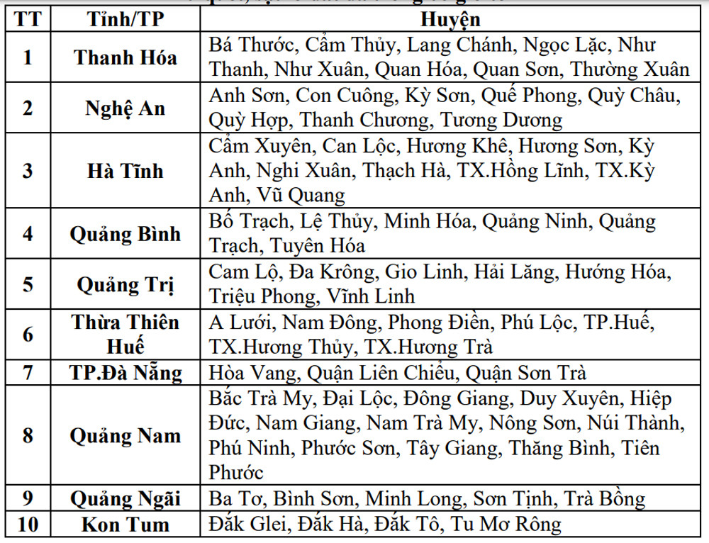
73 communes at risk of flash floods and landslides in the next 6 hours
At the same time, in this afternoon's bulletin, the National Center for Hydro-Meteorological Forecasting warned of flash floods, landslides, and land subsidence due to heavy rain or water flow in the provinces from Thanh Hoa to Quang Ngai and Kon Tum.
Notably, on the flash flood and landslide warning map, this area is colored "purple", a color indicating a very high warning level.
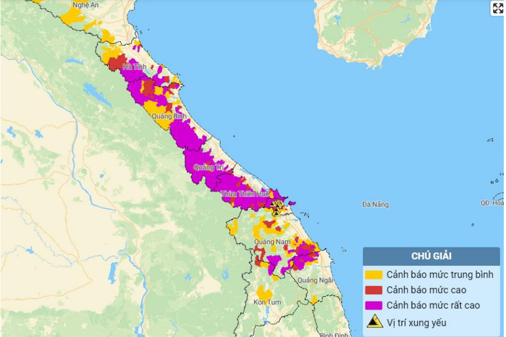
Warning level of natural disaster risk due to flash floods, landslides, land subsidence due to heavy rain or water flow: Level 1. Particularly for Da Nang City and Thua Thien Hue: Level 2.
There are 73 communes in the Central and Central Highlands regions under warning of flash floods and landslides.
Earlier, at noon the same day, Director of the National Center for Hydro-Meteorological Forecasting Mai Van Khiem warned: "We want to emphasize that, along with the movement of the storm circulation after making landfall, it will cause widespread heavy rain in the North and Central Central regions, especially the area from the North of Thua Thien Hue to the provinces of Quang Binh, Quang Tri, Ha Tinh,...".
In particular, heavy rain concentrated in a short period of time, there is a very high risk of flash floods and landslides in the western mountainous areas.

Storm No. 4 makes landfall in Quang Binh - Quang Tri, very heavy rain in 4 provinces
Around 1-3pm this afternoon, storm No. 4 (Soulik) will make landfall in the provinces of Quang Binh - Quang Tri with the strongest wind speed of level 8, gusting to level 10-11. Some areas in Thua Thien Hue, Quang Binh, Quang Tri, and Ha Tinh will continue to experience very heavy rain.


![[Photo] Deep sea sand deposits, ancient wooden ship An Bang faces the risk of being buried again](https://vphoto.vietnam.vn/thumb/1200x675/vietnam/resource/IMAGE/2025/11/13/1763033175715_ndo_br_thuyen-1-jpg.webp)


![Dong Nai OCOP transition: [Article 3] Linking tourism with OCOP product consumption](https://vphoto.vietnam.vn/thumb/402x226/vietnam/resource/IMAGE/2025/11/10/1762739199309_1324-2740-7_n-162543_981.jpeg)


Comment (0)