
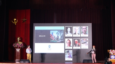
The research project "Application of advanced technology to build an early warning system for natural disaster risks such as floods and inundation in Quang Tri province and surrounding areas," led by Assoc. Prof. Dr. Nguyen Thanh Hung of the Vietnam Institute of Water Resources Science , aims to build a data and technology platform to support real-time forecasting and warning.

Early warning system for natural disasters and floods in Quang Tri province.
The main products of the project include a hydrometeorological dataset, a map for constructing the study area for natural disaster risk warning; a flood and inundation risk map for Quang Tri province and neighboring areas; real-time early warning technology software for natural disaster risks based on hydrometeorological forecast bulletins; technology for transmitting warning information on WebGIS and mobile phones; and a report proposing appropriate response plans.
The research results have been transferred and applied at the Quang Tri Provincial Department of Irrigation and Disaster Prevention, the Quang Tri Meteorological and Hydrological Station, and several related specialized agencies. The deployment of WebGIS software and technology helps management units access forecast information quickly and visually, supporting decision-making in emergency situations. For the community, the technology transmits warning information via mobile phones, enabling people to receive timely warnings during the rainy season and floods, contributing to minimizing damage.


The system utilizes data platform applications, WebGIS technology, mobile technology, and Cloud Server solutions.
According to the report, the application system, utilizing data platforms, WebGIS technology, mobile technology, and cloud server solutions, has created a continuous, stable, and scalable information transmission channel, meeting the specific requirements of local disaster warning work.
The effectiveness of the project is clearly demonstrated in supporting management agencies to improve professional quality and enhance their proactive disaster prevention and response capabilities; while also contributing to ensuring community safety and minimizing socio -economic losses.
The early warning system developed plays a crucial role in enhancing disaster prevention and response capabilities in Quang Tri, especially in high-risk areas. The integration of data platforms, GIS technology, mobile applications, and cloud server infrastructure has created a synchronized, stable, and scalable solution, clearly demonstrating the effectiveness of science and technology in protecting social safety from the impacts of natural disasters.
Source: https://mst.gov.vn/hoan-thien-he-thong-canh-bao-som-rui-ro-thien-tai-ngap-lut-cho-tinh-quang-tri-197251212004544129.htm

![[Photo] Prime Minister Pham Minh Chinh holds a phone call with the CEO of Russia's Rosatom Corporation.](/_next/image?url=https%3A%2F%2Fvphoto.vietnam.vn%2Fthumb%2F1200x675%2Fvietnam%2Fresource%2FIMAGE%2F2025%2F12%2F11%2F1765464552365_dsc-5295-jpg.webp&w=3840&q=75)


Comment (0)