

The National Center for Hydro-Meteorological Forecasting said that the cold air mass continues to move south.
In the next 24 to 48 hours (around the morning of October 26), this cold air mass will affect the Northeast region, then affect the North Central region and some places in the Northwest and Central Central regions. Northeast wind inland is strong at level 2 - 3, coastal areas at level 3 - 4.
Due to the influence of cold air, the lowest temperature in the Northern region, Thanh Hoa and Nghe An is commonly from 19 - 22 degrees Celsius.
Hanoi area is cold at night and morning, the lowest temperature in this cold air mass is commonly from 19 - 21 degrees Celsius.
At sea, from early morning on October 26, the Northeast wind in the Gulf of Tonkin gradually increased to level 6, gusting to level 7 - 8, rough seas, waves 1.5 - 3 m high; the sea area north of the North East Sea had strong Northeast wind of level 6, sometimes level 7, gusting to level 8 - 9, rough seas, waves 3 - 5 m high; the sea area from South Quang Tri to Da Nang city had Northeast wind of level 5, sometimes level 6, gusting to level 7 - 8, rough seas, waves 2 - 4 m high.
Due to the influence of cold air strengthening combined with disturbances in the upper easterly wind zone, the area from South Quang Tri to Da Nang and the eastern part of the provinces from Quang Ngai to Dak Lak will have moderate rain, heavy rain and thunderstorms, and locally very heavy rain.
Thunderstorms accompanied by tornadoes, lightning, hail and strong gusts of wind can affect agricultural production, break trees, damage houses, traffic works and infrastructure.
Strong winds and gusts, large waves at sea may affect boating and other activities. Colder weather at night and in the morning may affect health.
Many areas have heavy rain, some places over 450 mm
Also according to information from the National Center for Hydro-Meteorological Forecasting, from the evening of October 25 to October 27, in the area of Hue city, Da Nang city and the eastern part of Quang Ngai and Gia Lai provinces, there will be heavy to very heavy rain with common rainfall of 100 - 300 mm, locally over 450 mm.
The Southern Quang Tri and Eastern Dak Lak regions will have moderate to heavy rain and thunderstorms with a general rainfall of 60 - 120 mm, and locally very heavy rain of over 200 mm. Warning of the risk of heavy rain over 150 mm in 3 hours.
In addition, in the evening and night of October 25, the western region from Quang Ngai to Dak Lak, Khanh Hoa, Lam Dong provinces and the Southern region will have rain, moderate rain and thunderstorms with rainfall of 20 - 40 mm, locally heavy to very heavy rain of over 100 mm. During thunderstorms, there is a possibility of tornadoes, lightning, hail and strong gusts of wind. Warning of the risk of heavy rain over 80 mm in 3 hours.
On the night of October 27 and October 28, in the area from Quang Tri to Quang Ngai, there will be moderate rain, heavy rain and thunderstorms with common rainfall from 50 - 150 mm, locally very heavy rain over 300 mm. Heavy rain in this area is likely to last until the end of October 2025. The risk level of natural disasters due to heavy rain, tornadoes, lightning, and hail is level 1.
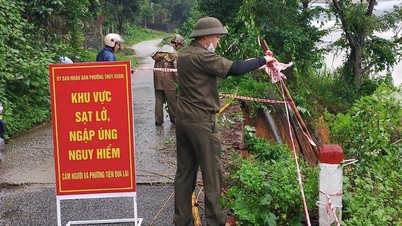
Heavy rains can cause flooding in low-lying areas, urban and industrial areas; flash floods in small rivers and streams; landslides on steep slopes. Areas that are on alert during thunderstorms are at risk of tornadoes, lightning, hail and strong gusts of wind.
Flood warning on rivers from Quang Tri to Khanh Hoa
The National Center for Hydro-Meteorological Forecasting said that from October 25 to October 28, a flood will occur on rivers from Quang Tri to Quang Ngai and along the coast of provinces from Gia Lai to Khanh Hoa. The peak flood level on Kien Giang River, Thach Han River (Quang Tri), Bo River, Huong River (Hue City), Tra Khuc River, Ve River (Quang Ngai) will rise to alert level 1 - alert level 2, some places above alert level 2; Vu Gia - Thu Bon River (Da Nang City), Kon River (Gia Lai), Ba River (Dak Lak) will rise to alert level 1; Ky Lo River (Dak Lak), Dinh Ninh Hoa River (Khanh Hoa) may rise to alert level 2 - alert level 3.
High risk of flooding in provinces from Quang Tri to Khanh Hoa, high risk of flash floods on rivers and streams and landslides on slopes in provinces from Quang Tri to Khanh Hoa.
Floods on rivers and streams can cause flooding in low-lying areas along rivers, affecting activities such as waterway transport, aquaculture, agricultural production, people's lives and socio-economic activities. Flood disaster risk level 1 - 2.
Currently, the water level on rivers from Quang Tri to Khanh Hoa is fluctuating. The water level at 1:00 p.m. on October 25 on Kien Giang River (Quang Tri) at Le Thuy station was 1.73 m, 0.47 m below alarm level 2; on Bo River (Hue city) at Phu Oc station was 2.74 m, 0.26 m below alarm level 2; on Huong River (Hue city) at Kim Long station was 1.37 m, 0.37 m above alarm level 1.
Risk of flooding in low-lying coastal areas in the Southeast region
According to the 3:30 p.m. bulletin of the National Center for Hydro-Meteorological Forecasting, the highest water level at Vung Tau station is forecast to be 4 - 4.1 m in the next 24 hours.
In the next 24 - 72 hours, the water level in the eastern coast of the South will continue to change slowly. The highest water level at Vung Tau station is likely to reach 3.95 - 4.05 m.
It is forecasted that due to the impact of high tides, the eastern coastal area of the South needs to pay attention to prevent high risks of flooding and dike overflow in low-lying coastal areas, riverside areas, and outside the dikes, affecting traffic, agricultural production, aquaculture, water pollution and people's lives in the eastern coastal area of the South.
Many sea areas have strong winds and high waves.
At sea, on the night of October 25 and October 26, in the sea area from Quang Tri to Ca Mau, Ca Mau to An Giang, the Gulf of Thailand, the sea area south of the North East Sea area (including Hoang Sa special zone), the area between the East Sea and the South East Sea area (including Truong Sa special zone), there will be scattered showers and thunderstorms, with the possibility of tornadoes, strong gusts of wind of level 6-7 and waves over 2m high during thunderstorms.
All vessels operating in the above areas are at high risk of being affected by strong winds and large waves.
Weather in regions across the country on the night of October 25 and October 26:
Hanoi capital has no rain, sunny afternoon, cold night and morning. Northeast wind level 2 - 3. Lowest temperature 19 - 21 degrees Celsius. Highest temperature 24 - 26 degrees Celsius.
In the Northwest, there will be some rain; sunny in the afternoon, cold at night and in the morning. Light wind. Lowest temperature 16 - 19 degrees Celsius, some places below 16 degrees Celsius. Highest temperature 23 - 26 degrees Celsius, some places above 26 degrees Celsius.
In the Northeast, there will be some rain; sunny in the afternoon, cold at night and in the morning, and chilly in the mountainous areas. Northeast wind level 2 - 3. Lowest temperature 18 - 21 degrees Celsius, in mountainous areas below 18 degrees Celsius. Highest temperature 23 - 26 degrees Celsius, in some places above 26 degrees Celsius.
Provinces and cities from Thanh Hoa to Hue , in the North there will be rain in some places, cold weather; in the South there will be moderate rain, heavy rain and thunderstorms, locally very heavy rain in some places, in thunderstorms there is a possibility of tornadoes, lightning and strong gusts of wind. North to Northwest wind level 2 - 3. Lowest temperature 18 - 21 degrees Celsius. Highest temperature 23 - 26 degrees Celsius.
The South Central Coast has heavy to very heavy rain and thunderstorms; the South has rain, moderate rain and scattered thunderstorms, locally heavy to very heavy rain, with the possibility of tornadoes, lightning and strong gusts of wind in thunderstorms. Northeast wind level 2 - 3. Lowest temperature 22 - 25 degrees Celsius. Highest temperature in the North 24 - 27 degrees Celsius; in the South 29 - 32 degrees Celsius.
The Central Highlands has rain, moderate rain and scattered thunderstorms, locally heavy to very heavy rain, with the possibility of tornadoes, lightning, hail and strong gusts of wind. Northeast wind level 2 - 3. Lowest temperature 19 - 22 degrees Celsius, some places below 19 degrees Celsius. Highest temperature 24 - 27 degrees Celsius.
The South has scattered showers and thunderstorms; in the afternoon and at night there will be rain, moderate rain and scattered thunderstorms, locally heavy to very heavy rain, with the possibility of tornadoes, lightning, hail and strong gusts of wind. Northeast to East wind level 2 - 3. Lowest temperature 23 - 26 degrees Celsius. Highest temperature 29 - 32 degrees Celsius.
Ho Chi Minh City has showers and thunderstorms in some places; in the afternoon and at night there is rain, moderate rain and scattered thunderstorms, locally heavy to very heavy rain in some places, in thunderstorms there is a possibility of tornadoes, lightning, hail and strong gusts of wind. Northeast to East wind level 2 - 3. Lowest temperature 24 - 26 degrees Celsius. Highest temperature 30 - 32 degrees Celsius.
Source: https://baolaocai.vn/khong-khi-lanh-tang-cuong-vung-nui-bac-bo-co-noi-duoi-17-do-c-post885319.html

![[Photo] Prime Minister Pham Minh Chinh and United Nations Secretary-General Antonio Guterres attend the Press Conference of the Hanoi Convention Signing Ceremony](https://vphoto.vietnam.vn/thumb/1200x675/vietnam/resource/IMAGE/2025/10/25/1761391413866_conguoctt-jpg.webp)


![[Photo] National Assembly Chairman Tran Thanh Man receives United Nations Secretary-General Antonio Guterres](https://vphoto.vietnam.vn/thumb/1200x675/vietnam/resource/IMAGE/2025/10/25/1761390815792_ctqh-jpg.webp)
![[Photo] Prime Minister Pham Minh Chinh receives United Nations Secretary-General Antonio Guterres](https://vphoto.vietnam.vn/thumb/1200x675/vietnam/resource/IMAGE/2025/10/25/1761390212729_dsc-1484-jpg.webp)


![[Photo] General Secretary To Lam meets with General Secretary and President of Laos Thongloun Sisoulith](https://vphoto.vietnam.vn/thumb/1200x675/vietnam/resource/IMAGE/2025/10/25/1761380913135_a1-bnd-4751-1374-7632-jpg.webp)


Comment (0)