
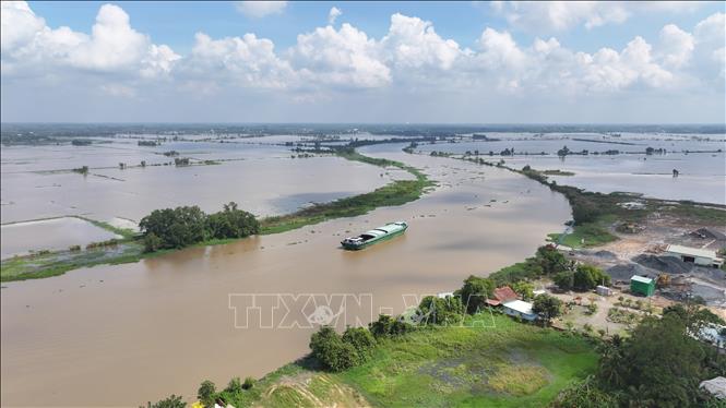
According to records in the past 24 hours, the water level downstream of rivers continues to rise slowly with the tide but has exceeded the alarm level in many places. Specifically, Go Dau Ha station reached 1.36 m (above alarm level II), Ben Luc station 1.65 m and Tan An 1.88 m (above alarm level III). In Moc Hoa area - in Dong Thap Muoi region, the water level has reached 2.03 m, higher than alarm level III, causing local flooding in low-lying areas.
It is forecasted that in the coming days, the water level in the southern region will continue to rise slowly with the tide and remain at a high level, generally at alert level II, and in some places exceeding alert level III. Particularly in the Dong Thap Muoi region, due to the influence of heavy rain and water flowing from upstream, floods are likely to remain at a high level for many days to come.
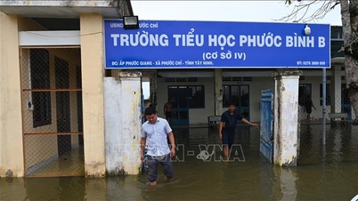
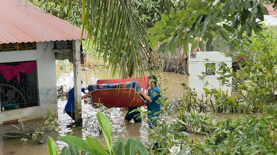
The meteorological agency warned of the risk of widespread flooding in riverside communes in Can Duoc, Can Giuoc, Tan Tru, Ben Luc, Duc Hoa and many low-lying areas in Duong Minh Chau, Trang Bang, Tan Bien, Phuoc Vinh, Hoa Hoi, Ninh Dien, Long Thuan communes. Some rivers and canals such as Vam Co Dong, Vam Co Tay, Ben Da canal are at risk of dangerous landslides and bank collapses.
In particular, the communes of Hung Dien, Nhon Hoa Lap, Vinh Chau, Hau Thanh, Tan Thanh and Thanh Hoa are advised to be on guard against the risk of dike breaks and bank overflows due to rising water levels combined with prolonged heavy rain.
According to the announcement, the level of natural disaster risk due to floods on the Vam Co Dong and Vam Co Tay rivers is determined at level 2. Tay Ninh Hydrometeorological Station recommends that local authorities and people proactively prepare response plans to ensure safety of life, property and agricultural production during high flood periods.
Source: https://baotintuc.vn/xa-hoi/lu-tren-song-vam-co-dong-vam-co-tay-vuot-bao-dong-iii-nguy-co-ngap-sau-vo-de-20251108175657977.htm


![[Photo] Cutting hills to make way for people to travel on route 14E that suffered landslides](https://vphoto.vietnam.vn/thumb/1200x675/vietnam/resource/IMAGE/2025/11/08/1762599969318_ndo_br_thiet-ke-chua-co-ten-2025-11-08t154639923-png.webp)


![[Video] Hue Monuments reopen to welcome visitors](https://vphoto.vietnam.vn/thumb/402x226/vietnam/resource/IMAGE/2025/11/05/1762301089171_dung01-05-43-09still013-jpg.webp)


Comment (0)