
On the afternoon of September 17, the Southern Hydrometeorological Station (Department of Hydrometeorology) has just released its assessment of the main weather developments affecting the regions in the next 10 days.
Specifically, in the next 1-2 days, the tropical convergence zone with its axis through the South Central region connecting with the low pressure area in the middle of the East Sea will move in a West-Northwest direction towards the coastal provinces of the Central region. At the same time, the tropical low pressure in the north of Luzon Island (Philippines) will enter the East Sea and may gradually strengthen. The Southwest monsoon has an average intensity.
It is forecasted that in the next 3-10 days, the tropical convergence zone will lift its axis to the North through the Central Central region, becoming active, connecting with the low pressure area in the central East Sea moving in a West-Northwest direction towards the coastal provinces of the Central region, and the tropical depression active in the North East Sea.

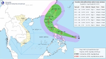
Around September 23-24, the storm east of the Philippines is likely to enter the East Sea. Above, the subtropical high pressure system with an axis over the North continues to move westward and has a stable intensity. The southwest monsoon in the South operates at a moderate intensity, gradually weakening from around September 20-21.
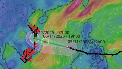
Meanwhile, according to the latest forecast from the National Center for Hydro-Meteorological Forecasting, the tropical depression in the Luzon Island area (Philippines) will enter the East Sea tonight, September 17, and is likely to strengthen into storm No. 8 in the next few hours.
Thus, in the next week, in addition to the active low pressure area, a tropical low pressure will appear in the East Sea tonight that is likely to strengthen into storm number 8; then, around September 23-24, a storm may be welcomed.
The North will have many rainy days from now until the end of the month.
The National Center for Hydro-Meteorological Forecasting has also just issued a warning about weather trends on land for a period of up to 10 days (from the night of September 17-27). Specifically:
From the night of September 17 to September 19 :
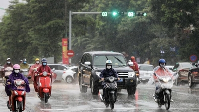
Northern region: scattered showers and thunderstorms, locally heavy rain (concentrated at night and morning).
Area from Thanh Hoa to Hue City: scattered showers and thunderstorms, locally heavy rain.
Area from Da Nang to Lam Dong and the South: afternoon and night there will be rain, moderate rain and scattered thunderstorms, locally heavy to very heavy rain.
From the night of September 19 to September 27 :
Northern region: on the night of September 19, there will be scattered showers and thunderstorms; from September 22-23, there will be rain, moderate rain and thunderstorms, with some places having heavy to very heavy rain; from September 24-25, there is a possibility of widespread heavy rain.
From Thanh Hoa to Ha Tinh : scattered showers and thunderstorms; from September 19 to September 22-23, scattered showers and thunderstorms, locally heavy to very heavy rain; from September 25, widespread heavy rain is possible.
Area from Quang Tri to Hue City: scattered showers and thunderstorms; scattered showers and thunderstorms in the late afternoon and evening.
From Da Nang City to Lam Dong and the South: in the afternoon and evening there will be scattered showers and thunderstorms, with heavy rain in some places.
The Meteorological Center also stated that on September 18-19 and from September 22-27, Hanoi will have showers, thunderstorms, and some days of heavy rain. The lowest temperature during the days will drop to 22 degrees and the highest will be 35 degrees. In the next 10 days, only on September 20-21, Hanoi is forecast to have hot weather.
In addition, the Southern Hydrometeorological Station also forecasts that in the Ho Chi Minh City area, in the next 1-2 days, there will be moderate rain, heavy rain and thunderstorms, locally very heavy rain. Total rainfall is generally 40-90mm, in some places over 90mm.
In the next 2-3 days, this area will continue to have moderate to heavy rain. The total rainfall for the period is generally 80-140mm, with some places over 150mm. From September 20, the rain will gradually decrease in area and amount.
Thunderstorms may produce tornadoes, lightning, hail, and strong gusts of wind. Localized heavy rain may cause flash floods in small rivers and streams, landslides on steep slopes, and inundation in low-lying areas.
The meteorological agency noted that the weather at the end of 2025 is forecast to have many unpredictable developments. Authorities and people need to regularly monitor hydrometeorological bulletins, especially short-term warnings, to respond promptly and ensure the safety of people and property.
Source: https://baolaocai.vn/mien-bac-sap-co-dot-mua-lon-xoi-xa-bien-dong-kha-nang-don-2-con-bao-lien-tiep-post882335.html


![[Photo] "Ship graveyard" on Xuan Dai Bay](https://vphoto.vietnam.vn/thumb/1200x675/vietnam/resource/IMAGE/2025/11/08/1762577162805_ndo_br_tb5-jpg.webp)


![[Video] Hue Monuments reopen to welcome visitors](https://vphoto.vietnam.vn/thumb/402x226/vietnam/resource/IMAGE/2025/11/05/1762301089171_dung01-05-43-09still013-jpg.webp)


Comment (0)