

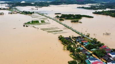
Warning: From the night of November 16 to November 20, there is a possibility of a flood on rivers in Da Nang City. The flood peak on Vu Gia-Thu Bon River fluctuates at level BĐ2 to BĐ3, some places above BĐ3 - Photo: VGP/The Phong
Flood on Vu Gia-Thu Bon river fluctuates at level 2 to 3, some places above level 3.
The Central Hydrometeorological Station has just issued a warning of heavy rain in Da Nang City. Accordingly, it is forecasted that from the evening of November 16 to the afternoon of November 18, in communes and wards in the midland plains and southern mountainous areas, there will be heavy rain, very heavy rain, commonly 150-300 mm, in some places over 400 mm; in communes and wards in the northern mountainous areas, there will be moderate rain, heavy rain, in some places very heavy rain, commonly 100-200 mm, in some places over 300 mm, in thunderstorms, it is necessary to be on guard against lightning, hail and strong gusts of wind, heavy rain with an intensity of over 150 mm/3 hours.
From the evening of November 18 to the end of November 19, Da Nang City will continue to have heavy rain, very heavy rain, with total rainfall ranging from 70-150 mm, with some places exceeding 200 mm. Heavy rain is likely to continue in Da Nang City in the following days.
On the afternoon of November 16, water levels on rivers in Da Nang were fluctuating below alert level 1.
Warning: From the night of November 16 to November 20, there is a possibility of a flood on rivers in Da Nang City. The flood peak on Vu Gia-Thu Bon River fluctuates at level BĐ2 to BĐ3, in some places above BĐ3; Han River and Tam Ky River are at level BĐ2 to BĐ3. Flooding on rivers is likely to last for many days.
High risk of flooding in low-lying areas along rivers, flooding in urban areas, flash floods, landslides on steep slopes in mountainous areas of Da Nang.
The Central Hydrometeorological Station said that the soil moisture model shows that Da Nang City has reached a state of near saturation (over 85%). There is a risk of flash floods on small rivers and streams in mountainous areas; landslides on steep slopes, and land subsidence in many communes and wards in the City.

Water level on Huong River at Dap Da area, Hue City at 9:26 p.m. on November 16
Hue City: Beware of rain with intensity over 70 mm/1 hour, and over 200 mm/6 hours
According to the Hue City Hydrometeorological Station, on the night of November 16, in the communes of A Luoi 1-5, Nam Dong, Khe Tre, Long Quang, Phu Loc, Binh Dien, Phong Dien, Huong Tra, Phu Bai... there will be heavy rain, very heavy rain, some places will have especially heavy rain with common rainfall of 70-150 mm, some places over 200 mm. Heavy rain tends to spread throughout the city.
Warning, from November 16 to the morning of November 19, in Hue City there will be heavy rain, very heavy rain. Total rainfall from now until the end of November 19 in the plains is generally 200-450 mm, in some places over 600 mm; in mountainous areas 300-600 mm, in some places over 800 mm.
Beware of rain with intensity >70 mm/1 hour, and over 200 mm/6 hours, there is a risk of flash floods, landslides, and rock slides in mountainous areas; urban flooding in the city center, low-lying roads and roads with poor drainage systems.
Wards/communes at risk of flooding and landslides: A Luoi 1-5, Phong Dien, Phong Thai, Binh Dien, Huong Tra, Phu Bai, Hung Loc, Phu Loc, Loc An, Khe Tre, Chan May- Lang Co, Long Quang, Nam Dong.
On the afternoon of November 16, water levels on rivers in Hue City were fluctuating at and above level 1.
Warning: From the night of November 16 to November 20, there is a possibility of a flood on the rivers of Hue City, with peak flood levels of the rivers at level BĐ2-BĐ3, with some rivers above BĐ3.
Warning of the risk of floods and prolonged flooding in low-lying areas along rivers and urban areas; flash floods and landslides on steep slopes in mountainous areas. Danger when traveling through culverts, spillways, bridges, deep flooded roads, fast-flowing water, and areas with steep terrain.

Heavy rain on November 16 caused some sections of Ho Chi Minh Highway through A Luoi 2 Commune to be flooded, with rocks and soil spilling onto the road surface.
On November 16, the mountainous area of A Luoi, Hue City recorded very heavy rain, especially concentrated in the communes of A Luoi 2 and A Luoi 3, causing many areas to be flooded and increasing the risk of landslides.
Mr. Phan Duy Khanh, Chairman of the People's Committee of A Luoi 2 Commune, said that heavy rains have caused some sections of the Ho Chi Minh Highway and inter-village and inter-commune roads to be flooded, with rocks and soil spilling onto the road surface. The commune authorities have mobilized forces to set up barriers, warn at flooded locations and develop plans to evacuate people from areas at risk of landslides when necessary.
In addition, at Km76+300 on National Highway 49 passing through A Luoi 5 commune, a landslide also occurred, with many rocks, soil and trees falling down, causing traffic congestion.
The Phong
Source: https://baochinhphu.vn/mua-lon-tren-dien-rong-canh-bao-lu-lon-tren-cac-song-o-da-nang-va-hue-102251116214235842.htm
![[Photo] Prime Minister Pham Minh Chinh meets with representatives of outstanding teachers](https://vphoto.vietnam.vn/thumb/1200x675/vietnam/resource/IMAGE/2025/11/15/1763215934276_dsc-0578-jpg.webp)


Comment (0)