
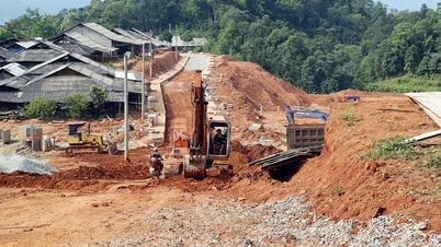
At 1:00 p.m. on October 24, storm Trami moved northwestward and was likely to change direction to west-southwestward at a speed of 15-20 km/h, in the eastern sea of the North East Sea and enter the East Sea.
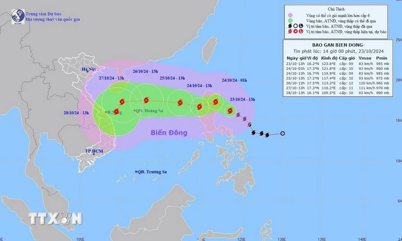
According to the National Center for Hydro-Meteorological Forecasting, storm Trami is likely to change direction to the West Southwest and enter the East Sea.
At 1 p.m. on October 23, storm Trami (Vietnamese name is Tra Mi) was centered at about 16.2 degrees North latitude; 123.6 degrees East longitude, in the sea east of Luzon Island (Philippines). The strongest wind near the storm center was level 9 (75-88 km/h), gusting to level 11; moving in the West Northwest direction, speed 15-20 km/h.
By 1:00 p.m. on October 24, the storm will move northwestward and possibly change direction to west-southwestward at a speed of 15-20 km/h, in the eastern sea of the North East Sea and enter the East Sea. The storm's strongest wind is level 9, gusting to level 11. The affected area is the eastern part of the North East Sea; disaster risk level 3.
As of 1 p.m. on October 25, the storm was moving west-northwest at a speed of 10-15 km/h, in the eastern sea area of the North East Sea, 640 km east of the Hoang Sa area. The strongest wind was level 10, gusting to level 12. The affected area was the eastern part of the North East Sea; disaster risk level 3.
As of 1 p.m. on October 26, the storm was moving westward at a speed of 15-20 km/h, in the sea northeast of the Hoang Sa area. The strongest wind was level 12, gusting to level 15. The affected area was the northern East Sea; disaster risk level 3.
From the next 72-120 hours, the storm will move mainly in a westerly direction, about 15km per hour, then likely change direction to the southwest and move more slowly.
Due to the impact of the storm, the eastern sea area of the North East Sea has strong winds of level 6-7.
From early morning on October 24, the wind increased to level 8 (62-74 km/h), the area near the storm center passed level 9-10 (75-102 km/h), gusting to level 12, waves 3-5m high, the area near the storm center 5-7m, very rough seas.
Vessels operating in the above mentioned dangerous areas are susceptible to the impact of storms, whirlwinds, strong winds and large waves.
Source: VNA/Vietnam+
Source: https://baophutho.vn/ngay-24-10-bao-trami-co-kha-nang-doi-huong-va-di-vao-bien-dong-221377.htm
![[Photo] General Secretary To Lam attends the Vietnam-UK High-Level Economic Conference](https://vphoto.vietnam.vn/thumb/1200x675/vietnam/resource/IMAGE/2025/10/30/1761825773922_anh-1-3371-jpg.webp)
![[Photo] Touching scene of thousands of people saving the embankment from the raging water](https://vphoto.vietnam.vn/thumb/1200x675/vietnam/resource/IMAGE/2025/10/30/1761825173837_ndo_br_ho-de-3-jpg.webp)
![[Photo] The Third Patriotic Emulation Congress of the Central Internal Affairs Commission](https://vphoto.vietnam.vn/thumb/1200x675/vietnam/resource/IMAGE/2025/10/30/1761831176178_dh-thi-dua-yeu-nuoc-5076-2710-jpg.webp)

![[Photo] General Secretary To Lam meets former British Prime Minister Tony Blair](https://vphoto.vietnam.vn/thumb/1200x675/vietnam/resource/IMAGE/2025/10/30/1761821573624_tbt-tl1-jpg.webp)


Comment (0)