
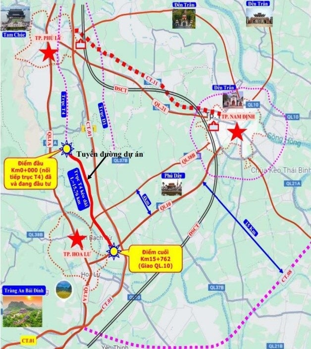
Overview of T4 economic axis project
The Thanh Liem - Cao Bo route construction project (T4 axis) in Ninh Binh is about to be implemented with a total estimated investment of about 2,880 billion VND from the provincial and central budgets. The route is about 16 km long, acting as the backbone of the regional traffic network, connecting economic, political and industrial centers.
The main objective of the project is to complete the T4 economic development axis, connecting the section under construction in Ha Nam with the new administrative center of Ninh Binh province. This investment is considered urgent to reduce the load on the North-South Eastern Expressway (CT.01) and National Highway 1 (QL1) which are currently overloaded, while promoting regional connectivity between the three economic centers of Hoa Lu - Phu Ly - Nam Dinh .
Detailed planning and specifications
Route direction and area of influence
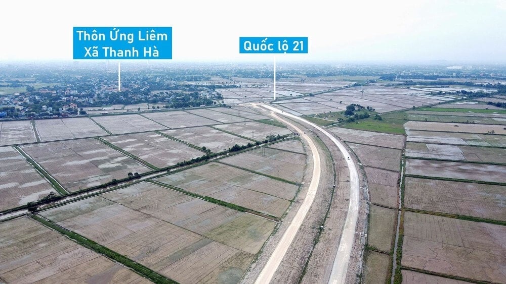
The route starts at Km0+00, connecting to the T4 section under investment in Thanh Liem commune, and ends at Km15+877.70, intersecting with National Highway 10 in Y Yen commune, Ninh Binh province. The project passes through 4 communes: Thanh Liem (0.19 km), Phong Doanh (5.75 km), Tan Minh (3 km) and Y Yen (7.07 km).
To implement the project, it is expected to reclaim about 119 hectares of land, including 4.6 hectares of rural residential land, affecting 202 households and requiring resettlement for 120 households.
Construction scale
The entire route is designed according to class II road standards with the following main parameters:
- Roadbed: 54 m wide.
- Road surface: Includes 2 parallel sections, each 15 m wide (total 30 m).
- Lanes: 6 motor vehicle lanes and 2 mixed vehicle lanes.
- Median strip and trees: 6 m wide (2 x 3 m).
Main works on the route
The project will build 3 overpasses and 5 main intersections:
- KN Canal Overpass: About 86 m long at Km0+190.
- Bo River and Provincial Road 485 Bridge: About 119 m long at Km4+880.
- Bridge over river and National Highway 38B: About 68 m long at Km10+280.
- Intersections: Including intersections with Provincial Road 485, National Highway 38B and other provincial and planned roads.
Project progress
The project is divided into main phases:
- Quarter III/2025 – Quarter IV/2025: Complete design, appraisal, project approval and environmental procedures.
- Quarter I/2026 – Quarter IV/2028: Construction of project items, including site clearance, relocation of technical infrastructure and construction and installation.
- Quarter IV/2028: Expected completion and handover of the project for exploitation and use.
Impact and role in regional planning
Thanh Liem - Cao Bo route (T4) is part of the economic belt axis network of the area. According to the plan, in addition to the T4 axis, this area also has belt routes T1, T2 (DT 495B) and T3 (DT 498) to create a synchronous traffic system, develop urban space according to the chessboard model, effectively connecting industrial parks, urban areas and services.
Source: https://baolamdong.vn/ninh-binh-dau-tu-gan-3000-ty-lam-duong-truc-kinh-te-t4-398003.html
![[Photo] President Luong Cuong attends the 80th Anniversary of the Traditional Day of the Armed Forces of Military Region 3](https://vphoto.vietnam.vn/thumb/1200x675/vietnam/resource/IMAGE/2025/10/28/1761635584312_ndo_br_1-jpg.webp)


![[Photo] Draft documents of the 14th Party Congress reach people at the Commune Cultural Post Offices](https://vphoto.vietnam.vn/thumb/1200x675/vietnam/resource/IMAGE/2025/10/28/1761642182616_du-thao-tai-tinh-hung-yen-4070-5235-jpg.webp)


![[Photo] The 5th Patriotic Emulation Congress of the Central Inspection Commission](https://vphoto.vietnam.vn/thumb/1200x675/vietnam/resource/IMAGE/2025/10/27/1761566862838_ndo_br_1-1858-jpg.webp)


Comment (0)