

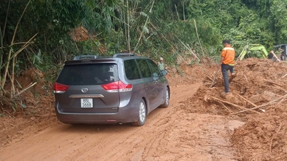
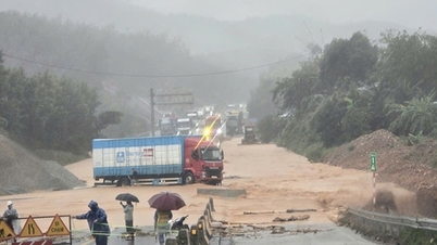
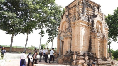
National Highway 1, passing through Luong Son commune, Lam Dong province, was flooded and cut off by rising floodwaters from the Luy River since the early morning of October 28 - Photo: TAN THUAN
Since the early morning of October 28, National Highway 1 through Ong Vac Bridge, Luong Son Commune, Lam Dong Province has been temporarily cut off due to rising floodwaters from the Luy River.
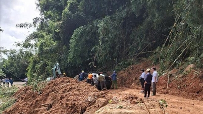
Speaking with Tuoi Tre Online , Mr. Pham Thanh Tuan from the Road Management Office IV.1 said that the unit has arranged staff to coordinate traffic regulation in the flooded area.
According to Mr. Tuan, the current flood water is about half a meter high, stretching about 100 meters, so vehicles cannot pass through this section of National Highway 1 in both directions. Fortunately, National Highway 1 has not had as much traffic as before due to the expressway, so there is only a slight traffic jam.

Lam Dong Provincial Traffic Police Department instructs drivers to turn back onto the highway, avoiding the flooded section on National Highway 1 - Photo: TAN THUAN
In addition, the Traffic Police Department of Lam Dong Province also instructed long-distance drivers to turn around and go onto the Vinh Hao - Phan Thiet Expressway to change their route.
Lam Dong Province Hydrometeorological Station previously forecasted that from the evening of October 27 to the morning of October 28, the rain situation in the basin would increase, and floods on the Luy River were likely to rise again. The flood peak could reach approximately level II alarm (27.5 m).
Localities also warn of the risk of landslides on slopes, embankments, and flooding in low-lying areas along upstream rivers and streams in the Luy River basin.

The rising water level of the Luy River caused flooding in the National Highway 1 area, passing through Luong Son commune, Lam Dong province - Photo: TAN THUAN
According to the plan of Binh Thuan Irrigation Works Exploitation Company Limited, at 3:00 p.m. on October 27, the unit increased the amount of water regulated through the spillway of Luy River from 200 - 350m3 /s.
In addition, due to heavy rain, the water level of Nui Dat Lake is currently at +23.73m, 0.23m higher than the normal water level and is continuing to rise. Some local reservoirs are also planning to release overflows due to reaching the level.
Source: https://tuoitre.vn/nuoc-lu-song-luy-dang-cao-chia-cat-quoc-lo-1-o-lam-dong-2025102807384841.htm


![[Photo] President Luong Cuong attends the 80th Anniversary of the Traditional Day of the Armed Forces of Military Region 3](https://vphoto.vietnam.vn/thumb/1200x675/vietnam/resource/IMAGE/2025/10/28/1761635584312_ndo_br_1-jpg.webp)


![[Photo] Party Committees of Central Party agencies summarize the implementation of Resolution No. 18-NQ/TW and the direction of the Party Congress](https://vphoto.vietnam.vn/thumb/1200x675/vietnam/resource/IMAGE/2025/10/27/1761545645968_ndo_br_1-jpg.webp)
![[Photo] The 5th Patriotic Emulation Congress of the Central Inspection Commission](https://vphoto.vietnam.vn/thumb/1200x675/vietnam/resource/IMAGE/2025/10/27/1761566862838_ndo_br_1-1858-jpg.webp)
![[Photo] National Assembly Chairman Tran Thanh Man receives Chairman of the House of Representatives of Uzbekistan Nuriddin Ismoilov](https://vphoto.vietnam.vn/thumb/1200x675/vietnam/resource/IMAGE/2025/10/27/1761542647910_bnd-2610-jpg.webp)


Comment (0)