
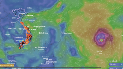
According to the National Center for Hydro-Meteorological Forecasting, with a stable direction of movement in the West-Northwest direction and fast speed, storm No. 13 is forecast to make landfall in our country very soon, around the night of November 6 to the morning of November 7.
In terms of intensity, after entering the East Sea, the storm continued to strengthen. At 7:00 a.m. on November 5, while operating in the central East Sea, the storm was at level 13, gusting to level 16. During the day and night of November 5, the storm continued to strengthen. At 7:00 a.m. on November 6, while operating in the central East Sea, off the coast of Gia Lai province (formerly Binh Dinh), the storm strengthened to level 14, gusting to level 17.
It is forecasted that during the day and night of November 6, the storm will gradually move towards the sea area from Quang Ngai to Dak Lak (formerly Phu Yen ) with a slight decrease in intensity, then enter our mainland with a strong intensity of level 11 - 12, gusting to level 14 - 15. At 7:00 a.m. on November 7, when entering deep into the mainland area from Quang Ngai to Dak Lak, the storm will still maintain an intensity of level 10 - 11, gusting to level 13.
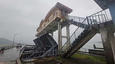
Due to the strong intensity of the storm, the area of influence is forecast to be very large, the area of strong winds may extend from Da Nang to Khanh Hoa. Meanwhile, the area of heavy rain may extend from Quang Tri to Dak Lak, lasting from the night of November 6 to November 9. In addition, the meteorological agency is paying special attention to the possibility of tornado-like conditions before the storm arrives.
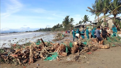
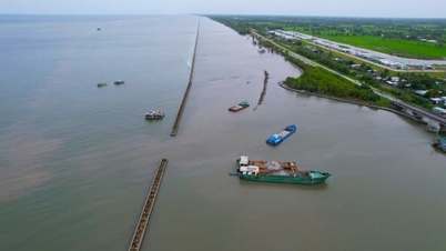
. Photo: Tung Dinh.")
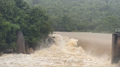
Overcoming the consequences of typhoon Yagi in 2024 in Hai Duong (old). Photo: Tung Dinh.
Faced with that situation, to proactively respond, the Department of Crop Production and Plant Protection requested the Department of Agriculture and Environment of the provinces to direct a number of contents.
Firstly, proactively drain buffer water on the main river system and intra-field canals, drain riverbeds, and keep fields shallow; mobilize forces to clear the flow on drainage canals, check and raise the banks of areas, plot banks, and drainage canal banks to ensure quick drainage for areas at risk of flooding.
Second, direct relevant agencies and commune-level authorities on a number of measures to prevent storms and restore production after storm No. 13. Specifically, for rice, localities with unharvested rice areas need to direct and urge harvesting before November 7, 2025 according to the motto "green house is better than old field". Mobilize maximum electric and gasoline pumps to be ready for forced pumping combined with quick drainage when the tide goes down to reduce flooding.
For vegetable growing areas, organize timely harvesting of areas that are ready for harvest to limit damage caused by storms and rains, and proactively dredge and clear ditches and drainage ditches in newly planted vegetable fields that are not yet ready for harvest. Plant short-term vegetable varieties to meet the increased demand for green vegetables after storms.
For fruit trees, it is recommended to focus on harvesting early in areas that are ready for harvest. For fruit-bearing trees that are not yet ready for harvest, it is necessary to proactively prune off some of the fruit on the bunch to avoid collisions that cause damage or fruit drop.
In addition, it is possible to use sturdy 3-way support stakes and nylon ropes to support and minimize damage caused by falling trees, broken branches, and fallen fruits; prune (fruits, overgrown branches, and intertwined branches) to create ventilation for the tree; drain water to avoid waterlogging. At the same time, dig ditches and drainage channels to avoid localized flooding in the garden.
As for banana trees, the Department recommends pruning all the yellowed leaves, and using a pole to hit the green leaves across the leaf midrib to reduce the area that blocks storm winds. Use specialized pineapple rope to tie the lower part of the leaf collar, tie the trees together in a square like a chessboard to form a solid block.
In addition, use diagonal stakes to support the banana tree trunk at the leaf collar (plants that have not yet produced bunches), bunch collar (plants that already have bunches), each tree from 1 to 2 stakes depending on the actual situation and bunch size.
For industrial trees, it is necessary to tie the tree trunk or large branches in 3 directions to limit falling (note that you should use inner tubes or tires to wrap around before tying the rope to avoid damaging the tree bark or branches; open the wire right after a storm), and you can prune to keep the garden airy. In addition, it is necessary to cut drainage ditches to increase drainage, avoiding local flooding in rubber and pepper gardens.
The Department also requested the Department of Agriculture and Environment of localities in the affected areas of storm No. 13 to urgently review the damaged rice, crops and other plants. Strengthen the work of predicting and forecasting the occurrence of harmful organisms that cause damage to plants in order to have timely and effective prevention measures to minimize the impact of pests and diseases after the storm passes.
Along with that, propose mechanisms and policies to support people in damaged areas to restore production. Direct and guide farmers to quickly replant damaged vegetable areas to ensure people's income.
Source: https://nongnghiepmoitruong.vn/thu-hach-nhanh-lua-rau-mau-cay-an-qua-truoc-bao-kalmaegi-d782758.html


![[Photo] Da Nang: Hundreds of people join hands to clean up a vital tourist route after storm No. 13](https://vphoto.vietnam.vn/thumb/1200x675/vietnam/resource/IMAGE/2025/11/07/1762491638903_image-3-1353-jpg.webp)


Comment (0)