
The center of storm Tra Mi (storm number 6) is on the eastern sea of the North East Sea, level 9-10, gust level 12, moving at about 10km/h.
According to the National Center for Hydro-Meteorological Forecasting, at 4:00 a.m. on October 25, the center of storm Tra Mi (storm No. 6) was at about 17.0 degrees North latitude; 119.0 degrees East longitude, in the eastern sea of the North East Sea. The strongest wind near the center of the storm was level 9-10 (75-102 km/h), gusting to level 12. Moving westward, at a speed of about 10 km/h.
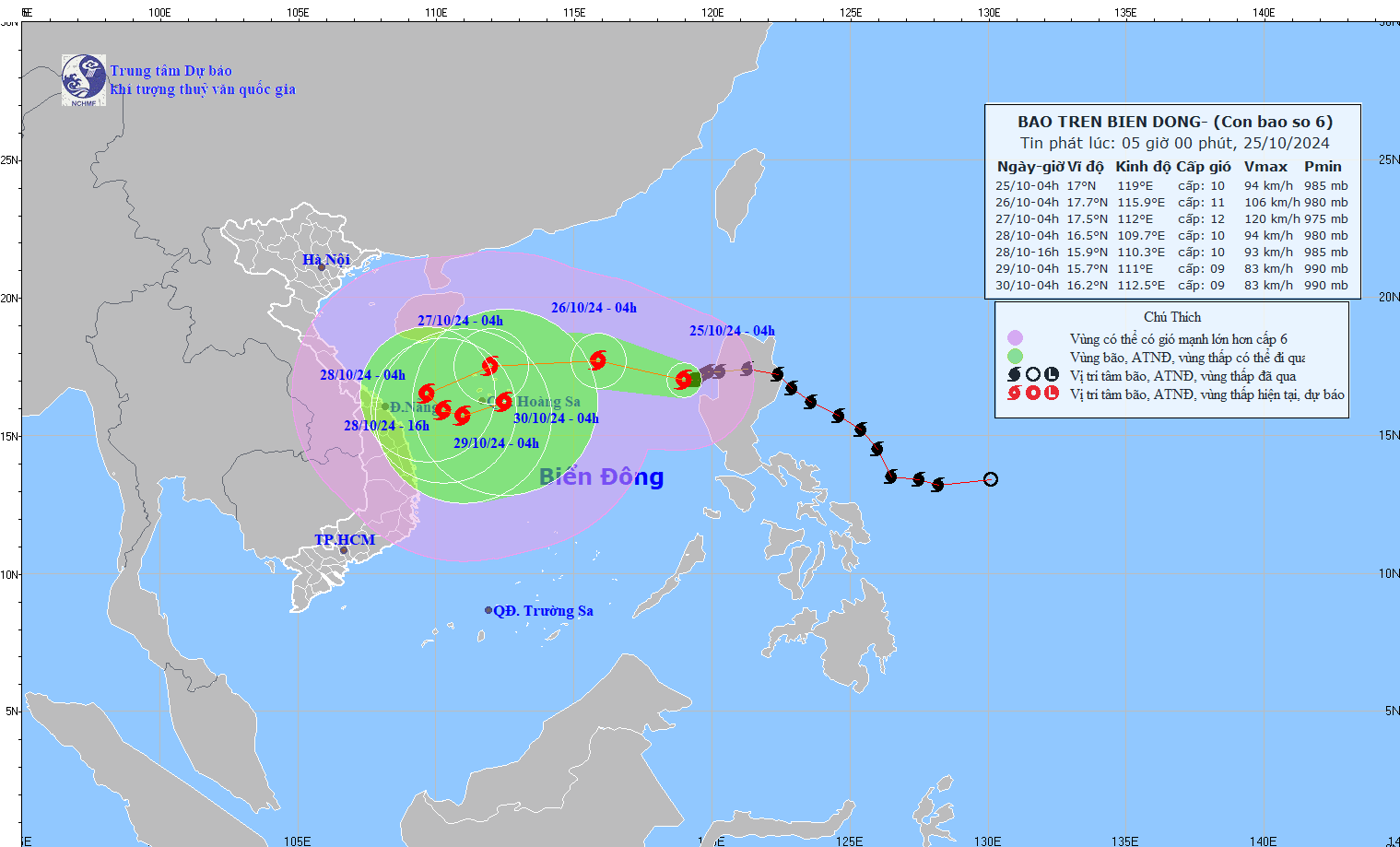
The meteorological agency forecasts that in the next 24 to 72 hours, storm Tra Mi will intensify and change direction, specifically as follows:
| Forecast time | Direction, speed | Location | Intensity | Danger zone | Disaster Risk Level (Affected Area) |
|---|---|---|---|---|---|
| 04h/26/10 | West Northwest, 10-15km/h | 17.7N-115.9E; in the eastern sea of the North East Sea; about 490km east of Hoang Sa archipelago | Level 10-11, level 13 jerk | Latitude 15.0N-19.5N; East of longitude 113.5E | Level 3: East of the North East Sea area |
| 04h/27/10 | West, 15-20km/h | 17.5N-112.0E; in the area north of Hoang Sa archipelago | Level 11-12, level 14 jerk | Latitude 15.0N-20.5N; East of longitude 109.0E | Level 3: North East Sea area (including Hoang Sa archipelago area) |
| 04h/28/10 | West Southwest, 10-15km/h | 16.5N-109.7E; on the western sea of the North East Sea; about 230km west of Hoang Sa archipelago | Level 10, level 12 | Latitude 14.0N-19.5N; West of longitude 113.0E | Level 3: Western area of the North East Sea (including the Paracel Islands area) |
Storm No. 6 causes strong winds and large waves at sea. The sea area to the east of the North East Sea has strong winds at level 7, then increasing to level 8, near the storm center it has levels 9-10 (75-102km/h), gusts at level 12, waves 5-7m high, near the storm center 7-9m; very rough seas.
Vessels operating in the above mentioned dangerous areas are susceptible to the impact of storms, whirlwinds, strong winds and large waves.
Source: https://vietnamnet.vn/tin-bao-tra-mi-bao-so-6-moi-nhat-ngay-25-10-giat-cap-12-huong-di-phuc-tap-2335322.html
![[Photo] Prime Minister Pham Minh Chinh chaired a meeting to discuss solutions to overcome the consequences of floods in the central provinces.](https://vphoto.vietnam.vn/thumb/1200x675/vietnam/resource/IMAGE/2025/10/29/1761716305524_dsc-7735-jpg.webp)

![[Photo] Flooding on the right side of the gate, entrance to Hue Citadel](https://vphoto.vietnam.vn/thumb/1200x675/vietnam/resource/IMAGE/2025/10/28/1761660788143_ndo_br_gen-h-z7165069467254-74c71c36d0cb396744b678cec80552f0-2-jpg.webp)

![[Photo] Hue: Inside the kitchen that donates thousands of meals a day to people in flooded areas](https://vphoto.vietnam.vn/thumb/1200x675/vietnam/resource/IMAGE/2025/10/29/1761738508516_bepcomhue-jpg.webp)


![[Infographic] Vietnam's socio-economic situation in 5 years 2021-2025: Impressive numbers](https://vphoto.vietnam.vn/thumb/402x226/vietnam/resource/IMAGE/2025/10/29/1761730747150_anh-man-hinh-2025-10-29-luc-16-38-55.png)


![[Live] Concert Ha Long 2025: "Heritage Spirit - Brightening the Future"](https://vphoto.vietnam.vn/thumb/402x226/vietnam/resource/IMAGE/2025/10/29/1761743605124_g-anh-sang-am-thanh-hoanh-trang-cua-chuong-trinh-mang-den-trai-nghiem-dang-nho-cho-du-khach-22450328-17617424836781829598445-93-0-733-1024-crop-1761742492749383512980.jpeg)


Comment (0)