
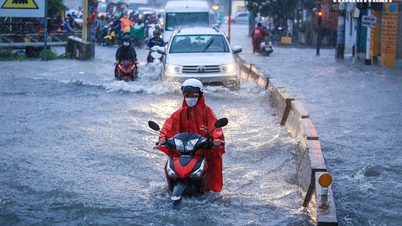
On the afternoon of October 1st, heavy rain fell across a wide area of Southern Vietnam. Particularly in Ho Chi Minh City, the heavy rain combined with high tides caused flooding on many roads, significantly impacting traffic and the daily lives of residents.

Heavy, widespread rain is expected to continue for the next few days.
According to the National Center for Hydro-Meteorological Forecasting: Last night and this morning (October 2nd), the area from Da Nang to Binh Thuan, the Central Highlands, and the Southern region experienced showers and thunderstorms, with localized heavy to very heavy rain. Rainfall amounts from 7 PM on October 1st to 8 AM on October 2nd exceeded 60mm in some areas, such as: An Hung (Binh Dinh) 61.7mm, Phan Thiet City (Binh Thuan) 98.8mm, Kien Binh (Long An) 75.6mm, My Phuoc ( Tien Giang ) 67.6mm, Vien An (Soc Trang) 66.8mm, An Ninh (Kien Giang) 71.2mm...
Widespread thunderstorms are forecast for South Central Vietnam, the Central Highlands, and Southern Vietnam.
A rainfall of 50mm is considered heavy rain. Based on this criterion, the Southern Regional Hydrometeorological Station added several other locations with heavy rainfall, such as: Tuc Truong (Dong Nai) 57.8mm, Nha Be (Ho Chi Minh City) 54.6mm, Thoi Binh ( Ca Mau ) 54.2mm, and Nui Ba (Tay Ninh) 53.4mm.
Experts predict that heavy rain will continue in the area from Da Nang to Binh Thuan , across the southern provinces and the Central Highlands, lasting at least until the end of October 3rd, with predicted rainfall amounts ranging from 40 to 100mm.
During thunderstorms, there is a possibility of tornadoes, lightning, and strong gusts of wind. Localized heavy rainfall may cause flooding in low-lying areas and pose a risk of flash floods and landslides in mountainous regions.
The current heavy rainfall is due to the influence of a storm east of the Philippines that formed on the afternoon of September 30th. This storm, internationally named Koinu and locally named Jenny, has intensified the southwest monsoon, causing heavy rain in the southern and Central Highlands provinces. Experts also believe there is a possibility that this storm could enter the South China Sea. Therefore, bad weather will continue for the next few days, especially in the coastal areas from Binh Thuan to Ca Mau, Ca Mau to Kien Giang, the Gulf of Thailand, and the southern South China Sea (including the waters around the Spratly Islands), where strong showers and thunderstorms are occurring.
Source link


![[Photo] Two flights successfully landed and took off at Long Thanh Airport.](/_next/image?url=https%3A%2F%2Fvphoto.vietnam.vn%2Fthumb%2F1200x675%2Fvietnam%2Fresource%2FIMAGE%2F2025%2F12%2F15%2F1765808718882_ndo_br_img-8897-resize-5807-jpg.webp&w=3840&q=75)


Comment (0)