
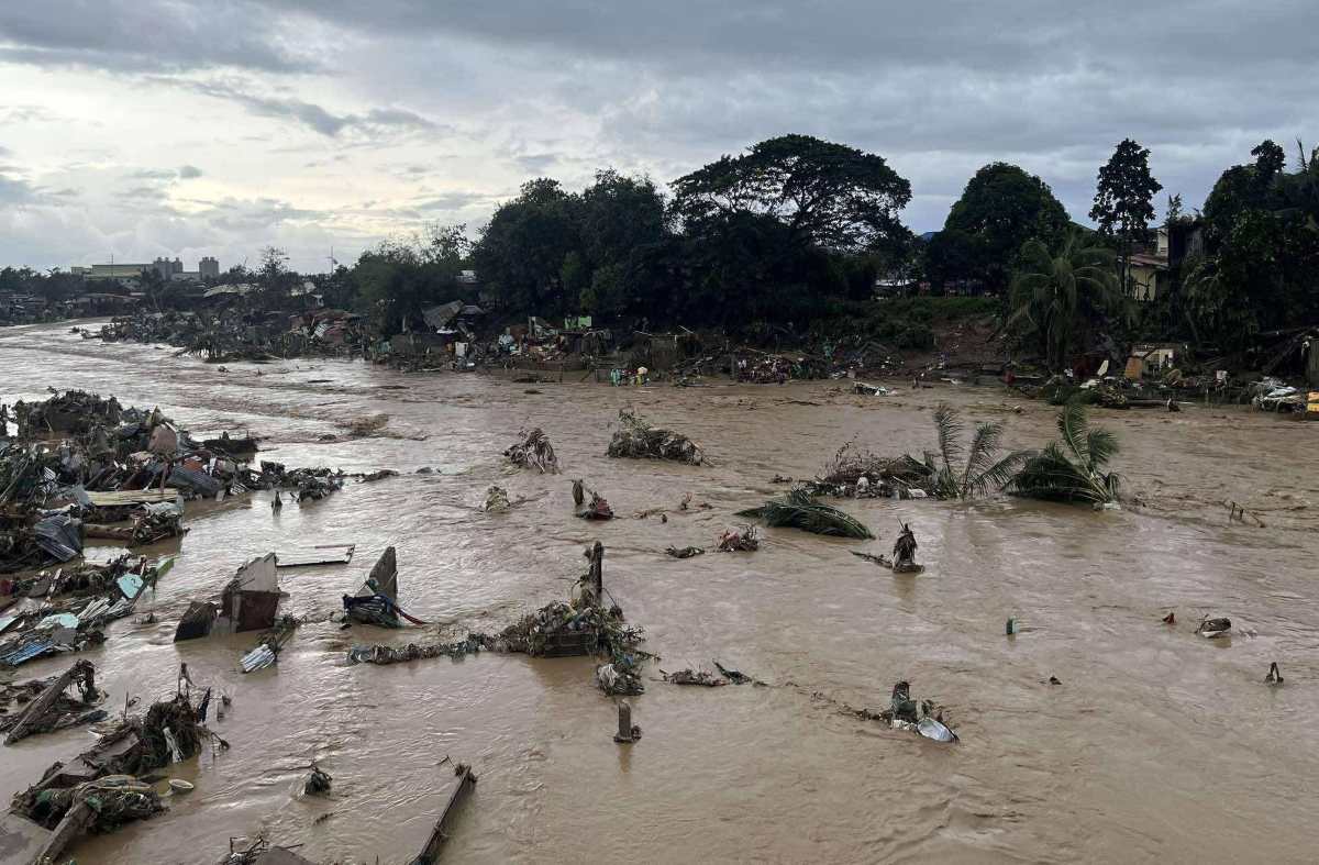
Floods after Typhoon No. 13 Kalmaegi (Tino) destroyed many houses in Talisay City, Cebu Province, Philippines on November 4. Photo: Philippine Weather System/Pacific Storm Update
The Philippines is reeling from the devastating effects of Typhoon No. 13 Kalmaegi (local name Tino) with torrential rains and widespread flash floods.
At least 46 people have died in floods in the central region of the country, hundreds of houses have been swept away or submerged in muddy water, and many key roads have been cut off.
Data from the Japan Aerospace Exploration Agency (JAXA) shows that rainfall in the central Philippines in the past three days has exceeded 610mm - equivalent to the average rainfall for the entire month of November. Strong winds, high waves and high tides have completely isolated many coastal areas.
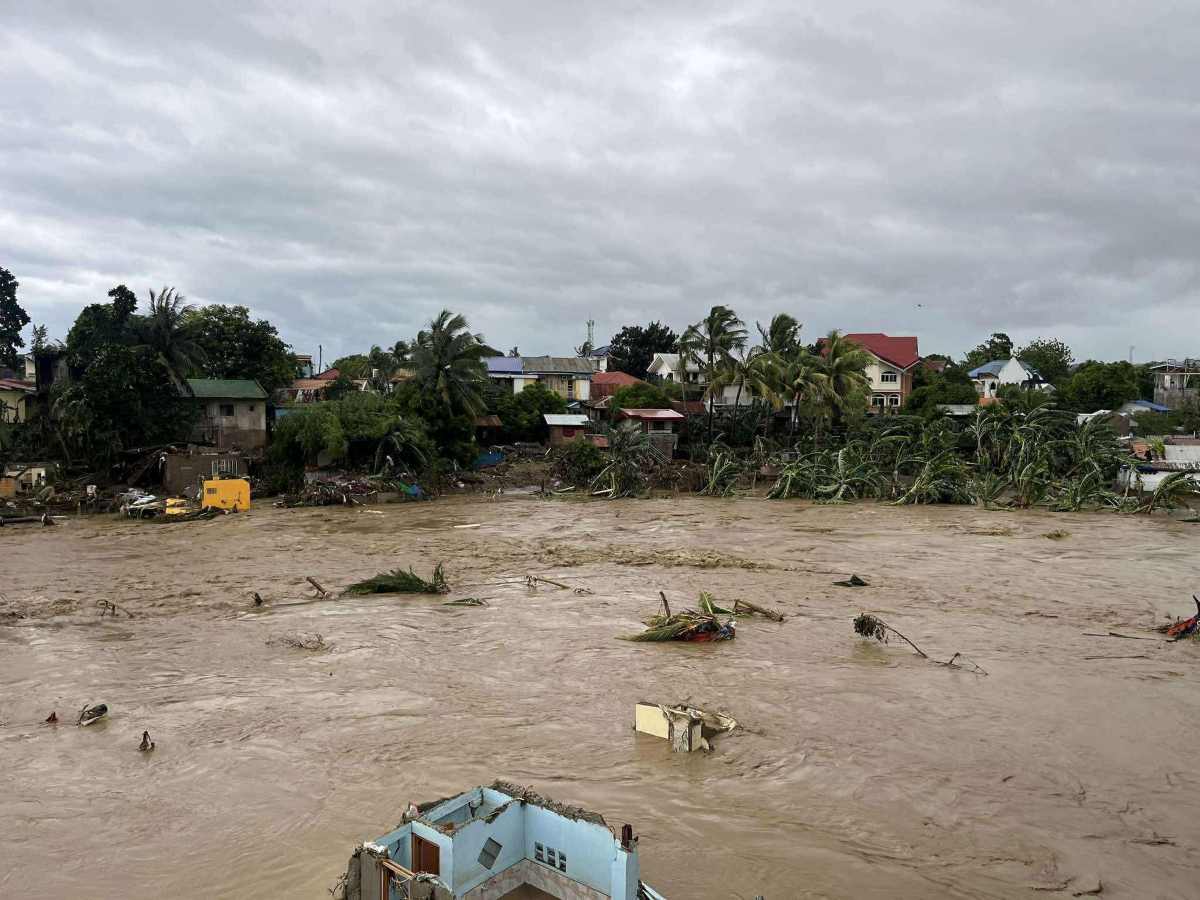
Floods after Typhoon No. 13 devastated Barangay San Isidro, Talisay, Cebu province. Photo: Philippine Weather System/Pacific Storm Update
While the Philippines continues to recover, meteorologists warn that another storm is brewing in the eastern Pacific . A tropical depression that passed south of Guam is expected to intensify into Typhoon Fung-wong (Uwan) by mid-week.
The new storm is expected to move west-northwest, possibly reaching strong intensity before approaching the northern Philippines or Taiwan (China) early next week.
Natural disasters have struck the Southeast Asian island nation in succession just weeks after a 7.4 magnitude earthquake rocked the southern Philippines.
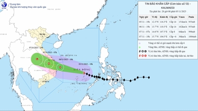
Meanwhile, according to the latest storm news from the Vietnam National Center for Hydro-Meteorological Forecasting, early this morning (November 5), storm Kalmaegi entered the eastern sea area of the central East Sea, becoming the 13th storm in the East Sea in 2025.
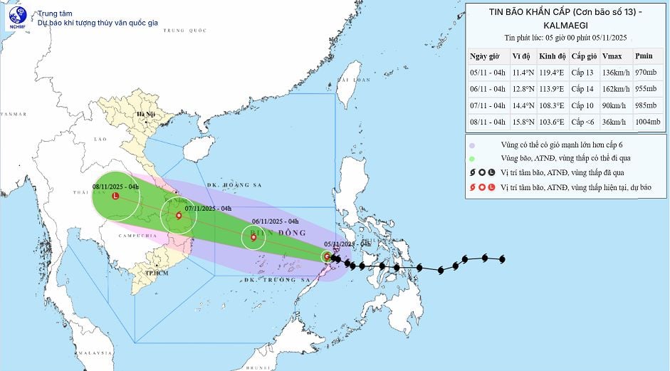
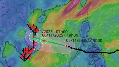
Forecast of the path and landing zone of storm No. 13 in Vietnam. Photo: Vietnam National Center for Hydro-Meteorological Forecasting
At 6:00 a.m. on November 5, the center of the storm was at approximately 11.4 degrees north latitude; 119.0 degrees east longitude, approximately 510 km east of Song Tu Tay Island. The strongest wind was level 13 (134-149 km/h), gusting to level 16. It is forecasted that in the next 3 hours, the storm will move west-northwest at a speed of approximately 20-25 km/h.
Forecast as of 4am on November 6, the eye of the storm is at 12.8 degrees north latitude, 113.9 degrees east longitude; about 550km east southeast of the coast of Gia Lai province. The storm is likely to strengthen, reaching level 14, gusting to level 17, moving west-northwest at about 25km/h.
Forecast until 4am on November 7, the center of the storm is at 14.4 degrees north latitude, 108.3 degrees east longitude, on the mainland from Quang Ngai to Dak Lak . The storm is gradually weakening, level 9-10, gusting to level 12, moving west-northwest, about 25 km/h.
The eye of storm No. 13 is forecast to move into the northern Phu Yen and southern Quang Ngai areas, but that may change. The eye of the storm is forecast to make landfall around the evening of November 6 and the morning of November 7. However, the rain center is ahead of the storm, so heavy rain will occur from noon on November 6.
Rain forecast from November 6-7: The area from Da Nang City to Dak Lak will have very heavy rain with common rainfall of 200-400 mm/period, locally over 600 mm/period; the area from southern Quang Tri to Hue City, Khanh Hoa and Lam Dong will have heavy rain with common rainfall of 150-300 mm/period, locally over 450 mm/period. From November 8, heavy rain in the above areas will tend to decrease.
From November 7-8, the area from northern Quang Tri to Thanh Hoa will have moderate to heavy rain with common rainfall of 50-150 mm/period, locally very heavy rain of over 200 mm/period. Warning of risk of heavy rain (>200 mm/3 hours).
According to Lao Dong Newspaper
Source: https://baotuyenquang.com.vn/xa-hoi/202511/bao-so-13-kalmaegi-tan-pha-philippines-du-bao-tam-do-bo-viet-nam-21703eb/


![[Photo] Opening of the 14th Conference of the 13th Party Central Committee](https://vphoto.vietnam.vn/thumb/1200x675/vietnam/resource/IMAGE/2025/11/05/1762310995216_a5-bnd-5742-5255-jpg.webp)


![[Photo] Panorama of the Patriotic Emulation Congress of Nhan Dan Newspaper for the period 2025-2030](https://vphoto.vietnam.vn/thumb/1200x675/vietnam/resource/IMAGE/2025/11/04/1762252775462_ndo_br_dhthiduayeuncbaond-6125-jpg.webp)


Comment (0)