
During the day and night of September 9, the Central Highlands and the South will have showers and thunderstorms, with some places experiencing heavy rain with rainfall of 15-30mm, and some places experiencing over 80mm (rain concentrated in the afternoon and evening).

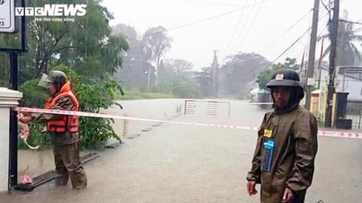
According to the National Center for Hydro-Meteorological Forecasting, on the day and night of September 9, dangerous weather patterns will continue to occur on land and at sea.
The National Center for Hydro-Meteorological Forecasting informed that in the coming hours, the tropical depression will continue to move in the West-Northwest direction at a speed of 15-20 km/h, gradually weakening into a low pressure area over the mainland of Guangxi province (China) and will no longer be able to directly affect Vietnam. This is the last news about storm No. 7.
At 10:00 p.m. on September 8, the center of the tropical depression (weakened from storm No. 7) was at about 23.5 degrees North latitude; 110.6 degrees East longitude, on the mainland of Guangxi province (China).
The strongest wind near the center of the tropical depression is level 6 (39-49 km/h), gusting to level 8. Moving in the West Northwest direction, speed 15-20 km/h.
Northern mountainous and midland areas have localized rain over 300mm
The National Center for Hydro-Meteorological Forecasting said that from the morning of September 9 to the night of September 10, the mountainous and midland areas of the North will have moderate rain, heavy rain and scattered thunderstorms, some places will have very heavy rain with common rainfall of 70-150mm, some places will have over 300mm. Warning of the risk of heavy rain over 100mm/3 hours.
From September 11, heavy rain in mountainous and midland areas of the North gradually decreased.
"Total rainfall from the morning of September 9 to the end of the night of September 10, in the mountainous and midland areas of the North, is generally 70-150mm, locally over 300mm. Warning level 1 of natural disaster risk due to heavy rain, tornadoes, lightning, and hail," noted Deputy Head of the Weather Forecasting Department Vu An Tuan.
During the day and night of September 9, the Central Highlands and the South will have showers and thunderstorms, with some places experiencing heavy rain with rainfall of 15-30mm, and some places experiencing over 80mm (rain concentrated in the afternoon and evening).
Warning of risk of heavy rain over 60 mm/3 hours, thunderstorms with possibility of tornadoes, lightning, hail and strong gusts of wind.

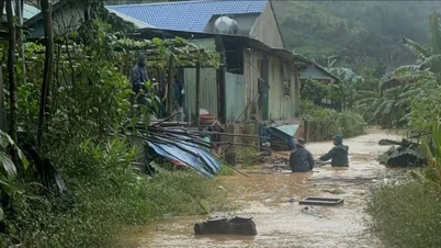
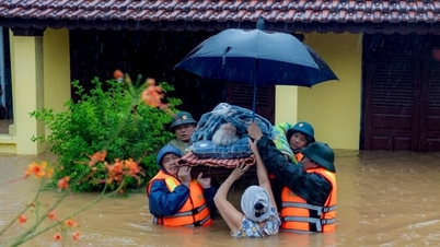
Heavy rains are likely to cause flooding in low-lying areas, urban and industrial areas; flash floods on small rivers and streams, landslides on steep slopes (real-time warning information on areas at risk of flash floods and landslides is provided online on the website of the Department of Hydrometeorology at: https://luquetsatlo.nchmf.gov.vn and in separate bulletins warning of flash floods and landslides).
On the night of September 8 and early morning of September 9, the mountainous and midland areas of the North will have rain, moderate rain and scattered thunderstorms, locally heavy to very heavy rain with rainfall from 7:00 p.m. on September 8 to 3:00 a.m. on September 9, some places will have over 80mm such as Thanh Tin station (Tuyen Quang) 100.2mm, Thach An station ( Cao Bang ) 97.4mm, Ha Long station (Quang Ninh) 87mm, Tan Minh station (Lang Son) 83.5mm...
Beware of flash floods and landslides in 6 northern mountainous provinces
According to the National Center for Hydro-Meteorological Forecasting, from 5:40 a.m. to 10:40 a.m., the above provinces will continue to have rain with common accumulated rainfall as follows: Lai Chau , Son La from 10-30mm, some places over 80mm; Tuyen Quang, Cao Bang, Thai Nguyen and Lang Son from 30-60mm, some places over 100mm.
Risk warning: flash floods on small rivers and streams, landslides on steep slopes in many communes/wards: Khoen On, Le Loi, Muong Kim, Muong Than, Nam Cuoi, Nam So, Tan Uyen, Than Uyen, Tua Sin Chai (Lai Chau province); Muong Chien, Muong Gion (Son La province); Thang Tin, Tung Ba; Bac Me, Bac Quang, Ban May, Cao Bo, Con Lon, Dong Tam, Du Gia, Duong Hong, Giap Trung, Ho Thau, Hoang Su Phi, Hong Thai, Kien Dai, Lam Binh, Lao Chai, Linh Ho, Mau Due, Minh Ngoc, Nam Dich, Ngoc Duong, Ngoc Long, Phu Linh, Tan Quang, Tan Tien, Tan Trinh, Thanh Thuy, Thong Nguyen, Thuan Hoa, Thuong Lam, Thuong Nong, Tien Nguyen, Vi Xuyen, Viet Lam, Xin Man, Yen Cuong, Yen Hoa (Tuyen Quang province).
Along with that are the communes and wards: Bang Van, Cuong Loi, Na Phac, Na Ri, Ngan Son, Phuc Loc, Thuong Minh, Tran Phu, Van Lang; Ba Be, Bang Thanh, Cam Giang, Cao Minh, Cho Ra, Con Minh, Dong Phuc, Hiep Luc, Nghien Loan, Phu Thong, Thuong Quan, Vinh Thong (Thai Nguyen province); Bach Dang, Canh Tan, Dong Khe, Nguyen Hue, Tam Kim, Thanh Cong; Bao Lac, Bao Lam, Be Van Dan, Ca Thanh, Co Ba, Coc Pang, Duc Long, Hanh Phuc, Hoa An, Hung Dao, Kim Dong, Ly Bon, Minh Khai, Minh Tam, Nam Quang, Nam Tuan, Nguyen Binh, Nung Tri Cao, Tan Giang, Thuc Phan, Phuc Hoa, Quang Han, Quang Lam, Quang Uyen, Son Lo, Thach An, Tra Linh, Yen Tho (Cao Bang province); Doan Ket, Hoang Van Thu, Khang Chien, Na Sam, Thuy Hung, Van Lang; Ba Son, Bac Son, Binh Gia, Cao Loc, Cong Son, Diem He, Dong Dang, Hoa Tham, Hoi Hoan, Hong Phong, Khanh Khe, Dong Kinh Ward, Ky Lua Ward, Luong Van Tri Ward, Quoc Khanh, Quoc Viet, Quy Hoa, Tan Tien, Tan Tri, Tan Van, That Khe, Thien Hoa, Thien Long, Thien Thuat, Trang Dinh, Van Quan (Lang Son province).

Flash floods and landslides can have very negative impacts on the environment, threaten people's lives; cause local traffic congestion, affect the movement of vehicles; destroy civil and economic works, causing damage to production and socio-economic activities.
The Hydrometeorological Agency recommends that local authorities pay attention to reviewing bottlenecks and vulnerable locations in the area to have prevention and response measures.
From 0-4 a.m. on September 9, the provinces of Lai Chau, Son La, Tuyen Quang, Cao Bang, Thai Nguyen and Lang Son had moderate to heavy rain such as Trung Dong 2 (Lai Chau) 69mm; Chieng Khay (Son La) 50.4mm; Thanh Tin (Tuyen Quang) 101mm; An Lai (Cao Bang) 115.2mm; Bang Van (Thai Nguyen) 61.2mm; Tan Minh (Lang Son) 91.3mm...
Soil moisture models show that some areas in the above provinces are close to saturation (over 85%) or have reached saturation.
Many sea areas have strong gusts of wind and high waves.
The National Center for Hydro-Meteorological Forecasting predicts that there will be showers and thunderstorms in the western sea area of the North East Sea (including Hoang Sa special zone), Ca Mau to An Giang and the Gulf of Thailand.
It is forecasted that on the day and night of September 9, the Gulf of Tonkin, the sea area from Lam Dong-Ca Mau, Ca Mau-An Giang, the Gulf of Thailand, the western sea area of the North East Sea (including Hoang Sa special zone) and the South East Sea (including Truong Sa special zone) will have scattered showers and thunderstorms. During thunderstorms, there is a possibility of tornadoes, strong gusts of wind of level 6-7 and waves over 2m high.
All vessels operating in the above areas are at risk of being affected by tornadoes and strong gusts of wind.
Weather in regions day and night 9/9
Northwest
- During the day there will be rain, moderate rain and scattered thunderstorms. In the afternoon and at night there will be moderate rain, heavy rain and scattered thunderstorms. In some places there will be very heavy rain. During thunderstorms there is a possibility of tornadoes, lightning and strong gusts of wind.
- Lowest temperature 23-26 degrees Celsius, some places below 22 degrees Celsius. Highest temperature 30-33 degrees Celsius.
Northeast
- Mountainous and midland areas have moderate rain, heavy rain and scattered thunderstorms, locally very heavy rain in some places; other areas have scattered showers and thunderstorms in the day, scattered showers and thunderstorms in the afternoon and at night, locally heavy rain in some places, with the possibility of tornadoes, lightning and strong gusts of wind in thunderstorms.
- Lowest temperature 25-27 degrees Celsius, in mountainous and midland areas 23-25 degrees Celsius, some places below 22 degrees Celsius. Highest temperature 31-33 degrees Celsius, some places above 33 degrees Celsius, in mountainous and midland areas 28-31 degrees Celsius.
Hanoi City
- During the day there will be scattered showers and thunderstorms, in the afternoon and at night there will be scattered showers and thunderstorms, with heavy rain in some places.
- Lowest temperature 25-27 degrees Celsius. Highest temperature 31-33 degrees Celsius, some places above 33 degrees Celsius.
Provinces and cities from Thanh Hoa to Hue
- Sunny day, hot in some places; showers and thunderstorms in some places in the evening and at night, with the possibility of tornadoes, lightning and strong gusts of wind. Southwest wind level 2-3.
- Lowest temperature 25-28 degrees Celsius. Highest temperature 32-35 degrees Celsius, some places above 35 degrees Celsius.
South Central Coast
- Sunny day, scattered showers and thunderstorms in the late afternoon and evening, scattered showers and thunderstorms at night, with the possibility of tornadoes, lightning and strong gusts of wind during thunderstorms. Southwest wind level 2-3.
- Lowest temperature 24-27 degrees Celsius. Highest temperature 31-34 degrees Celsius, some places above 34 degrees Celsius.
Central Highlands
- There will be scattered showers and thunderstorms in some places; in the afternoon and evening there will be scattered showers and thunderstorms, locally heavy rain in some places, with the possibility of tornadoes, lightning and strong gusts of wind. Southwest wind level 2-3.
- Lowest temperature 20-23 degrees Celsius. Highest temperature 27-30 degrees Celsius, some places above 30 degrees Celsius.
Southern region
- There will be showers and thunderstorms in some places, especially in the afternoon and evening, with scattered showers and thunderstorms, locally heavy rain, with the possibility of tornadoes, lightning and strong gusts of wind in thunderstorms. Southwest wind level 2-3.
- Lowest temperature 23-26 degrees Celsius. Highest temperature 30-33 degrees Celsius.
Ho Chi Minh City
- There will be showers and thunderstorms in some places, especially in the afternoon and evening, with scattered showers and thunderstorms, locally heavy rain, with the possibility of tornadoes, lightning and strong gusts of wind in thunderstorms. Southwest wind level 2-3.
- Lowest temperature 24-26 degrees Celsius. Highest temperature 30-33 degrees Celsius./.
Source: https://baolangson.vn/hoan-luu-bao-gay-mua-lon-o-vung-nui-va-trung-du-bac-bo-5058343.html
![[Photo] The 5th Patriotic Emulation Congress of the Central Inspection Commission](https://vphoto.vietnam.vn/thumb/1200x675/vietnam/resource/IMAGE/2025/10/27/1761566862838_ndo_br_1-1858-jpg.webp)


![[Photo] Party Committees of Central Party agencies summarize the implementation of Resolution No. 18-NQ/TW and the direction of the Party Congress](https://vphoto.vietnam.vn/thumb/1200x675/vietnam/resource/IMAGE/2025/10/27/1761545645968_ndo_br_1-jpg.webp)
![[Photo] National Assembly Chairman Tran Thanh Man receives Chairman of the House of Representatives of Uzbekistan Nuriddin Ismoilov](https://vphoto.vietnam.vn/thumb/1200x675/vietnam/resource/IMAGE/2025/10/27/1761542647910_bnd-2610-jpg.webp)


Comment (0)