

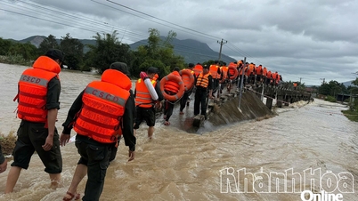
Border guards evacuate people in Thanh Phat residential group (Nam Nha Trang ward) - Photo: VAN TAN
On the morning of November 17, Khanh Hoa Hydrometeorological Station recorded that in the past 12 hours, flood water levels on Cai Nha Trang River increased very rapidly.
At 8:00 a.m. on November 17, the water level at Dong Trang station was measured at 9.71m, exceeding alarm level 2 by 0.21m; Dien Phu station was 5.6m, exceeding alarm level 3 by 0.1m.
At Cai Phan Rang River, the flood is also rising strongly. The water level at Tan My station reached 38.27m, 0.77m higher than alarm level 3; at Phan Rang station it was 3.21m, 0.29m higher than alarm level 1.
It is forecasted that in the next 24 hours, the flood on Cai Nha Trang River will continue to rise and peak in the next 7-12 hours. The flood peak at Dong Trang is likely to be close to alert level 3, while at Dien Phu it may exceed alert level 3 by 0.5-1m.
Other rivers and streams in the province are also likely to experience floods at alert levels 2-3, even exceeding alert level 3 in some places.
At Cai Phan Rang River, the flood is forecast to peak in the next 1-7 hours. Tan My station may exceed alert level 3 by 0.5-1m, Phan Rang station is close to alert level 3. Other rivers and streams in the area are likely to reach alert level 3.
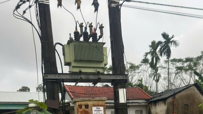
Professional agencies warn of a high risk of flash floods and landslides in mountainous areas, and heavy rains threatening the safety of reservoirs and causing flooding in downstream areas, riverside areas and urban areas.
People are advised to be cautious when traveling through spillway areas, as flooding can cause traffic congestion, impact the environment and threaten lives.
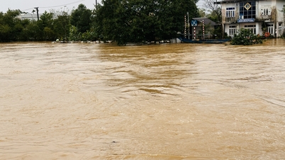
Also on the same morning, in many places in Khanh Hoa province, floodwaters on rivers and streams began to rise rapidly after heavy rains that lasted from November 16.

Floodwaters in Khe River (Khanh Vinh commune) rose to people's houses - Photo: NGOC THOA
In Nam Nha Trang ward, households in Thanh Dat and Thanh Phat residential groups were assisted by authorities to evacuate to a safe place as this is an area prone to landslides.
Khanh Vinh commune leaders said that the water level on Khe river is rising, many places in the area have been flooded since the evening of November 16, people have begun to evacuate to safety.
In addition, many traffic routes in the commune have been cut off due to deep flooding, and flood points have been cordoned off by authorities.

Floodwater from the river rose and overflowed onto the road in Khanh Vinh commune - Photo: NGOC THOA
In Cam Hiep commune, commune leaders said that some roads from the commune center leading to Valy and Suoi Coc villages were deeply flooded, making it difficult for people to travel. Commune authorities mobilized and brought 17 households to the village hall for temporary shelter.
In some other mountainous communes, authorities have set up checkpoints, placed warnings of danger, and prevented people from passing through the spillway areas to ensure safety.
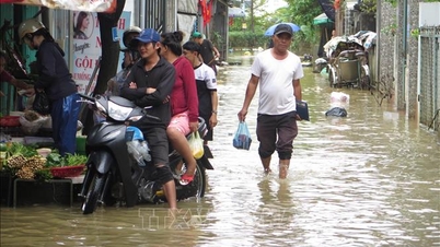
Currently this afternoon, many sections of National Highway 1 through Cam Ranh and Cam Lam areas of Khanh Hoa are flooded. Many sections are so deeply flooded that motorbikes cannot pass through, cars have difficulty moving, causing traffic jams that stretch for many kilometers.

Floodwaters flooded National Highway 1 through Cam Ranh ward this afternoon - Photo: VP

Flooding in Cam Ranh ward - Photo: VP
Source: https://tuoitre.vn/khanh-hoa-canh-bao-lu-khan-cap-dia-phuong-to-chuc-so-tan-dan-vung-xung-yeu-20251117101417842.htm


![[Photo] General Secretary To Lam and National Assembly Chairman Tran Thanh Man attend the 80th Anniversary of the Traditional Day of the Vietnamese Inspection Sector](https://vphoto.vietnam.vn/thumb/1200x675/vietnam/resource/IMAGE/2025/11/17/1763356362984_a2-bnd-7940-3561-jpg.webp)


Comment (0)