
During the period from the evening of October 23 to the morning of October 26, the average rainfall was from 60 to 150 mm. Some stations recorded very heavy rainfall such as: Hoa Xuan Nam (Hoa Xuan commune) 268.6 mm; Hoa Tam (Hoa Xuan commune) 207.6 mm; Cu San (Krong A commune) 184.2 mm...
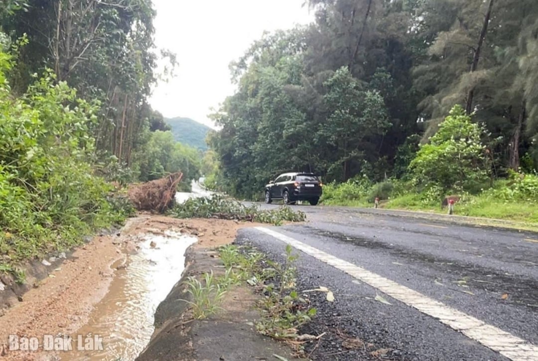 |
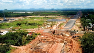
| Heavy rain caused landslides, flooding the road and blocking drainage ditches on National Highway 29. Photo: Ho Nhu |
Heavy rains flooded 20 houses in Son Tho and Thuong Phu neighborhoods (Binh Kien Ward). The water has now receded. 2.7 hectares of vegetables in Binh Kien Ward were flooded, with over 70% damage. More than 30 meters of the fence of Nguyen Viet Xuan Primary School (Binh Kien Ward) collapsed. Many irrigation works and canals in the fields were also eroded and damaged (currently, localities are reviewing and compiling specific data).
Heavy rain also caused National Highway 29 (at km2+150 to km3+400, km6, through Hoa Xuan commune) to have a landslide on the positive slope, with rocks and soil filling the drainage ditch and part of the road surface; National Highway 1A (at km1363+800 through Hoa Xuan commune) had a landslide on the slope, at km1365+630 water overflowed the road, bringing rocks and soil with it; some commune roads were partially flooded, causing temporary isolation in Krong A commune (Song Choi village and Ea Sanh village), Cu Pui commune (route from Ea Bar village to Cu Dram), and Yang Mao commune (traffic route of Yang Han village).
Immediately after the incident, the localities mobilized the disaster prevention and control force to clean up, put up ropes, and put up danger warning signs to ensure the safety of people and vehicles passing by. The Department of Agriculture and Environment also directed the on-duty team to closely monitor and promptly inform about warning bulletins and hydrometeorological forecasts.
According to the forecast of the Provincial Hydrometeorological Station, from now until October 27, moderate and heavy rains are still likely to occur, and it is forecasted that floods on the Ba River, Ky Lo River and Ban Thach River will reach alert levels 1-2. There is a high risk of flooding in the downstream of Ban Thach River (including the communes/wards of Dong Hoa, Hoa Xuan, Hoa Thinh); localized flooding in the fields along the Krong Bong River and the confluence of the Krong Bong River into the Krong Ana River.
The Department of Agriculture and Environment is continuing to closely monitor developments to promptly update and report to the Provincial People's Committee for consideration and direction.
Source: https://baodaklak.vn/kinh-te/202510/mua-lon-tai-dak-lak-gay-thiet-hai-ve-ha-tang-giao-thong-va-san-xuat-dd00ec8/


![[Photo] General Secretary To Lam received the delegation attending the international conference on Vietnam studies](https://vphoto.vietnam.vn/thumb/1200x675/vietnam/resource/IMAGE/2025/10/26/1761456527874_a1-bnd-5260-7947-jpg.webp)
![[Photo] Nhan Dan Newspaper displays and solicits comments on the Draft Documents of the 14th National Party Congress](https://vphoto.vietnam.vn/thumb/1200x675/vietnam/resource/IMAGE/2025/10/26/1761470328996_ndo_br_bao-long-171-8916-jpg.webp)
![[Photo] Enjoy the Liuyang Fireworks Festival in Hunan, China](https://vphoto.vietnam.vn/thumb/1200x675/vietnam/resource/IMAGE/2025/10/26/1761463428882_ndo_br_02-1-my-1-jpg.webp)


![[Photo] Prime Minister Pham Minh Chinh attends the opening of the 47th ASEAN Summit](https://vphoto.vietnam.vn/thumb/1200x675/vietnam/resource/IMAGE/2025/10/26/1761452925332_c2a-jpg.webp)


Comment (0)