
On October 26, the Central Hydrometeorological Station reported that in the past 24 hours, Da Nang City has had moderate to heavy rain, and in some places very heavy rain, and the situation will continue to be complicated and last for the coming days.
Accordingly, the total rainfall from 7am on October 25 to 7am on October 26 was generally 30-100mm, with some places as high as Tra My 145mm, Tam Tra 144mm, Tra Don 74mm. Heavy rain concentrated from last night to this morning.
 causes traffic congestion")
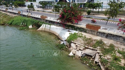
In the next 24 to 48 hours, the total rainfall in communes and wards in the plains and mountainous areas of the Northwest is forecast to be from 150-350mm, in some places over 450mm, in communes and wards in the mountainous areas of the South it is generally 200-400mm, in some places over 500mm. The soil moisture model shows that some areas in Da Nang City are nearly saturated (over 90%). Heavy rain has caused some landslides in the highland communes of Da Nang City.
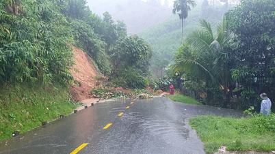
On National Highway 40B, passing through the 5-storey waterfall area in Nam Tra My commune, heavy rain caused landslides and local traffic jams. In addition, on the inter-commune road of Tra Tap, rocks and soil from the slope of Tuy Duong river flowed down onto the road, temporarily cutting off traffic.

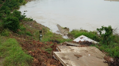
Heavy rain also flooded some low-lying roads such as the temporary bridge on National Highway 40B at Tien Hiep intersection (in Lanh Ngoc commune); the inter-commune road leading to Tra Lien commune was flooded at the temporary bridges.
Local authorities have issued notices advising people to limit going out unless absolutely necessary. At the same time, they are proactively checking around residential areas to prevent landslides.

According to forecasts, in the next 6 hours, there is a risk of flash floods on small rivers and streams in mountainous areas. At the same time, landslides on slopes and land subsidence in 59 communes and wards in Da Nang city.
It is forecasted that in the next 6 hours, Da Nang city will continue to have moderate to heavy rain, and in some places very heavy rain. Total rainfall is generally from 30-60mm, in some places over 80mm; in the mountainous areas southwest of the city, it is generally 40-60mm, in some places over 100mm. Also in the next 6 hours, there is a risk of flash floods on small rivers and streams in mountainous areas; landslides on steep slopes, and land subsidence in 56 communes and wards in Da Nang city.
Also this morning, Dak Mi Hydropower Joint Stock Company, Song Tranh Hydropower Joint Stock Company and A Vuong Hydropower Joint Stock Company announced the issuance of the Inter-reservoir Operation Procedures on the Vu Gia - Thu Bon River Basin. Accordingly, the expected flow through the spillway is from 500 m 3 /s - 2,500 m 3 /s, from 10 m 3 /s - 1,490 m 3 /s and from 25 m 3 /s - 600 m 3 /s (depending on the amount of water flowing into the reservoir).
Source: https://www.sggp.org.vn/da-nang-mua-lon-gay-sat-lo-ngap-cuc-bo-o-nhieu-tuyen-duong-mien-nui-post820007.html
![[Photo] General Secretary To Lam received the delegation attending the international conference on Vietnam studies](https://vphoto.vietnam.vn/thumb/1200x675/vietnam/resource/IMAGE/2025/10/26/1761456527874_a1-bnd-5260-7947-jpg.webp)
![[Photo] Prime Minister Pham Minh Chinh and United Nations Secretary-General Antonio Guterres attend the Press Conference of the Hanoi Convention Signing Ceremony](https://vphoto.vietnam.vn/thumb/1200x675/vietnam/resource/IMAGE/2025/10/25/1761391413866_conguoctt-jpg.webp)


![[Photo] Prime Minister Pham Minh Chinh attends the opening of the 47th ASEAN Summit](https://vphoto.vietnam.vn/thumb/1200x675/vietnam/resource/IMAGE/2025/10/26/1761452925332_c2a-jpg.webp)


![[Photo] National Assembly Chairman Tran Thanh Man receives United Nations Secretary-General Antonio Guterres](https://vphoto.vietnam.vn/thumb/1200x675/vietnam/resource/IMAGE/2025/10/25/1761390815792_ctqh-jpg.webp)


Comment (0)