
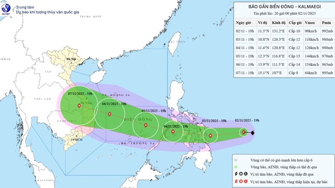
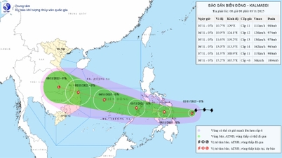
Updated position and path of storm Kalmaegi at 8:00 p.m. on November 2. Source: National Center for Hydro-Meteorological Forecasting
According to the National Center for Hydro-Meteorological Forecasting, at 7:00 p.m. on November 2, the center of storm Kalmaegi was located at about 11.3 degrees north latitude; 131.2 degrees east longitude, in the sea east of the central Philippines. The strongest wind near the center of the storm was level 10 (89 - 102 km/h), gusting to level 13. The storm moved westward at a fast speed of about 30 - 35 km/h.
In the next 24 hours, the storm is forecast to move mainly westward at a speed of about 20 km/h and is likely to strengthen. At 7:00 p.m. on November 3, the center of the storm was at about 10.8 degrees north latitude; 126.3 degrees east longitude, in the sea east of the central Philippines. The strongest wind near the center of the storm is level 12, gusting to level 15.
Forecast in the next 48 hours , the storm will move west-northwest, speed 20 - 25 km/h. At 7:00 p.m. on November 4, the center of the storm will be at about 11.4 degrees north latitude; 120.8 degrees east longitude, west of the central Philippines. The strongest wind near the center of the storm is level 12, gusting to level 15.
The danger zone in the next 48 hours is north of latitude 10 - 19.5 degrees north and east of longitude 117.5 degrees east. Disaster risk level 3 for the sea area east of the central East Sea.
It is forecasted that in the next 72 hours, the storm will move west-northwest at a speed of 15-20 km/h and may intensify. At 7:00 p.m. on November 5, the center of the storm will be at about 12.3 degrees north latitude; 116.8 degrees east longitude, in the central East Sea. Wind speed is level 13, gusting to level 17.
The danger zone in the next 72 hours is north of latitude 10 - 15 degrees north and east of longitude 114.5 degrees east. Disaster risk level 3 for the central East Sea area (including Truong Sa special zone).
It is forecasted that in the next 72 to 120 hours, the storm will move mainly in the west-northwest direction, about 20 - 25 km per hour and is likely to continue to strengthen.
Storm impact at sea, from the afternoon of November 4, the sea area east of the central East Sea has winds gradually increasing to level 6 - 7, then increasing to level 8 - 9; the area near the storm center has strong winds of level 10 - 12, gusts of level 14 - 15, waves 5 - 7 m high, rough seas.
During November 5-6, the central East Sea area (including Truong Sa special zone), the sea area off the coast of Da Nang - Khanh Hoa is likely to be affected by strong winds of level 12-14, gusts of over level 17, waves of 8-10 m high, and rough seas. All ships and structures operating in the above-mentioned dangerous area are likely to be strongly affected by storms, whirlwinds, strong winds and big waves.
Source: https://laodong.vn/moi-truong/sap-don-bao-so-13-co-the-manh-len-giat-den-cap-17-truoc-khi-do-bo-1602576.ldo
![[Photo] Prime Minister Pham Minh Chinh receives the Chairman of the Japan-Vietnam Friendship Association in the Kansai region](https://vphoto.vietnam.vn/thumb/1200x675/vietnam/resource/IMAGE/2025/11/03/1762176259003_ndo_br_dsc-9224-jpg.webp)
![[Photo] General Secretary To Lam receives Singaporean Ambassador Jaya Ratnam](https://vphoto.vietnam.vn/thumb/1200x675/vietnam/resource/IMAGE/2025/11/03/1762171461424_a1-bnd-5309-9100-jpg.webp)
![[Photo] Lam Dong: Close-up of illegal lake with broken wall](https://vphoto.vietnam.vn/thumb/1200x675/vietnam/resource/IMAGE/2025/11/03/1762166057849_a5018a8dcbd5478b1ec4-jpg.webp)
![[Photo] Fall Fair 2025 and impressive records](https://vphoto.vietnam.vn/thumb/1200x675/vietnam/resource/IMAGE/2025/11/03/1762180761230_ndo_br_tk-hcmt-15-jpg.webp)


Comment (0)