
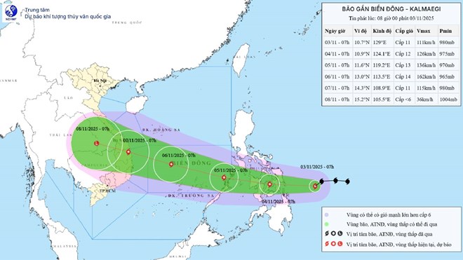
Updated position and path of storm Kalmaegi at 2:00 p.m. on November 3. Source: National Center for Hydro-Meteorological Forecasting
According to the National Center for Hydro-Meteorological Forecasting, at 1 p.m. on November 3, the center of storm Kalmaegi was located at about 10.4 degrees north latitude; 127.9 degrees east longitude, in the sea east of the central Philippines. The strongest wind near the center of the storm was level 12 (118-133 km/h), gusting to level 15. The storm moved west-southwest at a fast speed of about 25 km/h.
In the next 24 hours, the storm is forecast to move mainly westward at a speed of about 25km/h. At 1:00 p.m. on November 4, the center of the storm was at about 10.9 degrees north latitude; 122.2 degrees east longitude, in the central Philippines. Wind force is level 12, gusting to level 15.
Forecast in the next 48 hours , the storm will move west-northwest, speed 20-25km/h and likely to strengthen, entering the East Sea. At 13:00 on November 5, the center of the storm will be at about 12 degrees north latitude; 117.6 degrees east longitude, in the sea area east of the central East Sea. Strong winds level 13, gusts level 16.
The dangerous area in the East Sea in the next 24 hours is from latitude 10-15 degrees north and east of longitude 115.5 degrees east. Disaster risk level 3, central area of the East Sea (including Truong Sa special zone).
It is forecasted that in the next 72 hours, the storm will move west-northwest at a speed of about 25km/h and is likely to strengthen. At 13:00 on November 6, the center of the storm will be at about 13.4 degrees north latitude; 112 degrees east longitude, in the middle of the East Sea, about 340km east-southeast of the coast of Gia Lai province. Wind speed is level 14, gusting to level 17.
Danger zone from latitude 10-16.5 degrees north and east of longitude 110 degrees east. Disaster risk level 4, the area between the East Sea (including Truong Sa special zone) and the sea area from Da Nang to Khanh Hoa.
From the next 72 to 108 hours , the storm will move mainly in the west-northwest direction, 20-25km per hour, gradually weakening.
Regarding the impact of the storm , from around the afternoon of November 4, the sea area east of the central East Sea will have winds gradually increasing to level 6-7, then increasing to level 8-9; the area near the storm center will have strong winds of level 10-12, gusting to level 14-15, waves 5-7m high, and rough seas.
During November 5-6, the area between the East Sea (including Truong Sa special zone) and the sea off the coast of Da Nang - Khanh Hoa is likely to be affected by strong winds of level 12-14, gusts of over level 17, waves of 8-10m high, and rough seas. All ships and structures operating in the above-mentioned dangerous area are strongly affected by storms, whirlwinds, strong winds and big waves.
Laodong.vn
Source: https://laodong.vn/moi-truong/sap-don-bao-so-13-rat-manh-du-bao-khu-vuc-chiu-anh-huong-dau-tien-tu-chieu-411-1602915.ldo
![[Photo] The road connecting Dong Nai with Ho Chi Minh City is still unfinished after 5 years of construction.](https://vphoto.vietnam.vn/thumb/1200x675/vietnam/resource/IMAGE/2025/11/04/1762241675985_ndo_br_dji-20251104104418-0635-d-resize-1295-jpg.webp)
![[Photo] Ho Chi Minh City Youth Take Action for a Cleaner Environment](https://vphoto.vietnam.vn/thumb/1200x675/vietnam/resource/IMAGE/2025/11/04/1762233574890_550816358-1108586934787014-6430522970717297480-n-1-jpg.webp)
![[Photo] Ca Mau "struggling" to cope with the highest tide of the year, forecast to exceed alert level 3](https://vphoto.vietnam.vn/thumb/1200x675/vietnam/resource/IMAGE/2025/11/04/1762235371445_ndo_br_trieu-cuong-2-6486-jpg.webp)


![[Photo] Panorama of the Patriotic Emulation Congress of Nhan Dan Newspaper for the period 2025-2030](https://vphoto.vietnam.vn/thumb/1200x675/vietnam/resource/IMAGE/2025/11/04/1762252775462_ndo_br_dhthiduayeuncbaond-6125-jpg.webp)


Comment (0)