

Around the afternoon of November 6, the storm will move into the central sea area and from the night of November 6, the storm will likely directly affect the area from Da Nang to Khanh Hoa.
Storm 13 is very strong when entering the East Sea
Director Mai Van Khiem said: Forecasting agencies of Japan, China and Vietnam, through discussions, all agreed that when entering the East Sea, storm 13 will be very strong with an intensity that can reach level 13-14, gusting to level 17, then the storm will move towards the mainland of Vietnam, focusing on the provinces and cities from Da Nang to Dak Lak .
It is forecasted that around the afternoon of November 6, the storm will cause strong winds in the coastal area from Da Nang to Khanh Hoa with strong winds of level 10-12, gusting to level 15. Deep inland, there is a possibility of strong storm winds of level 7-9, gusting to level 13-14.
"This is a very strong storm, with a wide storm circulation and strong winds that directly affect coastal provinces and cities from South Quang Tri to Dak Lak (the path and impact are similar to storm No. 12 - (Damrey) in 2017 and storm No. 9 (Molave) in 2020). Along with that, the intensity and direction of the storm also determine the area of rain and heavy rainfall. The National Center for Hydro-Meteorological Forecasting will continue to monitor because the scenarios of intensity and direction of movement, the center of rain and rainfall due to the impact of the storm are likely to fluctuate in the coming days," Mr. Mai Van Khiem emphasized.
Storm No. 13 and its circulation cause strong winds and heavy rain in many areas.
Director Mai Van Khiem said that the cold air is currently weakening and there are no signs of it strengthening again. At the same time, the activity of the east wind zone is not strong, so the rain is mainly caused by the distant circulation of storm No. 13.
Specifically, from the evening of November 6, on the mainland along the coast from South Quang Tri to Da Nang city, the East of Quang Ngai and Dak Lak provinces, the wind gradually increased to level 6-7, then increased to level 8-9, the area near the storm's center passed through level 10-12 (in the center is the East of Quang Ngai - Dak Lak provinces), gusting to level 14-15.
From the evening and night of November 6, the western part of Quang Ngai and Gia Lai provinces will gradually increase the wind to level 6-7, the area near the storm's eye will increase to level 8, gusting to level 10.
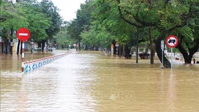
From November 6 to 7, the area from Da Nang city to Dak Lak will have very heavy rain with common rainfall of 200-400mm/period, locally over 600mm/period; the area from South Quang Tri to Hue city, Khanh Hoa and Lam Dong will have heavy rain, locally very heavy rain with common rainfall of 150-300mm/period, locally over 450mm/period. From November 8, heavy rain in the above areas is likely to decrease.
From November 7-8, the area from North Quang Tri to Thanh Hoa will have moderate rain, heavy rain, and locally very heavy rain with common rainfall of 50-150mm/period, locally over 200mm/period. Warning of risk of heavy rain over 200mm/3 hours.
Providing more information about the flood situation, Mr. Mai Van Khiem said that, according to available data, up to this point, the flood level this time will be lower than the flood peak from October 22 to 29 in the Central region, fluctuating at alert level 2 - alert level 3.
Affected by the storm, many sea areas have very high waves and violently rough seas.
Referring to the storm's impact on sea areas, the Director of the National Center for Hydro-Meteorological Forecasting said that in the central East Sea (including the sea area north of Truong Sa special zone), the wind will gradually increase to level 7-8, then increase to level 9-11; the area near the storm's eye will have strong winds of level 12-14, gusts of level 17, waves 5-7m high, the area near the storm's eye will have waves of 8-10m high, and the sea will be very rough.
From early morning on November 6, the sea area from Da Nang city to Khanh Hoa (including Ly Son special zone) gradually increased wind to level 6-7, then increased to level 8-11; the area near the storm center had strong wind at level 12-14, gusting to level 17, waves 4-6m high, the area near the storm center had waves 6-8m high, the sea was very rough.
Mr. Mai Van Khiem warned that from the evening of November 5, coastal areas from Hue city to Dak Lak should be on guard against sea level rise of 0.3 - 0.6m accompanied by large waves causing flooding in low-lying areas, waves overflowing dikes, coastal roads, coastal landslides, slowing down flood drainage in the area.
"All ships, boats, and aquaculture areas in the above-mentioned dangerous areas are strongly affected by storms, whirlwinds, strong winds, large waves, and rising sea levels. Due to the influence of the wide storm circulation, it is necessary to guard against the risk of thunderstorms, whirlwinds, and strong gusts of wind both before and during the storm's landing," Mr. Khiem noted.
Source: https://baotintuc.vn/van-de-quan-tam/tu-dem-611-bao-so-13-co-kha-nang-anh-huong-truc-tiep-den-da-nang-khanh-hoa-20251104194947673.htm
![[Photo] Ho Chi Minh City Youth Take Action for a Cleaner Environment](https://vphoto.vietnam.vn/thumb/1200x675/vietnam/resource/IMAGE/2025/11/04/1762233574890_550816358-1108586934787014-6430522970717297480-n-1-jpg.webp)
![[Photo] Ca Mau "struggling" to cope with the highest tide of the year, forecast to exceed alert level 3](https://vphoto.vietnam.vn/thumb/1200x675/vietnam/resource/IMAGE/2025/11/04/1762235371445_ndo_br_trieu-cuong-2-6486-jpg.webp)

![[Photo] The road connecting Dong Nai with Ho Chi Minh City is still unfinished after 5 years of construction.](https://vphoto.vietnam.vn/thumb/1200x675/vietnam/resource/IMAGE/2025/11/04/1762241675985_ndo_br_dji-20251104104418-0635-d-resize-1295-jpg.webp)

![[Photo] Panorama of the Patriotic Emulation Congress of Nhan Dan Newspaper for the period 2025-2030](https://vphoto.vietnam.vn/thumb/1200x675/vietnam/resource/IMAGE/2025/11/04/1762252775462_ndo_br_dhthiduayeuncbaond-6125-jpg.webp)


Comment (0)