

Long-term planning
Bac Kan City is facing a great opportunity to dramatically “transform” in terms of space, infrastructure and urban functions. The new planning project was established on the basis of inheriting, updating and overall adjusting the old project (approved in 2012), which is now outdated after more than a decade of rapid urbanization.
According to the Submission of the Department of Construction, the preparation and approval of this planning project is an inevitable requirement to ensure consistency with the Bac Kan Provincial Planning approved by the Prime Minister in Decision No. 1288/QD-TTg in 2023. At the same time, this project is also an important legal basis for urban management and development in the context of Bac Kan about to merge with Thai Nguyen in the spirit of Resolution No. 60-NQ/TW of the 13th Party Central Committee.
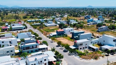
The scale and stature of a central urban area in the Northeast region
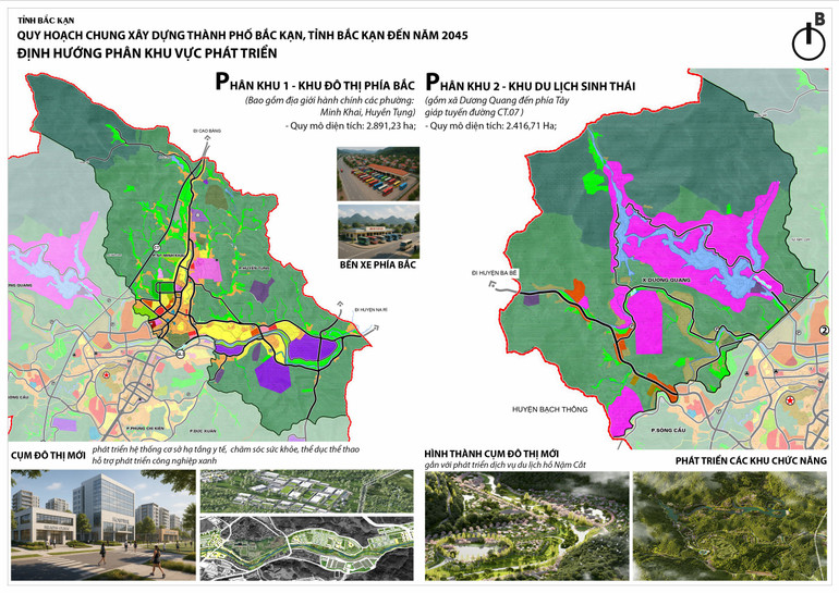
The project defines the planning scope as the entire administrative boundary of Bac Kan city with an area of about 13,209.5 hectares. It is forecasted that by 2045, the city will have a population of about 130,000 people, of which the urban population accounts for 92%.
The city space is organized according to the strategic structure: “One green corridor – Two spatial axes – Three development belts”. In which, the Cau River axis is the main development center, while the Truong Chinh axis will be the dynamic connecting axis towards the Cho Moi – Bac Kan highway. The urban belts link industrial, commercial and tourist spaces to create a tightly connected functional network.
The project is divided into 5 major development areas: Northern urban area, developing healthcare, sports and green industry in Nguyen Thi Minh Khai and Huyen Tung wards. Eco-tourism area, in Duong Quang commune, connecting Nam Cat lake, planning resorts, spiritual tourism, forest ecology. Urban center area, maintaining the role of administrative, political, commercial center, renovating and upgrading infrastructure, increasing green space. Gateway logistics area, in Nong Thuong commune, associated with developing trade and foreign traffic. Ethnic village ecological area, in Xuat Hoa ward, promoting cultural identity, community tourism.
The project focuses on developing green technical infrastructure, applying modern technology in urban management, wastewater treatment, renewable energy and smart drainage. The transportation system is expanded synchronously with belt routes, expressway connecting axes, gateway bus stations, Cau River overpasses, etc. All are aimed at building Bac Kan into a smart, green and sustainable city.
Economic development associated with local identity
The plan also identifies important economic development drivers such as: Industry - handicrafts in the Eastern belts. Eco-tourism, resorts, culture, history, associated with Ba Be National Park and ethnic cultural heritage. High-tech agriculture, organic agriculture and agricultural tourism services.

Bac Kan Department of Construction has completed the appraisal process, collecting opinions from the people, organizations and the Ministry of Construction. The project is assessed as being in accordance with the law, higher-level planning orientations and the practical needs of the province.
“The early approval of the project by the Provincial People's Committee will create an important legal basis for Bac Kan city to implement public investment projects, develop infrastructure, attract businesses and manage urban development more effectively.”
Mr. Ha Minh Cuong, Deputy Director of Department of Construction.
In the future, Bac Kan city is expected to be an attractive eco-tourism destination, a core connecting the Northeast region. With a systematic, synchronous and long-term planning, Bac Kan will have enough internal strength to develop into a model urban area in the mountainous region, blending modernity and national cultural identity./.
Source: https://baobackan.vn/tam-nhin-2045-bac-kan-huong-toi-do-thi-vung-cao-kieu-mau-post71104.html


![[Photo] General Secretary To Lam receives Chief of the Central Office of the Lao People's Revolutionary Party](https://vphoto.vietnam.vn/thumb/1200x675/vietnam/resource/IMAGE/2025/5/30/140435f4b39d4599a3d17975dfb444c5)


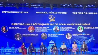
![[Photo] National Conference "100 years of Vietnamese Revolutionary Press accompanying the glorious cause of the Party and the nation"](https://vphoto.vietnam.vn/thumb/1200x675/vietnam/resource/IMAGE/2025/5/30/1cf6cd5c8a934ebfa347028dcb08358c)


Comment (0)