
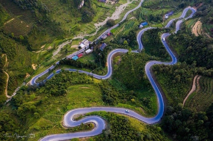
Ma Pi Leng is one of the majestic “four great mountain passes” in the northern mountainous region of our country, along with O Quy Ho, Pha Din and Khau Pha. Although Ma Pi Leng Pass is not the longest, it is known as the “king” of mountain passes thanks to its extremely rugged terrain with winding, twisting curves. On one side of the pass are mountains, on the other side are deep ravines.
Ma Pi Leng Pass Possessing 9 winding bends on the steep mountainside, below is a deep abyss, becoming a place that backpackers crave to conquer.
What does the name Ma Pi Leng mean?
Ma Pi Leng Pass was named after Ma Pi Leng village in Pai Lung when the road was opened in the 1960s. Later, the road management authorities changed "Ma" to "Ma" to make it easier to hear in the common language.
Ma Pi Leng in the H'Mong language means "horse's nose". Some say that this name refers to the most dangerous part of this mountain peak, where the slope is so steep that a horse passing over it would die, or the mountain peak is as steep as a horse's nose.
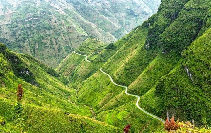
Ma Pi Leng Peak is about 1,200 - 1,600m above sea level. The mountain range is formed by a series of sediments including limestone, schist, siliceous limestone containing fossils about 426 million years ago, including many slides and cracks caused by mountain-building activities. The landscape of this area is rugged and rocky, in which the deep abyss of Nho Que River seems to split Ma Pi Leng Peak on one side and Xin Cai on the other.
Many years ago, Ma Pi Leng peak in particular and Dong Van Karst Plateau Global Geopark in general were considered a "Geological Monument". Going on Ma Pi Leng pass and looking down into the abyss, we see Nho Que river as small as a thread.
In 2009, Ma Pi Leng area was recognized as a National Scenic Monument. Accordingly, Ma Pi Leng scenic spots include: Ma Pi Leng Pass is considered a special heritage area in terms of geology and landscape, the peak of the pass is considered one of the most beautiful panoramic observation points in Vietnam, Nho Que river canyon is one of the unique tectonic valleys in Vietnam.
The best time to experience Ma Pi Leng
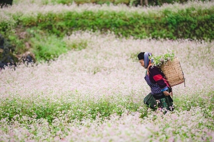
Ma Pi Leng is located in the old Ha Giang province. This place is likened to the muse of the great forest, possessing majestic and poetic beauty. Ma Pi Leng Pass can welcome tourists to explore at any time of the year.
If you come to this land between January and March, you will see peach and plum blossoms blooming brilliantly. From May to July is the time when the golden sunshine and clear blue sky make the scenery here most beautiful.
In September and October, this land is covered with the golden color of ripe rice fields. In November, you can admire the season buckwheat flowers gorgeous
Places to experience around Ma Pi Leng Pass
The green Nho Que River meanders at the foot of Ma Pi Leng Pass, symbolizing the poetic beauty of this place. The experience of taking a boat on this river not only brings a sense of peace but also gives you the opportunity to admire Tu San Canyon - the deepest canyon in Southeast Asia.
The journey through the winding roads of Ma Pi Leng Pass is a challenging but worthwhile experience. With towering mountains on one side and a deep abyss on the other, this majestic scene brings both thrill and excitement to anyone who loves to explore .
In addition, if you stand on the top of Ma Pi Leng pass and look down, you will see the whole view of Dong Van stone plateau - a place recognized by UNESCO as a global geopark.
The precarious cliff at Ma Pi Leng is a favorite stop for virtual life enthusiasts. From here, you can admire the majestic scenery of Ma Pi Leng Pass and Nho Que River.
Source: https://baolangson.vn/ten-goi-ma-pi-leng-co-nghia-gi-5063844.html
![[Photo] Opening of the 14th Conference of the 13th Party Central Committee](https://vphoto.vietnam.vn/thumb/1200x675/vietnam/resource/IMAGE/2025/11/05/1762310995216_a5-bnd-5742-5255-jpg.webp)


![[Photo] Panorama of the Patriotic Emulation Congress of Nhan Dan Newspaper for the period 2025-2030](https://vphoto.vietnam.vn/thumb/1200x675/vietnam/resource/IMAGE/2025/11/04/1762252775462_ndo_br_dhthiduayeuncbaond-6125-jpg.webp)


Comment (0)