
According to international meteorological agencies, on the evening of September 18, Vietnam time, the tropical depression numbered 24W strengthened into tropical storm Ragasa. The name Ragasa was nominated by the Philippines, meaning "quick", "speed", "lightning speed". This is the 18th storm to operate in the Northwest Pacific region since the beginning of 2025 and the 4th storm in September.
Currently, the Joint Typhoon Warning Center (JTWC - USA) assesses that Ragasa storm is likely to increase in strength very quickly during the weekend (from September 20 to 22). This center believes that the storm may reach super typhoon level when entering the East Sea.
 and storm Mitag (number 8). Source: Z.E")
The Japan Meteorological Agency (JMA) has also recognized Ragasa as an international tropical storm and issued a five-day forecast track. The US National Oceanic and Atmospheric Administration (NOAA) has forecasted that Ragasa will move east of the Philippines before heading into the South China Sea.
 predicted that the center of storm Ragasa would head towards the North of Luzon Island (Philippines).")
According to the JTWC forecast, Ragasa could intensify to the equivalent of a Category 4 or even Category 5 storm as it moves through the energetic waters east of Luzon Island (Philippines). Meanwhile, data from Cyclocane website shows that the storm is moving northwest.
 forecast model of typhoons Ragasa and Mitag")
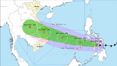
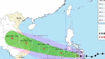
On social networks, some meteorological experts believe that Ragasa will become storm number 9 in the East Sea around September 23. According to the long-term trajectory forecast model provided by the European Center for Medium-Range Weather Forecasts (ECMWF), this storm is likely to pass through the Leizhou Peninsula (China), then directly affect the North Central region and the Northern Delta of Vietnam, especially the Thanh Hoa - Ninh Binh region.
 is about to make landfall in Guangdong (China). Photo by the National Center for Hydro-Meteorological Forecasting")
Previously, on September 18, the representative of the National Center for Hydro-Meteorological Forecasting, Mr. Nguyen Van Huong, Head of the Weather Forecast Department, gave preliminary information about this storm. According to Mr. Huong, this is a strong storm, making landfall directly on our mainland, causing strong winds and heavy rain in the North, from Thanh Hoa to Hue.
People in the coastal provinces of the North and Central regions need to closely monitor information about this storm from Vietnam's meteorological agencies and international meteorological agencies such as JTWC, JMA, NOAA to have timely response plans.
Source: https://www.sggp.org.vn/them-bao-ragasa-than-toc-dang-huong-vao-bien-dong-post813675.html
![[Photo] Ca Mau "struggling" to cope with the highest tide of the year, forecast to exceed alert level 3](https://vphoto.vietnam.vn/thumb/1200x675/vietnam/resource/IMAGE/2025/11/04/1762235371445_ndo_br_trieu-cuong-2-6486-jpg.webp)

![[Photo] Panorama of the Patriotic Emulation Congress of Nhan Dan Newspaper for the period 2025-2030](https://vphoto.vietnam.vn/thumb/1200x675/vietnam/resource/IMAGE/2025/11/04/1762252775462_ndo_br_dhthiduayeuncbaond-6125-jpg.webp)
![[Photo] The road connecting Dong Nai with Ho Chi Minh City is still unfinished after 5 years of construction.](https://vphoto.vietnam.vn/thumb/1200x675/vietnam/resource/IMAGE/2025/11/04/1762241675985_ndo_br_dji-20251104104418-0635-d-resize-1295-jpg.webp)

![[Photo] Ho Chi Minh City Youth Take Action for a Cleaner Environment](https://vphoto.vietnam.vn/thumb/1200x675/vietnam/resource/IMAGE/2025/11/04/1762233574890_550816358-1108586934787014-6430522970717297480-n-1-jpg.webp)


Comment (0)