
Regarding heavy rain , the National Center for Hydro-Meteorological Forecasting said that on the day and night of November 4, in the area from Thanh Hoa to the East of Quang Ngai , the Central Highlands and the South, there will be scattered showers and thunderstorms with rainfall of 15-30mm, locally heavy rain over 70mm. During thunderstorms, there is a possibility of tornadoes, lightning, hail and strong gusts of wind. Warning of the risk of heavy rain >60mm/3h. During thunderstorms, there is a possibility of tornadoes, lightning, hail and strong gusts of wind. Local heavy rain can cause flash floods on small rivers and streams, landslides on steep slopes and flooding in low-lying areas.
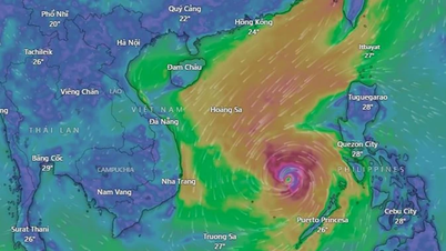
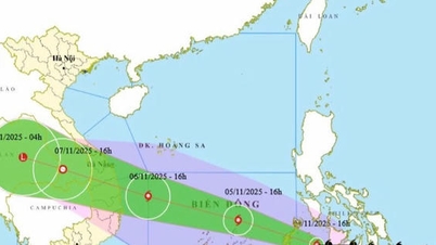
Regarding Typhoon Kalmaegi , at 7:00 a.m. on November 4, the eye of the storm was located at approximately 10.7 degrees North latitude; 123.5 degrees East longitude, in the central region of the Philippines. The strongest wind near the eye of the storm was level 13 (134-149 km/h), gusting to level 16. The storm moved in a West Northwest direction at a speed of approximately 20 km/h.
National Center for Hydro-Meteorological Forecasting forecasts in the next 24-72 hours:

From the next 72 to 96 hours, the storm will move mainly in the West Northwest direction, traveling 20-25km per hour, and its intensity will continue to weaken.
Due to the impact of the storm, from around the afternoon of November 4, the sea area east of the central East Sea will have winds gradually increasing to level 6-7, then increasing to level 8-10; the area near the storm center will have strong winds of level 11-13, gusting to level 15-16, waves 5-7m high. The sea will be very rough.
On November 5-6, the Central East Sea area (including the sea area north of Truong Sa special zone), the sea area off the coast of Da Nang - Khanh Hoa is likely to be affected by strong winds of level 12-14, gusting to level 17, waves of 8-10m high. The sea will be very rough.
All ships and structures operating in the above-mentioned dangerous area are strongly affected by storms, whirlwinds, strong winds and big waves.
Source: https://baophapluat.vn/mua-rao-tai-trung-bo-va-nam-bo-bao-giat-cap-16-sap-vao-bien-dong.html
![[Photo] Ca Mau "struggling" to cope with the highest tide of the year, forecast to exceed alert level 3](https://vphoto.vietnam.vn/thumb/1200x675/vietnam/resource/IMAGE/2025/11/04/1762235371445_ndo_br_trieu-cuong-2-6486-jpg.webp)

![[Photo] Panorama of the Patriotic Emulation Congress of Nhan Dan Newspaper for the period 2025-2030](https://vphoto.vietnam.vn/thumb/1200x675/vietnam/resource/IMAGE/2025/11/04/1762252775462_ndo_br_dhthiduayeuncbaond-6125-jpg.webp)
![[Photo] Ho Chi Minh City Youth Take Action for a Cleaner Environment](https://vphoto.vietnam.vn/thumb/1200x675/vietnam/resource/IMAGE/2025/11/04/1762233574890_550816358-1108586934787014-6430522970717297480-n-1-jpg.webp)
![[Photo] The road connecting Dong Nai with Ho Chi Minh City is still unfinished after 5 years of construction.](https://vphoto.vietnam.vn/thumb/1200x675/vietnam/resource/IMAGE/2025/11/04/1762241675985_ndo_br_dji-20251104104418-0635-d-resize-1295-jpg.webp)


Comment (0)