

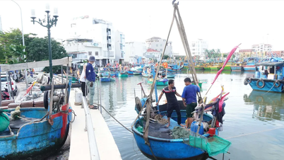
On the evening of November 3, the Office of the Department of Hydrometeorology ( Ministry of Agriculture and Environment ) informed the press that it had sent an official dispatch to the Office of the National Civil Defense Steering Committee, the People's Committees of the provinces and cities: Nghe An, Ha Tinh, Quang Tri, Hue, Da Nang, Quang Ngai, Gia Lai, Dak Lak, Khanh Hoa, Lam Dong and related ministries about the situation of rain - floods and storm Kalmaegi.
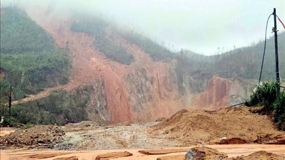
Currently, floods on rivers in the Central region are at high levels, widespread flooding is occurring in many localities.

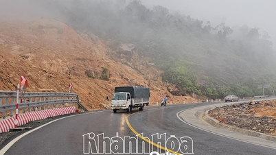
Regarding the heavy rain situation, due to the influence of continuously strengthened cold air, combined with many factors (tropical convergence zone, low pressure area in the South China Sea, high-altitude easterly wind disturbance), from the afternoon of November 3 to the end of November 4, the area from Ha Tinh province to Hue city will continue to have heavy to very heavy rain, with common rainfall of 150-250mm, locally over 400mm (from November 5 to November 6, rain in the above area is likely to decrease).
Regarding storm Kalmaegi, it is forecasted that around the morning of November 5, storm Kalmaegi will enter the East Sea and become storm number 13 in 2025.
Although the observation data up to November 3 still has uncertainty about the trajectory and intensity, some of the latest forecast results show that the storm is moving fast and has a very strong intensity. The National Center for Hydro-Meteorological Forecasting will issue an emergency storm warning as soon as the storm enters the East Sea (morning of November 5).

According to the Director of the Department of Hydrometeorology, the storm may reach a level of 13-14 in the Truong Sa special zone and in the sea area of Da Nang - Khanh Hoa. From the night of November 6, the storm may directly affect the area from Da Nang to Khanh Hoa. The strongest wind in coastal waters (including Ly Son special zone) may reach level 12-13, gusting over level 15. Inland coastal areas may reach level 10-12, gusting to level 14-15. This is a strong storm, thunderstorms and tornadoes may occur before the storm.
The Department of Meteorology and Hydrology warns that floods on rivers in the Central region are currently at high levels, widespread flooding is occurring in many localities. The People's Committees of localities are requested to direct the units managing and operating reservoirs to closely monitor the meteorological and hydrological situation, implement the monitoring and forecasting regime, provide information, data and reporting regime according to the regulations of the Department of Meteorology and Hydrology to serve the forecasting and warning work.
Source: https://www.sggp.org.vn/bao-kalmaegi-co-the-do-bo-khu-vuc-da-nang-khanh-hoa-post821544.html

![[Photo] Ho Chi Minh City Youth Take Action for a Cleaner Environment](https://vphoto.vietnam.vn/thumb/1200x675/vietnam/resource/IMAGE/2025/11/04/1762233574890_550816358-1108586934787014-6430522970717297480-n-1-jpg.webp)
![[Photo] Ca Mau "struggling" to cope with the highest tide of the year, forecast to exceed alert level 3](https://vphoto.vietnam.vn/thumb/1200x675/vietnam/resource/IMAGE/2025/11/04/1762235371445_ndo_br_trieu-cuong-2-6486-jpg.webp)
![[Photo] The road connecting Dong Nai with Ho Chi Minh City is still unfinished after 5 years of construction.](https://vphoto.vietnam.vn/thumb/1200x675/vietnam/resource/IMAGE/2025/11/04/1762241675985_ndo_br_dji-20251104104418-0635-d-resize-1295-jpg.webp)

![[Photo] Panorama of the Patriotic Emulation Congress of Nhan Dan Newspaper for the period 2025-2030](https://vphoto.vietnam.vn/thumb/1200x675/vietnam/resource/IMAGE/2025/11/04/1762252775462_ndo_br_dhthiduayeuncbaond-6125-jpg.webp)


Comment (0)