
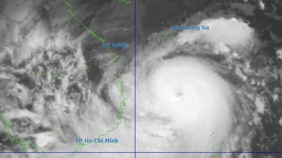
The strongest wind near the storm center is level 8 - 9 (62-88km/h), gusting to level 11. The storm moves northwest at a speed of about 15km/h.
It is forecasted that by 4 p.m. the same day, the storm's center will be at about 22.6 degrees North latitude; 115 degrees East longitude, on the southern coastal area of Guangdong province (China), maintaining a level 8-9 intensity, gusting to level 11. By the morning of September 20, the storm will make landfall in the southern part of Guangdong province, gradually weakening into a tropical depression, then continue to move deeper inland and gradually dissipate.
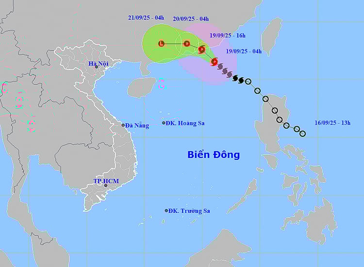
Due to the influence of the storm circulation, on the day and night of September 19, the eastern sea area of the North East Sea, the central and southern East Sea (including the Truong Sa sea area), the Gulf of Tonkin, the sea area from South Quang Tri to Ca Mau, Ca Mau to Kien Giang and the Gulf of Thailand will have scattered showers and thunderstorms. Particularly, the northern sea area of the East Sea will have strong winds of level 6 - 7, gusts of level 9; the area near the storm's center will have strong winds of level 8 - 9, gusts of level 11, waves 3 - 5m high, very rough seas. Ships operating in the danger zone are at risk of being affected by strong winds, big waves, and whirlwinds.
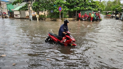
On land, the Northern region has scattered showers and thunderstorms, while in Southern Phu Tho, the plains and coastal areas there are scattered showers and thunderstorms. The provinces from Thanh Hoa to Quang Tri, the Central Highlands and the Southern region have scattered showers and thunderstorms, with some areas experiencing heavy to very heavy rain. Some stations have recorded heavy rainfall such as: Quynh Luu (Nghe An); Ho Canh Chim (Thanh Hoa); Da Mi Ri - Da Huoai Town ( Lam Dong ).
It is forecasted that from early morning to afternoon of September 19, the coastal areas of the North will have scattered showers and thunderstorms with rainfall ranging from 10 - 30mm, with some places experiencing over 60mm. In the afternoon and evening, the provinces from Quang Ngai to Lam Dong will have scattered showers and thunderstorms, with some places experiencing over 70mm. There is a high risk of heavy rain with an intensity of over 60 - 80mm/3 hours.
Thunderstorms may produce tornadoes, lightning, hail, and strong gusts of wind. Localized heavy rains may cause flash floods in small rivers and streams, landslides in mountainous areas, and localized flooding in low-lying areas.
Localities, especially coastal areas, need to closely monitor storm developments and prepare response plans to ensure safety for people and production activities.
Weather forecast for regions across the country:
Hanoi is cloudy, with occasional showers and thunderstorms during the day and no rain at night. Light winds. During thunderstorms, there is a possibility of tornadoes, lightning, and strong gusts of wind. Lowest temperature 23 - 26 degrees Celsius. Highest temperature 31 - 33 degrees Celsius.
The Northwestern provinces are cloudy with scattered showers and thunderstorms, especially in the Southern Phu Tho region where there are scattered showers and thunderstorms. Light winds. During thunderstorms, there is a possibility of tornadoes, lightning and strong gusts of wind. The lowest temperature is 23 - 26 degrees Celsius, in some places below 22 degrees Celsius. The highest temperature is 31 - 34 degrees Celsius.
The Northeastern region is cloudy with scattered showers and thunderstorms, with scattered showers and thunderstorms in the plains and coastal areas, with some heavy rain. Light wind. During thunderstorms, there is a possibility of tornadoes, lightning and strong gusts of wind. The lowest temperature is 23 - 26 degrees Celsius, in mountainous areas it is below 22 degrees Celsius. The highest temperature is 30 - 33 degrees Celsius, in some places it is above 33 degrees Celsius.
Provinces from Thanh Hoa to Hue are cloudy, with scattered showers and thunderstorms during the day, with some places experiencing heavy to very heavy rain; showers and thunderstorms at night in some places. Light wind. During thunderstorms, there is a possibility of tornadoes, lightning, hail and strong gusts of wind. Lowest temperature 23 - 26 degrees Celsius. Highest temperature 28 - 31 degrees Celsius, some places above 31 degrees Celsius.
The South Central Coast region is cloudy with scattered showers and thunderstorms; in the evening there will be scattered showers and thunderstorms, with some places having heavy rain. Southwest wind level 2 - 3. During thunderstorms there is a possibility of tornadoes, lightning, hail and strong gusts of wind. The lowest temperature is 24 - 27 degrees Celsius. The highest temperature is 30 - 33 degrees Celsius, some places above 33 degrees Celsius.
The Central Highlands is cloudy with scattered showers and thunderstorms; in the afternoon there will be scattered showers and thunderstorms, with some heavy rain in some places. Southwest wind level 2-3. During thunderstorms there is a possibility of tornadoes, lightning, hail and strong gusts of wind. Lowest temperature 20-23 degrees Celsius. Highest temperature 27-30 degrees Celsius.
The South is cloudy with scattered showers and thunderstorms, with some places experiencing heavy rain. Southwesterly winds level 2-3. During thunderstorms, there is a possibility of tornadoes, lightning, hail and strong gusts of wind. Lowest temperature 23-26 degrees Celsius. Highest temperature 29-32 degrees Celsius, some places above 32 degrees Celsius.
Ho Chi Minh City is cloudy with scattered showers and thunderstorms, some places have heavy rain. Southwest wind level 2 - 3. During thunderstorms, there is a possibility of tornadoes, lightning, hail and strong gusts of wind. Lowest temperature 24 - 26 degrees Celsius. Highest temperature 29 - 32 degrees Celsius, some places above 32 degrees Celsius.
Source: https://baotintuc.vn/xa-hoi/thoi-tiet-ngay-199-bao-so-8-di-chuyen-vao-dat-lien-quang-dong-trung-quoc-20250919054022101.htm


![[Photo] Da Nang: Hundreds of people join hands to clean up a vital tourist route after storm No. 13](https://vphoto.vietnam.vn/thumb/1200x675/vietnam/resource/IMAGE/2025/11/07/1762491638903_image-3-1353-jpg.webp)


Comment (0)