
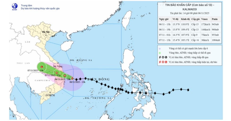
The storm is moving very fast in the West Northwest direction at a speed of 25-30km/h.
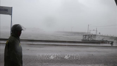
Due to the storm's influence, many places have recorded very strong gusts of wind. As of 1 p.m., Ly Son station (Quang Ngai) had strong winds of level 7, gusts of level 9; Phu Cat (Gia Lai) strong winds of level 7, gusts of level 10; and Hoi An ( Da Nang ) strong winds of level 8, gusts of level 9.
Storm forecast to make landfall this evening, November 6
According to forecasts, the storm will directly affect the mainland in the next few hours:
By 7:00 p.m. on November 6: The storm center is right on the coastal area from Quang Ngai to Dak Lak . The strongest wind when making landfall is level 13, gusting to level 15.
By 1am on November 7: The storm moves deep into the mainland area from Quang Ngai - Dak Lak and gradually weakens. The strongest wind is still level 8-9, gusting to level 11.
By 1:00 p.m. on November 7: The storm weakened into a low pressure area over the eastern part of Thailand.
Strong wind warning on land
The meteorological agency warned that the strongest wind time on land will begin from this evening to tonight (November 6).
On land, the area from South Da Nang City to Dak Lak will have winds gradually increasing to level 6-7, then increasing to level 8-9.
The focus is the area near the storm's eye, including the East of Quang Ngai-Gia Lai provinces and the North of Dak Lak. Winds will be strong at level 10-13, gusting to level 15-16.
Areas from South Quang Tri to North Da Nang City and North Khanh Hoa province have strong winds of level 6-7, gusting to level 8-9.
Warning of extremely heavy rain, over 600mm in some places
Due to the influence of the storm, from the afternoon of November 6 to November 7, a very heavy rain will occur:
Area from Da Nang City to Dak Lak: Very heavy rain with common rainfall of 200-400mm/period. Special warning: Locally over 600mm/period.
Area from South Quang Tri to Hue City, Khanh Hoa and Lam Dong: Heavy rain with common rainfall of 150-300mm/period, locally very heavy rain over 450mm/period.
From November 8, heavy rain in the above areas will tend to decrease.
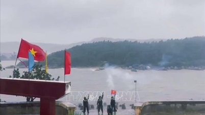
Wave and water surge warning
At sea: The sea area west of the Central East Sea (including the sea area from South Quang Tri to Khanh Hoa) has strong winds of level 13-15, gusting over level 17. Waves near the storm center are from 9.0 to 11.0m high, with rough seas.
Storm surge: Coastal areas from South Quang Tri to Dak Lak have storm surges of 0.5-1.0m high. Warning of flooding in low-lying areas, coastal landslides and waves overtopping dikes. All boats and aquaculture areas in the danger zone are strongly affected by the storm.
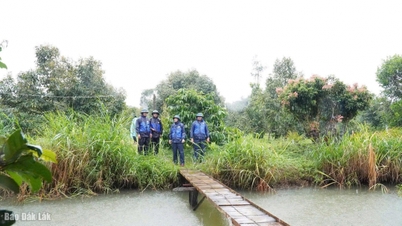
The meteorological agency also warned of the risk of thunderstorms, tornadoes and strong gusts of wind both before and during the storm's landfall.
Source: https://baonghean.vn/tin-bao-khan-cap-bao-kalmaegi-bao-so-13-manh-cap-15-giat-tren-cap-17-tam-bao-huong-vao-quang-ngai-dak-lak-10310524.html


![[Photo] Prime Minister Pham Minh Chinh receives the delegation of the Semiconductor Manufacturing International (SEMI)](https://vphoto.vietnam.vn/thumb/1200x675/vietnam/resource/IMAGE/2025/11/06/1762434628831_dsc-0219-jpg.webp)


Comment (0)