 |
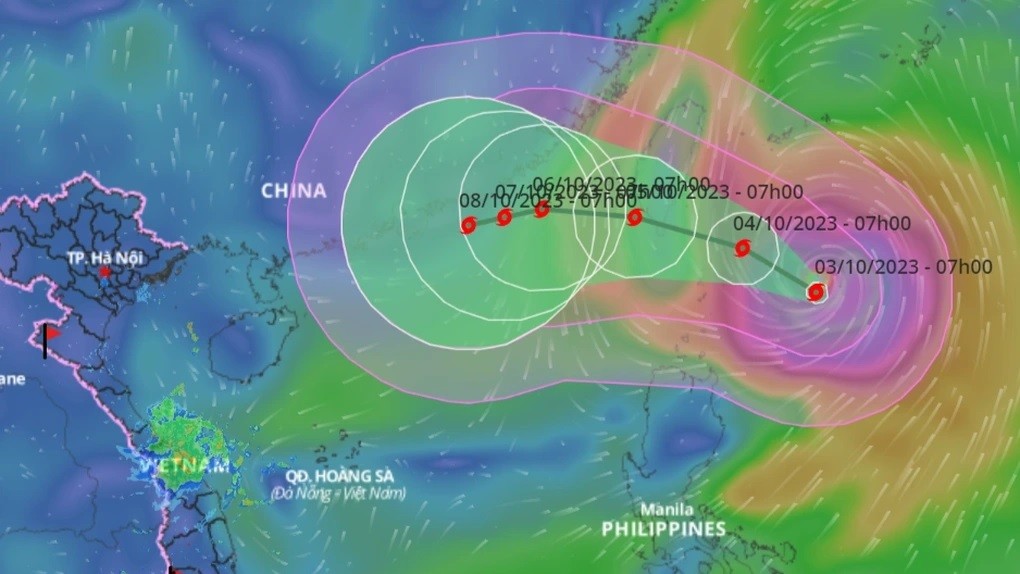
| Forecast of the path of storm Koinu entering the East Sea. (Source: VNDMS) |
Developments and impacts of storm Koinu
Forecast of storm Koinu's developments in the next 24 hours
Forecast time | Affected sea areas | Strong winds | Wave height | ||
Wind level (Bophorus level) | Direction | Height (meters) | Direction | ||
Night of October 3rd | The northeastern sea of the North East Sea | Level 6-7, gust level 8-9. Rough sea. | North to Northwest | 2-4m | North Northeast |
In addition, on the day and night of October 3, in the eastern sea of the central East Sea, the sea from Quang Tri to Quang Ngai, the sea from Ca Mau to Kien Giang and the Gulf of Thailand, there will be showers and thunderstorms.
During thunderstorms there is a possibility of tornadoes and strong gusts of wind level 6-7.
Warning
On October 4, the northeastern sea area of the North East Sea will have strong winds of level 6-7, gusting to level 8-9; rough seas; waves 2-4m high.
From the night of October 4, the storm will strengthen to level 8-10, near the eye of the storm level 11-13, gusting to level 16; rough seas; waves 5-7m high.
Warning level of natural disaster risk due to strong winds at sea: Level 2.
Impact forecast
All vessels and other activities in the above sea areas are at high risk of being affected by strong winds and large waves.
Provinces and cities from Quang Ninh to Khanh Hoa proactively respond to storm Koinu
It is forecasted that due to the influence of storm Koinu, from the night of October 3, the northeastern sea area of the North East Sea will have winds gradually increasing to level 6-7; from the night of October 4, the winds will increase to level 8-10, the area near the storm center will have winds of level 11-13, gusting to level 16, and the sea will be very rough.
On the morning of October 5, storm Koinu entered the northeastern sea area of the North East Sea.
On October 3, the Standing Office of the National Steering Committee for Natural Disaster Prevention and Control issued Document No. 368/VPTT to the Command Committee for Natural Disaster Prevention and Control and Search and Rescue of coastal provinces and cities from Quang Ninh to Khanh Hoa, and the Command Committee for Natural Disaster Prevention and Control and Search and Rescue of the Ministry of Transport on proactively responding to storm Koinu in the northeastern sea of the Philippines.
To proactively respond to the developments of storm Koinu, the Standing Office of the National Steering Committee for Natural Disaster Prevention and Control requested the above provinces and cities to closely monitor the developments of storm Koinu; review and notify vehicles and ships operating at sea to proactively avoid and not enter dangerous areas.
The danger zone in the next 24-48 hours is north of latitude 19.0; east of longitude 118.0 and is adjusted in forecast bulletins.
Localities review forces and means, be ready to deploy rescue work when situations arise, and at the same time organize serious on-duty shifts, regularly report to the Standing Office of the National Steering Committee for Natural Disaster Prevention and Control and the Office of the National Committee for Incident, Disaster Response and Search and Rescue.
Source


![[Photo] Cutting hills to make way for people to travel on route 14E that suffered landslides](https://vphoto.vietnam.vn/thumb/1200x675/vietnam/resource/IMAGE/2025/11/08/1762599969318_ndo_br_thiet-ke-chua-co-ten-2025-11-08t154639923-png.webp)











![[Photo] "Ship graveyard" on Xuan Dai Bay](https://vphoto.vietnam.vn/thumb/1200x675/vietnam/resource/IMAGE/2025/11/08/1762577162805_ndo_br_tb5-jpg.webp)


![[Video] Hue Monuments reopen to welcome visitors](https://vphoto.vietnam.vn/thumb/402x226/vietnam/resource/IMAGE/2025/11/05/1762301089171_dung01-05-43-09still013-jpg.webp)









Comment (0)