
Typhoon Kalmaegi is forecast to be a strong storm in the East Sea (possibly over level 12). Around November 7, the storm is likely to affect the Da Nang - Khanh Hoa area.
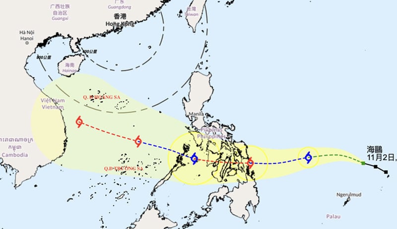 |
| Forecast of the location and direction of storm Kalmaegi on the morning of November 2 - Photo: HKO |
The Japan Meteorological Agency (JMA) said that at 7:00 a.m. this morning, the center of typhoon Kalmaegi was about 1,000 km east of the central Philippines, with the strongest wind near the center of the storm at level 9 (23 m/s), gusting to level 11.
Typhoon Kalmaegi reaches maximum intensity of level 12 in the East Sea
JMA forecasts that in the coming days, the storm will move mainly westward, towards the central Philippines, with the storm's intensity likely to increase to level 12 (35 m/s) before sweeping across the Philippines.
From morning to noon on November 5, Typhoon Kalmaegi is likely to enter the East Sea. After entering the East Sea, the storm will move west-northwest and may intensify to level 13 (40 m/s).
Hong Kong Radio (HKO) also shares the same opinion about the storm's path. However, HKO believes that after entering the East Sea, typhoon Kalmaegi will reach its maximum intensity of level 12 (130km/h).
The National Center for Hydro-Meteorological Forecasting said forecast data as of November 1 shows that around November 5 (Wednesday), storm Kalmaegi could enter the East Sea and become the 13th storm this year.
Typhoon Kalmaegi is forecast to be a strong storm in the East Sea, possibly at level 12 and strongest in the Truong Sa special zone. Around November 7, the storm is likely to move (make landfall) in our country, the focus area that needs to be noted that is likely to be directly impacted is from Da Nang to Khanh Hoa .
The storm may cause strong winds and heavy rain in the provinces of the Central Central, South Central and Central Highlands regions from the night of November 6 to 9.
The meteorological agency noted that the storm is currently affected by many large-scale factors in the coming days as well as the impact of terrain when it makes landfall in the Philippines. Therefore, scenarios on the intensity, direction of movement as well as the areas directly affected by storm No. 13 still need to be monitored and updated with new observation and forecast data.
From Ha Tinh to Da Nang and the east of Quang Ngai province there is heavy to very heavy rain.
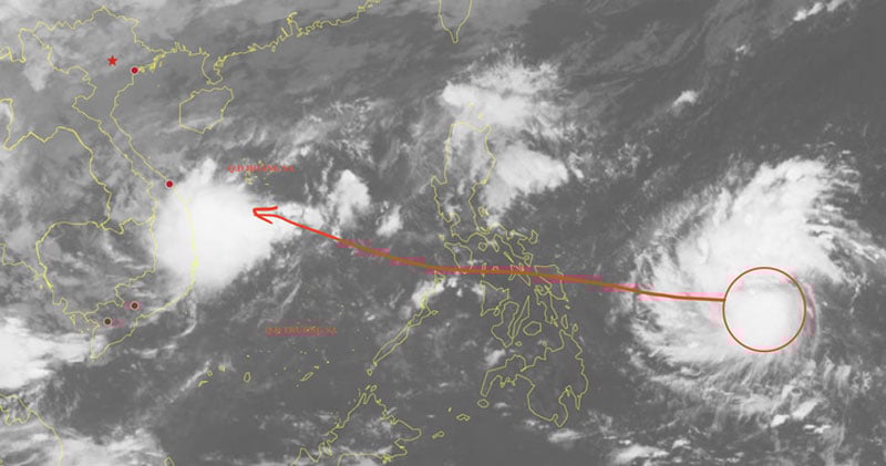 |
| Satellite image of typhoon Kalmaegi on the morning of November 2 - Photo: NCHMF |
In the immediate future, due to the influence of the low pressure trough connecting with the low pressure area in the offshore area of Quang Ngai - Khanh Hoa provinces, combined with cold air and easterly winds from above, from this morning to early morning of November 4, the area from Ha Tinh to Da Nang and the east of Quang Ngai province will have heavy to very heavy rain.
Total rainfall in Hue, Da Nang and eastern Quang Ngai province is generally 300-500mm, locally over 750mm.
In Ha Tinh and Quang Tri areas, rainfall is generally 200-350mm, locally over 500mm. In the south of Nghe An province and the west of Quang Ngai, there is moderate to heavy rain with rainfall generally 70-150mm, locally over 250mm.
Today (November 2), in the east of Gia Lai province, there will be moderate to heavy rain with common rainfall of 40-80mm, locally very heavy rain over 150mm. In the west of Gia Lai province, from Dak Lak to Lam Dong and the South, there will be scattered showers and thunderstorms with rainfall of 10-30mm, locally heavy rain over 70mm.
During the day and night of November 4, the area from Ha Tinh to Da Nang will continue to have moderate to heavy rain with common rainfall of 30-70mm, locally very heavy rain of over 150mm. Heavy rain is likely to cause flooding in low-lying areas, riverside areas, urban areas and landslides, flash floods in mountainous areas of the above provinces.
Many coastal areas have thunderstorms and strong winds.Also due to the influence of the northeast monsoon, the low trough connecting with the low pressure area, today in the northern East Sea area (including Hoang Sa special zone), the northeast wind is level 6, from noon and afternoon sometimes level 7, gusting to level 8-9, waves 3-5m high. In the Gulf of Tonkin, the northeast wind is level 5, sometimes level 6, gradually increasing to level 6 from noon and afternoon, gusting to level 7-8, with waves 1.5-3m high. The sea area from southern Quang Tri to Quang Ngai has the northeast wind is level 5, sometimes level 6, gusting to level 7-8, with waves 2-3m high. The southern area of the Gulf of Tonkin, the sea area from Quang Tri to Ca Mau, from Ca Mau to An Giang, the Gulf of Thailand, the northern and central areas of the East Sea (including the Hoang Sa special zone) will have scattered showers and thunderstorms. During the thunderstorms, there is a possibility of tornadoes, strong gusts of wind of level 6-7 and waves over 2m high. Warning day and night 3/11, the northern East Sea area (including Hoang Sa special zone) has strong northeast wind level 6-7, gusts level 8-9, rough sea, waves 3-5m high. The Gulf of Tonkin has strong northeast wind level 6, sometimes level 7, gusts level 8, rough sea, waves 2-3.5m high. The sea area from South Quang Tri to Quang Ngai has strong northeast wind level 5, sometimes level 6, gusting to level 7-8, rough sea, waves 2-3m high. All vessels operating in the above areas are at high risk of being affected by strong winds and large waves. |
According to tuoitre.vn
Source: https://baovinhlong.com.vn/tin-moi/202511/bao-kalmaegi-la-con-bao-manh-tren-bien-dong-co-the-anh-huong-da-nang-khanh-hoa-75611ed/
![[Photo] Ca Mau "struggling" to cope with the highest tide of the year, forecast to exceed alert level 3](https://vphoto.vietnam.vn/thumb/1200x675/vietnam/resource/IMAGE/2025/11/04/1762235371445_ndo_br_trieu-cuong-2-6486-jpg.webp)
![[Photo] Panorama of the Patriotic Emulation Congress of Nhan Dan Newspaper for the period 2025-2030](https://vphoto.vietnam.vn/thumb/1200x675/vietnam/resource/IMAGE/2025/11/04/1762252775462_ndo_br_dhthiduayeuncbaond-6125-jpg.webp)

![[Photo] Ho Chi Minh City Youth Take Action for a Cleaner Environment](https://vphoto.vietnam.vn/thumb/1200x675/vietnam/resource/IMAGE/2025/11/04/1762233574890_550816358-1108586934787014-6430522970717297480-n-1-jpg.webp)
![[Photo] The road connecting Dong Nai with Ho Chi Minh City is still unfinished after 5 years of construction.](https://vphoto.vietnam.vn/thumb/1200x675/vietnam/resource/IMAGE/2025/11/04/1762241675985_ndo_br_dji-20251104104418-0635-d-resize-1295-jpg.webp)


Comment (0)